Introduction
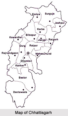
Bastar District is located in Chhattisgarh in the central parts of India. Bastar District, before splitting into three districts, was one of the largest districts in India, with an area of 39114 sq km. The district headquarters are in located at Jagdalpur. The district covers an area of around 8755.79 sq km. Bastar District is located in the southern part of Chhattisgarh and is situated at a height of 2000 ft plateau from sea level. Bastar District is bounded by Kanker District in the north, by Maharashtra in the west, by Dantewada District in the south and by Odisha in the east.

History of Bastar District
Early history of Bastar District is obscure and it appears that the central part of this region formed by the kingdom of the Nagavanshi family who had their capital at Barsur. Their kingdom was known as `Chakrakot.` This kingdom subsequently formed part of the Warangal Kingdom of the Kakatiya dynasty.

Further, according to the history of Bastar District, the Bastar Raj family claims its descent from the Pandu king, Birbhadra of Delhi. Birbhadra subsequently moved to Mathura where he received a trident from goddess Bhuwaneshwari. Then he moved on to Jajpur (Odisha). Later on they settled at Warangal with Manikya Devi (or Danteshwari as she is called in Bastar inscriptions), their family goddess, who granted them a sword when they moved to Bastar. Interestingly, all these weapons are still worshipped by the people.
The Kakatiyas were great patrons of learning and the great commentator Mallinath flourished under their patronage. Brother of great Kakatiya King Pratap Rudra, Annam Deo, left Warangal and established his kingdom at Bastar, after 1424 AD. He was succeeded by Hamir Deo and then by Pratap Raj Deo. It appears from the history of Bastar District that Bastar branch of the Kakatiya family vanished and after that Donger and Bastar came under Rajpal Deo.
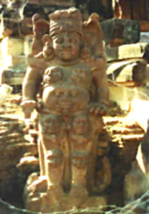
Eventually, Mahipal Deo succeeded the throne of Bastar, and after his death, Bhopal Deo succeeded. Bhairam Deo was the next successor. Bhairam Deo died in 1891 and the state was managed by the government until January 1908. In 1910 a tribal revolt occurred against the British government who ruled over the state. Raja Rudrapratap Deo died in 1921 and his daughter Praphul Kumari Devi ascended the throne in 1922. In the year 1948, Bastar District has been merged in Indian Union. Bastar District is quite rich in archaeological remains. Old buildings and inscriptions are found at Barsur, Dantewada, Bhairamgarh, Narainpal, Kuruspal and Dhanora.
At Barsur there is a temple dedicated to Lord Shiva with 12 stone pallets carved on the outside with various sculptures. However they are in a damaged state. The archaeological remains of this district of Chhattisgarh also include a ruined Ganesh temple. Another temple around 50 ft high known as `Mama Bhanja Ka Mandir` has carvings representing bells hung from chains and it is in a fair state of preservation. Several other temples are scattered across the place and there are collections of beautifully carved images of Lord Vishnu and other deities. At Bairamgarh, doorway of an old fort, several tanks and some old temple ruins can be seen.
According to the history, Bastar District and Dantewada District were part of the princely state of Bastar. After the independence of the country in 1947, the princely states of Bastar and Kanker were handed over to the Government of India. Then they were merged to form Bastar District of Madhya Pradesh. In the year 1999, the district was divided into the existing districts of Bastar, Dantewada, and Kanker, which cumulatively form the Bastar Division with the divisional head quarter at Jagdalpur. In the year 2000, Bastar District became one of the 16 districts of the newly formed state Chhattisgarh, which was earlier in Madhya Pradesh.
Geography of Bastar District
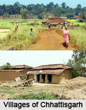
Geography of Bastar District depicts mostly the iron rich soils and hot summer climate in summer times. Bastar district is divided into two tehsils: Jagdalpur and Bastar. The district has one municipality, which is known as Jagdalpur. Jagdalpur is the administrative headquarters of Bastar District and the forest region of Bastar Division. The tribal population is mostly concentrated here. Bastar is a beautiful city having a population of about 150,000.

Agriculture in Bastar District
The rice is grown predominantly during kharif season as rain fed crop having 2.38.9 million hectare areas. But the productivity of this crop is low 08.53 qt/ha in Bastar region of Chhattisgarh. The irrigated area and fertilizer use in the Bastar district are very less, which is insufficient to supply adequate nutrient to the crop.
Livelihood in Bastar District
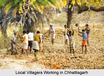
The pattern of livelihood is fully dependant on the geography. The landforms, soil texture and the climatic features are fully interlinked. The agricultural practices are traditional. Use of wooden ploughs is overwhelming while the number of iron ploughs is negligible. The same is true of bullock carts. The number of tractors is negligible while the bullock carts are all pervasive. The usage of traditional agricultural implements has lowered the production of agriculture. The kharif crops grown here are paddy, Urad, Arhar, Jowar and maize. The rabi crops include til, alsi, moong, mustard and gram. The collection and sale of forest produce and other forest-related work supplements meager agricultural incomes.
Forests in Baster District
Bastar District is abundantly and richly endowed with forest resources. The forests in this district can be divided in to four belts, namely, Northern Mixed forests, Central Moist Region comprising of Sal belts, Teak belt zone and the dry region comprising mixed forests.
The forests play an important role in the lives of the people, providing food security and livelihood through the collection of minor forest produce, and employment (as casual labour) in the Forest Department of Chhattisgarh. The forests provide for people"s consumption needs - fuel and firewood, medicines, food and drink, implements and housing materials. The forty percent of livelihoods are forest based, 30 percent are agriculture based and 15 percent of livelihoods are dependent on animal husbandry. Another 15 percent of the income of people comes from wage labour.
Rivers in Baster District
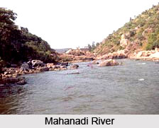
Geography of Bastar District is characterized by its vast natural forest area and prominent rivers. The total forest area of the district is roughly 7112 sq km which is more than 75 per cent of the total area of the district. The largest and the most important river in Bastar district is Indravati River which has numerous tributaries, the largest being the Pamer Chinta. The Indravati River rises from Rampur Thuamul in Odisha and flowing through the Bastar division for around 240 miles finally merges into Godavari River in Dantewada District. Owing to its rocky bed the river is not navigable. Interestingly, neither the river nor its tributaries dry up in the hot summer season.
Economic Dependency on Agriculture
Most of the tribal population in Chhattisgarh is dependant on agricultural industry. The people with a land are dependent almost entirely on cultivation, either on their own holdings or on the holdings of others. They supplement their income and consumption with animal husbandry, and sundry labour at times. Some of them have also diversified into small services or small manufacturing activities.
Culture of Bastar District
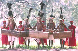
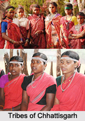
Culture of Bastar District is mainly tribal in nature as it is a basically a tribal district. The tribal culture of Bastar District is unique as well as unusual. In Bastar District, the different tribal castes have their own different indigenous customs, traditional and religious practices. Moreover, the dialect used by the tribal communities also differs.

Tribal district Bastar in Chhattisgarh is full of festivals which include harvest festivals like Navakhana, Mati Puja (worship of the land), Goncha (the chariot festival), etc. Many of the Hindu festivals are observed by the people in a different way. The most important festival in Bastar District is Dussehra. Dussehra in Bastar is devoted entirely to Goddess, Danteshwari Devi. Bastar Dussehra is believed to have been started by Maharaj Purushaottam Deo, the fourth Kakatiya ruler of Bastar. The festival involves participation of all major tribes of Bastar District. Bastar Dussehra has several components, each of which has a history of its own.
The important festivals of Gond Tribe observed in the district are Navakhana and Chaitrai. Navakhana is observed in the month of September. On this day, Gonds offer new grain and liquor to their ancestors. In Kondagaon, Budha Deo is worshipped on this day. In Jagdalpur, this festival is observed by taking sweets and giving new clothes to the members of the family.
Country dances are the chief amusements of all the tribes of Bastar District and cock-fighting is their favourite pass time. The tribal society of Bastar is famous for their exotic handicrafts with a variety of designs and shapes. These handicrafts include wood-carvings, metal items, terracotta items, bamboo items, etc. In Bastar, being a district full of forest containing finest quality of teak and other types of woods, several attractive wooden carving crafts and various types of furniture are made by the skilled tribal people. Wood crafts are another most famous, beautiful and unique art Bastar District. These wooden crafts are made out of the finest teak wood and white wood. These wooden crafts include idols, wall panels, furniture, etc. These handicrafts are generally exported to different places of the country and also in foreign countries.
Further, handicrafts of terracotta items of Bastar District are also very popular. These terracotta items include elephants, tigers, deer, horses, table lamps, etc. These handicrafts are of different sizes and shapes. Bastar District also specializes in bamboo crafts which include products like wall hangings, table lamps, table mats, etc. Wrought iron crafts are an indigenous Bastar tribal craft. Lastly, cotton fabrics are one of the famous and attractive handicrafts made by the tribal people of Bastar District. These are made of Kosa thread which is made from a kind of worm found in the forest, hand-woven and hand printed by the tribes. The hand printing is generally done with the natural vegetable dye. These fabrics include cotton saris - well-known as Bastar Kosa Sadi, dress materials and drapes.
Demography of Bastar District
The district has an average population of 1,302,253 as per the 2001 census. Of the total population more than 70 per cent are tribal people like Gond Tribe, Abhuj Maria, Darda Maria, Bison Horn Maria, Munia Doria, Dhruva, Bhatra, Halba Tribe, etc. Bastar District is divided into four tehsils, namely Jagdalpur, Kondagaon, Keshkal, and Narainpur. There are two municipalities, Jagdalpur and Kondagaon.
Tourism in Bastar District
Tourism in Bastar District means a pleasurable experience as this place is enriched with natural beauty and pleasant atmosphere. It is also known as the `Land of Tribal and Natural Resources.` Bastar District is surrounded with dense forests, hilly mountains, streams, waterfalls, natural caves, parks, etc.

The natural beauty of Bastar District attracts the tourists from different parts of the world. Moreover, the art and culture of this district are other main tourism attractions. The deep wide and thick forests, between bushes and bamboos, high mountains, flowing stream, caves, high waterfalls, sky-touching valleys, spread of greenery and in between huts made by bamboo sticks, etc. are some of the attractions for the travellers. Here, one can experience peace and tranquility.
There are so many places which are worth visiting in Bastar District. Further, there are several unexplored destinations too. The important tourist places in Bastar District are Chitrakot and Tiratgarh waterfalls, Kotamsar and Kailash caves, Kanger Valley National Park, etc. Indravati National Park, known for tigers and wild buffaloes is situated at a distance of 200 kms, west of Jagdalpur, is another place of worth seeing. The other key attractions of Bastar District include Danteshwari Temple, Bastar Palace, Anthropological Museum and a couple of beautiful lakes. This district of Chhattisgarh offers pilgrimage as well as nature tourism options to the visitors.

Nature Tourism in Bastar District
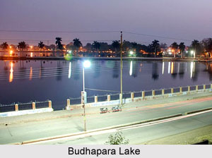
Lakes: The two prominent lakes of Bastar District are Ganga Munda and Dalpat Sagar located within the boundary of Jagdalpur town. These lakes are of great attraction for the tourists.
Chitrakot Waterfall: Chitrakot, the gorgeous waterfall is on river Indravati River, situated at a distance of 38 kms in the west of Jagdalpur. Height of this waterfall is approximately 100 ft. The Chitrakot waterfall is considered as the smaller form of the world famous Niagara Falls. This is the prime attraction for all tourists. It is worth seeing in rainy season, between July and October.
Tiratgarh Waterfall: This waterfall is situated at a distance of 35 kms from Jagdalpur in south west direction. The waterfall is actually situated in Kanger Valley National Park and the height is approximately 300 ft. The best season for visiting it is in between October to February.
Kutumsar Caves and Kailash Gufa: These are a biggest tourist attraction, and are close to Tiratgarh waterfall. Both Kutumsar Caves and Kailash Gufa are located in Kanger Valley National Park and situated at distances of 38 kms and 40 kms from Jagdalpur respectively.
Kanger Valley National Park: This Park is considered as a paradise for the nature lovers. The park is situated in a transition zone where southern limit of sal forests and northern limit of teak forests overlap. The Park derives its name from the Kanger River which flows throughout its length. There are many scenic spots along this perennial stream. Other bigger tourist attractions are the Kotamsar Caves, Kailash Caves, and limestone Caves etc.

In Bastar District., there are a chain of waterfalls and many other tourist places. The Mandawa waterfalls are located 12 kms away from Tokapal of Jagdalpur Tehsil. Another waterfall in Bastar district is Chitradhara, which is just 19 kms away from Jagdalpur.
Besides these there is the Danteshwari Temple. It is an ancient temple built by the kings of Bastar and it was dedicated to Goddess Danteshwari. This temple is located beside Bastar palace. It is worth seeing during Dussehra festival season. At this temple, the main traditional functions of the festivals are being carried out.
Travellers can also explore the Bastar Palace. It is other historical remains that are seen in Jagdalpur. It was the head quarters of Bastar Kingdom. It was built by the rulers of Bastar when the capital of Bastar kingdom had been shifted from Barsur to Jagdalpur. It reflects the rich historical past of the district.
How to Reach Bastar District
Jagdalpur the district head quarters of Bastar District is well connected by roads to other cities of Chhattisgarh. It is connected with the state capital, Raipur in the north by the National Highway (NH - 49) and the distance is approximately 300 kms. However, there is limited railway facility at Jagdalpur.