Home > Travel > States of India > Bastar Division
Bastar Division
Bastar Division is a division of the state of Chhattisgarh in India.

Share this Article:

The Bastar Division is an administrative division of Chhattisgarh state in the central part of the Indian subcontinent. It incorporates the districts of Bastar, Dantewada, and Kanker. Bastar Division came into being in 1999, when the bigger Bastar District was divided into the current districts of Bastar, Dantewada, and Kanker.

In 2000 the division was included under the state of Chhattisgarh. The Bastar District has its district headquarters in Jagdalpur. The district covers an area of 8755.79 square km. As boundaries it has the Rajnandgaon District on the northwest, the Kanker District on the north, the Dhamtari District on the northeast, the Navarangpur and the Koraput districts of the state of Orissa on the east, the Dantewada District on the south and southeast, and the Gadchiroli District of the state of Maharashtra on the east. Bastar Division
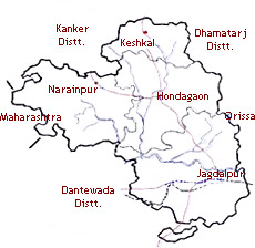
The district headquarters of the Dantewada District are in Dantewada. The district covers an area of 10,238.99 square km and has a total population of 719,065 (as per the 2001 census). The district has four tehsils, namely Bijapur, Bhopalpatnam, Dantewada, and Konta. It is surrounded by the Bastar District on the north and northeast, the Malkangiri District of the state of Orissa and the Indravati River on the east and the Khammam District of the state of Andhra Pradesh on the south and southwest. The Kanker District is positioned in the southern section of the state of Chhattisgarh between the longitudes 20.6- 20.24 and latitudes 80.48- 81.48. The district covers a total area of 5285.01 square kilometers. The district has many places of tourist attraction. Some of these are the Malanjhkudum Water fall, the Charre- Marre Water fall, the Gadiya Mountain and the Shivani Maa temple.


Share this Article:

Related Articles

More Articles in States of India


East Indian States
East Indian States comprises of Bihar, Jharkhand, West Bengal, Odisha and also the Union Territory of Andaman and Nicobar Islands. It defines the cultural heritage, rich historical background and the linguistic unity.
Erode District
Erode District is one of the districts in the state of Tamil Nadu. The district of Erode is having a land-locked area with no sea coast.
Purnia District in Bihar
Purnia District is located in Bihar and extends from River Ganga to Nepal. The district has a rich Hindu history and glorious past.
South Delhi District
South Delhi District is the third largest district of Delhi as far as its area is concerned. South Delhi District is known for its economic, historical, cultural and social significance.
North Indian States
North Indian States formed the cultural and religious unity in spite of having many foreign invasion and the political disturbances from the early era till the British gained supremacy in Indian sub continent.
Kendujhar District
Kendujhar District, spread over an area of 8,240 sq kms, is as varied as the whole of Orissa with waterfalls roaring gorges, mountains and minerals. The manifold expressions of nature in Kendujhar District are considered as unique.
Hooghly district
Hooghly District along the bank of the river Hooghly is one of the principal trading ports of West Bengal.
Districts of South Tamil Nadu
Districts of South Tamil Nadu consist of many tourism destinations like archaeological sites and the history of Pandyas and Cholas. Considering their proximity to the sea, many districts also boast of serene beaches and coastal beauty.
Flora of Arunachal Pradesh
Flora of Arunachal Pradesh includes infinite species and is a subject of great interests for the botanists.
Districts of South Gujarat
Districts of South Gujarat are the epicenter of Jain pilgrimages and the early Hindu kingdoms.
North West States of India
North West States of India consist of three states, which are Rajasthan, Punjab and Haryana. All of them are culturally and traditionally diverse and they have been ruled by different dynasties in historical time.
Geography Of Chittoor District
Geography of Chittoor district is spread along the topography of the land which is divided into two natural divisions; Chittoor has a dry and healthy climate.
Districts of North Rajasthan
District of Northern part of Rajasthan is dotted with ancient forts and medieval villages.
Districts of North Odisha
District of North Odisha has Bengal boundary and shares the same culture. These are reachable if one pays a weekend visit to Digha.
Districts of West Bihar
Districts of West Bihar is comprised of medieval monuments that were built by the different governors of Mughal era.
Districts of South Haryana
Districts of South Haryana consists of many cities of industrial excellence. These districts are dotted with popular tourism destinations.
Medieval History of Assam
Medieval history of Assam narrates the advent and rule of a number of kingdoms in the region. The prominent dynasties of the kingdom left an everlasting imprint on the socio cultural heritage of India.
Geography of Meghalaya
The suitable climate, highland plateaus, rivers and the flora and fauna together forms the geography of Meghalaya.
Districts of Rayalaseema
Districts of Rayalaseema in Andhra Pradesh state has urban population and rural settlements as well.
Districts of South Punjab
Districts of Southern part of Punjab depict medieval history of Punjab and the rise of Sikhs.