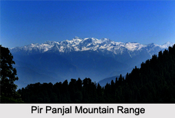
 The Pir Panjal Range is a group of mountains in the inner Himalayan region, the largest in the lower group of the majestic Himalayas. It lies south of the main outer Himalayan chain of mountains.
Extension of Pir Panjal Range
Pir Panjal Range extends from the Nilam River in western Azad Kashmir (Pakistan-administered), running southeast through the Indian state of Jammu & Kashmir to the upper Beas River in the north-western part of Himachal Pradesh. Running from the west-northwest direction to east-southeast direction, the Pir Panjal Range covers a distance of more than 200 miles or 320 kilometres.
Elevation of Pir Panjal Range
The Himalayas show a gradual elevation from the Dhauladhar and Pir Panjal ranges. The Pir Panjal Range rises sharply to an average altitude of 4,000 metres (13,000 feet), separating the Jammu hills to the south from the Kashmir Valley, beyond which lie the Greater or Higher Himalayas. The famous Murree and Galliat mountains are located in this range.
Peaks in the Pir Panjal Range
Deo Tibba and Indrasan are the tallest peaks in the Pir Panjal Range, elevated up to 6,001 metres and 6,221 metres respectively. They lie in the eastern part of the mountain range and are approachable from the Parvati-Beas valley in the Kullu district and the Upper Chenab valley in the Lahaul and Spiti district of Himachal Pradesh.
The popular and beautiful hill station of Gulmarg in northwest Kashmir of India is located in this range.
Passes at Pir Panjal Range
The major passes in the Pir Panjal Range include the Pir Panjal pass due west of Srinagar, at 3,494 metres (11,462 feet). The range follows the southern rim of the Kashmir Valley to the Banihal Pass. The Banihal Pass at the top of the Jhelum River stands at about 2,800 metres (9,000 feet), on either side of which Banihal and Qazigund towns are situated. The Sinthan Pass links the Kashmir Valley with Jammu through Kishtwar.
 Other passes in the range are the Rohtang La at 3,978 metres towards the eastern end, connecting Manali in Kullu Valley to Keylong in Lahaul valley.
Major Tunnels in the Pir Panjal Range
The Banihal Road Tunnel is a major road tunnel through the Pir Panjal Mountain under the Banihal Pass connecting Banihal and Qazigund on either side of the mountain. The existing one is 2.5 kilometres long called Jawahar Tunnel, named after the first Prime Minister of India Jawaharlal Nehru. At an altitude of about 2,100 metres, this road tunnel ensures a snow free passage to travellers throughout the year. With the overcrowding of vehicles passing through, a new longer and wider tunnel project is under implementation. It is 8.45 kilometres long twin-tube tunnel, the construction of which began in 2011. At a lower elevation, it also reduces the vulnerability to snow avalanches while also lowering the distance between the two towns by 16 kilometres.
Another important road tunnel is the Rohtang Road Tunnel being built under the Rohtang Pass at the eastern side of Pir Panjal range, on the Leh-Manali highway. Being 8.8 kilometres in length, this tunnel will be the longest road tunnel in India. The tunnel is estimated to reduce the distance between Manali and Keylong by about 60 kilometres.
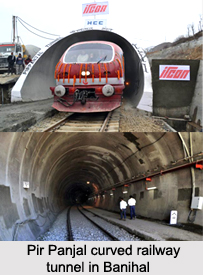
The country"s longest and Asia"s third longest railway tunnel is in the Pir Panjal Range. It is the Pir Panjal Railway Tunnel or Banihal Railway Tunnel in Jammu & Kashmir, about 11.25 kilometres long. Started in 2013, it also connects Banihal and Qazigund.
The Pir Panjal Range detaches itself from the Himalayas near the bank of Sutlej River, from where it segregates Beas and Ravi rivers on one side and Chenab River on the other.


