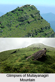
 Mullayanagiri, also known as Mullainagiri, is a beautiful peak nestled in the Karnataka state of India. With an altitude of 6,330 ft (1,930 m), Mullayanagiri is the highest peak in the state of Karnataka. It lies between the Nilgiris and the Himalayas. Mullayanagiri is a paradise for the trekkers and bikers. Ancient caves and temple are the other highlights of the mountain. Every year, the scenic beauty of this mountain lures adventure enthusiasts and explorers from various corners of the world.
Location of Mullayanagiri Mountain
This tallest mountain is located in the Baba Budan Giri Range that lies in the Western Ghats, in the Chikkamagaluru District of Karnataka. The geographical co-ordinates of Mullayanagiri Mountain are 13 degree 23"26"N 75 degree 43"18"E.
Attractions of Mullayanagiri Mountain
There are various spots in and around the mountain that are worth visiting. It is home to a temple of Lord Shiva which is situated at the top of the mountain. Close to the temple, there is also a statue of Nandi Bull. There is a cave in the nearby area as well, where there is a small water source.
There are several places for the tourists to visit, which are located near Mullayanagiri Mountain like Baba Budan Giri, Bhadra, Bisle Ghat, Abbey Falls, Kundadri Hill, Malalli Falls, Bylakuppe, Chitradurga, Agumbe, Kuduremukha and others.
Trekking at Mullayanagiri Mountain
Mullayanagiri Mountain is wonderful for trekkers due to its geographical features and natural surroundings. Mullayanagiri is almost 15km away from Chikkamagaluru. Private buses are available regularly that go through the base of the mountain. The trek starts from Sarpadhari and it`s a 4km trek to the summit. September to February is the best time to visit Mullayanagiri Mountain. The monsoon period should be avoided due to poor weather conditions. Also, it is advisable to undertake the trekking journey in daylight.
Connectivity of Mullayanagiri Mountain
It has decent connectivity via airway, railway and roadway. The nearest airport is Mangalore International Airport. The nearest railway stations are located at Birur, Kadur and Tarikere. The peak can be reached from Chikmagalur as it has well connectivity via road network. The buses that go towards the Bababudangiri will take one to the foothill of the Mullayanagiri.