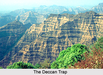
 Geography of Madhya Pradesh is divided into several geo-structural divisions. Medium highland is found in the north of the Chambal River and Son River, which is made of the Deccan Trap, Vindhya rock group, and Granite Gneiss. Steep escarpments are found in the south and southeast, which are known as Vindhyachal, Bhander, and Kaimur range. The northern parts of these escarpments have extensive plateaus. The Satpura Mountain Range is found in the south of the Narmada-Son axis, which is made up of Granite-Gneiss, Gondwana rock group and the Deccan Trap. The eastern part is known as the Maikal range. A plateau is situated in the eastern part of both the divisions of which the northern part is known as the Baghelkhand plateau, and the southern part as Dandakaranya. The first region is made up Gondwana rock group and Pre-Cambrian granite.
Madhya Pradesh is bordered by seven states of the country namely Uttar Pradesh, Rajasthan, Gujarat, Maharashtra, Andhra Pradesh, Chhattisgarh and Bihar. The present location of this state is the result of post independence and reorganisation of the state. The whole of Madhya Pradesh is a part of the Deccan Plateau. Alluvial flood plain of Yamuna River begins in the north boundary. In the west, just after the Chambal River, the Aravalli Mountain Ranges begin.
 The Chota Nagpur plateau is in the east. Similar landforms are found in the Baghelkhand plateau. The highest elevation is found in the Satpura ranges (4339 feet). The height of the Baghelkhand plateau is 1152 metres. The maximum height of the Vindhyanchal range is 881 and 150 metres elevation is found in the valley of the Mahanadi River and the Narmada River. The middle highland is a part of the Ganga Basin. The basins of the Mahanadi and the Son River are found in the east plateau. Madhya Pradesh is located to the north of the Deccan Plateau. Chota Nagpur is situated in the east, the Aravalli range in the west, the wide valley of the Tapti River is in the south and the plateau of Maharashtra is in the southwest.
Geography of Madhya Pradesh comprises three main physical divisions namely Central Highland, Satpura and Maikal Ranges and Eastern Highland. The triangular plateau between the Narmada and Son valleys and the Aravalli range is called the middle highland. It includes Vindhyan Escarpment, the Plateau of Bundelkhand, the Plateau of Central India, the Malwa Plateau and the Valley of the Narmada and the Son River. The northern boundary of the middle highland is formed by the river Yamuna. The maximum part of this plateau is the northern part of the Narmada and Son Rivers, which is a part of the Vindhyachal, Bhander and Kaimur ranges. The maximum height of the Vindhyachal hills is about 881 metres from mean average sea level. It is low towards the east. The height of the Bhander and Kaimur ranges are 752 metres and 686 metres respectively. The main rivers, which flow towards the north and join the Yamuna River, are Chambal River, Betwa River and Ken River.
 This division of central highland also consists of Vindhyan Escarpment, Bundelkhand Plateau, Plateau of Middle India, Malwa Plateau and Narmada-Son Valley. Vindhyan Escarpment is triangular plateau region. Bhander and Kaimur escarpments are found in the south and southeast. The river Son flows in the south, in parallel with the Kaimur range. The northern boundary of the plateau is the Vindhyan escarpment. On the way to Allahabad from Rewa district, there is a downward slope. The northern escarpment is continued by the Parma range, which extends up to Sagar in the southwest. The middle land of the Vindhyan escarpment is plain plateau, where streams deposit soil. This part is composed of the plateaus of Sagar, Damoh and Rewa. There is widespread land where stony soil is found in the surface. All the soil-dominated regions are characterised by agricultural practices. While forest is found in the stony land there are some patches without forest. The main river flowing in this region is the Ken and its tributaries.
Further, the northern part of the middle highland is the Bundelkhand plateau, which is composed of Chhatarpur district, Tikamgarh, the maximum part of Datia and some part of Shivpuri district and Guna district. In addition, Lalitpur district, Jhansi district, Banda district and Jalon districts are also included in this plateau. This plateau is an eroded layer of Bundelkhand Gneiss of old rocks. The Yamuna River forms its boundary and in the other parts, Vindhyachal group rocks are found. The middle Indian plateau is located in the western part of the Bundelkhand plateau. This region comprises the Vindhyan rock group. This is separated by the Aravalli ranges in the west as a frontier fault. The Chambal valley is one of the main parts of this plateau, which is formed by alluvial statement. The Deccan Trap land to the south of the Narmada River is known as the Malwa Plateau. This is the western part of the Middle highland. Sagar binds this in the east. Vindhyan rocks are seen on the surface in its western part as an effect of erosion. The Vindhyan ranges are the southern boundary of this plateau. In the north, it extends up to Guna. This plateau is formed due to the solidification of volcanic explosion. Thus, the soil is black or regur soil, which is highly fertile for agriculture. In the south, black soil layer is thicker than in the north.
 Narmada-Son valley has the longest part in Madhya Pradesh, which is about 300 metres elevated from mean sea level. This is a narrow valley, which extends from the west to the northeast. Most of it is formed as an escarpment to the south of the Son valley. Flat land is also found in the Narmada valley, which is composed of dark black soil. Alluvial soil is found in the vicinity of the river while in the upper belt, red and laterite soils are found.
The second major division of the geography of Madhya Pradesh is the Satpura-Maikal Range. The Satpura-Maikal range is divided into three parts namely west Satpura range, east Satpura range and Maikal range and plateau. West Satpura range is narrow and steep slop land, which extends up to Gujarat and Burhanpur Pass on the western boundary. There are many hills found in this range. East Satpura range is quite broad. It starts from Burhanpur pass towards the east, and is further divided into several subdivisions. The northern part of the Satpura range is quite broad. This part is called the plateau of Maikal. The eastern boundary is a crescent, which extends towards the south and this part is known as the Maikal Range. The average height is 900 metres. The upper layer of this range is plain. This layer is covered with vegetation. The ground floor grasses are also grown in this layer. This range is the source of many streams, which flow in different directions. This range is made up of the Deccan Traps. The Narmada and Son rivers originate from the Amarkantak plateau, which is part of this range. Geography of Madhya Pradesh also includes a moderate climate. Mostly residual soils are found in the state.


