Introduction
Barpeta district is one of the administrative districts of Assam. Headquarters of this district are situated at Barpeta. The Barpeta district covers an area of 3245 sq km. Barpeta is popularly known as the `Land of the Satras`. This Lower Assam District is bounded by international border of Bhutan in the north, Nalbari District in the east, Kamrup district and Goalpara districts in the south and Bongaigaon district in the west. The Barpeta District lies between latitude 26 degrees 5 minutes north to 26 degrees 49 minutes North and longitude 90 degrees 39 minutes east to 91 degrees 17 minutes East.
History of Barpeta District
History of Barpeta district narrates the tale of Koch King Naranarayan who founded Barnagar (Sorbhog) The Barpeta District formed an essential part of the Koch-Hajo and the Ahom Kingdom till British Administration took over. Barpeta district witnessed the rule of several dynasties like the Varman Dynasty in Assam, the Salasthamas, the Pala Dynasty, the Kamatas and the Koches. Barpeta is also known as Tatikuchi, Porabhita, Mathura, Vrindavan, Choukhutisthan, Nabaratna-Sabha, Icchakuchi, Pushpak Vimana and Kampur.

Major historical developments in the Barpeta district took place during the Kamata and Koch rule. During this period, large number of local feudatory-chiefs who are primarily land-lords called `Bhuyans` ruled the region. A number of villages constituted a `Chakla` placed under a Bhuyan was patronised by the Kamatas. These Bhuyans arrived from eastern part of India like Kanauj, Gauda and Bengal. With the passage of time, they became general Assamese caste and accepted the Vaishnavism faith under the influence of Shrimanta Sankardeva. Koch King Naranarayan established his temporary capital at Barnagar. Here he met Shrimanta Sankardeva and his renowned disciple and subsequently accepted Vaishnavism when Sankardeva was invited by the monarch to Koch Bihar district in West Bengal.
It was during King Naranarayan`s regime at Barnagar the great saint established Satra at Patbaushi to spread his socio-religious faith. The Koch rule ended with annexation by the Mughals. The courageous Ahom fought a number of battles against the invading Mughals. Some of the well-known battles were fought at Jakhlikhana, Bhabanipur and Bhatekuchi. Ahoms were defeated and Mughals took over the administration and systematised the entire revenue administration. Kamrupa became a Sarkar, which was divided into Parganas. A "Gomasta" was appointed to run the `Tapa` and a number of `Tapas` became a Pargana. For administrative convenience the Parganas were divided into Taluks, lats and villages. Parganas were placed under Barbaruas and Choudhuries. Taluks remained under Talukdar. They were assisted by Thakurias, Patwaries, Kakati, etc. who kept the revenue accounts. Judges in Parganas were called Shikdar, whereas Amin and Kanango were responsible for land-survey, assessment and collection of revenue.
With the advent of Shrimanta Sankardeva, this region turned into a religious place dotted with numerous satras. Further, Barpeta town came to be called `Boikumthapuri Dham. As a part of providing patronage to various religious-places irrespective of religions, the Ahom rulers provided a large number of land grants to the Satras. Widespread destruction of life and property took place when the Maans invaded from Myanmar. Even the Barpeta Satra was demolished during this invasion. To restore peace, British army entered Barpeta to drove-off all the invaders. With the advent of British rule, Mouzadari system came into effect. As a part of policy of exploitation, land-revenue rates were suddenly enhanced. The Lachima uprising is one such example of peasant revolt against the British rule. Raijor Sabha constituted during this period raised the banner of revolt. During the struggle for independence, large numbers of people participated and were imprisoned. Mohan Chandra Barman and Rauta Koch were first martyrs to sacrifice their lives during Quit India Movement of 1942.
Barpeta District was carved out of the former Kamrup District of Assam in July 1983. This district derived its name from the headquarter town of Barpeta. It was created as a Civil Sub-Division in the year 1841 by the British Administration; John Batlor was the first administrative Officer of erstwhile Civil Sub-Division. Today this district consists of two Civil Sub-Divisions and these are Barpeta and Bajali. Barpeta district has always been a place of huge religious importance.
Geography of Barpeta District
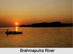
Geography of Barpeta District varies from low-lying plains to highland having small hillocks in the southwestern corner of the district, namely Baghbar, Fulora and Chatala overlooking the scenic and mighty Brahmaputra River.

The climate of Barpeta remains mild and pleasant round the year. Tropical monsoon climate of this district provides two distinct seasons - hot weather season and cold weather season. The summer season of March to May is followed by the Monsoons from June to September. This is followed by cool winter season from October to February.
River Brahmaputra flows from east to west across the southern part of the Barpeta district. The tributaries of this river that flows through this district are Beki, Manah, Pohumara, Kaldia, Palla, Nakhanda, Marachaulkhowa and Bhelengi flowing from North to South. Rivers Pohumara and Kaldia join near Barpeta town to form river Nakhanda whereas Palla and Beki join with Nakhanda to ultimately form Chaulkhowa River. The soil of Barpeta district may be classified as Sandy, Sandy-loamy and forest-soils. The Barpeta District of Assam covers an area of 3245 square kms and is bounded by international border that is Bhutan Hills in the North, Nalbari District in the East, Kamrup district and Goalpara District in the South and Bongaigaon District in the West. The district is located between latitude 26 degrees 5 minutes North - 26 degrees 49 minutes North and longitude 90 degrees 39 minutes east - 91 degrees 17 minutes East.
Barpeta District basically involves large low-lying plains having small hillocks specifically in the southwest part. The major streams of this river flowing through the Barpeta district are Beki, Manas River, Pohumara, Kaldia, Palla, Nakhanda, Marachaulkhowa and Bhelengi. The climate of this district is mild and pleasant throughout the year. The Barpeta district has Tropical monsoon climate providing two distinct seasons mainly summer and winter.
Thus, the geography of Barpeta District is spread over vast plain lands with some hillocks in between.
In this district there are major town. These are famous for tourist attraction and also the easy means of communications.
Barpeta: The headquarter and the second largest town in the district. It is virtually a noise and pollution free town with a limited number of automobiles. Rivulets and canals from all directions surround the town. The most important centre of attraction is the Barpeta satra established by Great Vaishnavite saint Madhabdeva. A few years ago, it was also famous for transport industry. However, it has faded a little bit now. It was also famous for ivory working, which is now almost extinct.
Howly: Howly is the largest town of the district. A busy commercial town is also known as the business capital of the district. In this town, Assam`s largest Rash Mela held here. Many communities of people of Assam participate in this Rash Mela. The National highway No 31 runs through this town. A majority of the people in the town have higher education. It is the only town where betel nut (Supari) produce. Many betel nut industries situated here.
Barpeta Road: Barpeta Road is the largest town of the district. A busy commercial town is also known as the business capital of Western Assam.
Sarbhog: A small town along national highway no. 31 that is known for its famous tasty curd made from buffalo`s milk. Many institutions are located in and around the town.
Pathsala: A town in the eastern part of the district is also known as the Hollywood of mobile theatres of Assam. Base camps of many famous and old mobile theatre groups of Assam are situated in the town. A majority of the people in the town have higher education.
Barmara: A small village situated as a transit point between Chenga and Rouly. It is known for its biweekly markets that cater to all the needs of poor and lower middle class people.
Sarthebari: Sarthebari is a small town known for its bell-metal works.
Kalgachia: A town situated in the western part of the district, mainly inhabited by Bengali-speaking Muslim people. It is an important centre of academic and intellectual activities of Bengali-speaking Muslim people of Assam.
Bhawanipur: A town situated near NH31 and the centre place of Barpeta District. It has a good Communication System for the people. It is a well-educated and well-populated town. Mainly Hindus and members of the Muslim community live in the town. The town is known for Bhawanipuria Gopal Ataa Satra and for Sahid Khargeswar Talukdar.
Sarupeta: Sarupeta is a town situated near Bhawanipur Town. It is mainly known as place of business.
Barbhitha: Barbhitha is a small village on the south- west border of the Barpeta District. The specialty of the village is that there is at least one master degree holder in every family. One of the pioneer e-entrepreneurs from North East India, Main Uddin, was also born in this village.
Demography of Barpeta District
According to the Population Census in 2011, Barpeta District had a population of 1,693,190 of which male and female were 867,891 and 825,299 respectively. The population of Barpeta District constituted 5.43 percent of total population of Assam. The population density of Barpeta district is 632 people per sq. km. Barpeta district administers 2,679 square kilometres of areas. The average literacy rate of Barpeta District is 65.03 percent. If things are looked out at gender wise, male and female literacy were 70.72 and 59.04 respectively. The total literates in Barpeta District were 918,708 of which male and female were 512,330 and 406,378 respectively.
Culture of Barpeta District
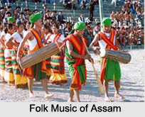
Culture of Barpeta district is reflected by the marvellous creations of Srimanta Sankardeva, the renowned Assamese renaissance personality and social reformer. He is credited for establishing the founding stone of the rich culture of the Eastern Indian state of Assam. Thereafter, some famous saints like Damodardeva, Madhabdeva, Harideva and their disciples became followers of the excellent works of Sankardeva.

Satras
These noted saints founded numerous `Satras`, which were cultural hubs or monasteries that were known to influence the political and socio-economic sectors of this state. Initially, these satras were set up with view to propagate the fundamental principles of the Vaishnavite faith. However, as time progressed, these institutions metamorphosed into universities which imparted education and training in several fields like music, dance, education, drama, sculpture, Ivory craft, fine arts and many more. Significant satras include 'Kanara', 'Jania', 'Patbaushi', 'Barpeta', 'Ganakkuchi', 'Baradi', 'Sundaridia', etc.
Patbaushi Satra
Shrimanta Sankardeva had established the Patbaushi Satra and the faith of Vaishnavism was circulated by his capable disciples like Shri Hari Deva, Shri Madhav Deva and Shri Damodar Deva. Shrimanta Sankardeva is believed to have spread his literature, culture, faith, various forms of arts, and work ethics to a great extent. It was at this very place that Srimanta Sankardeva is said to have spent 18 years of his life and composed 20 famous `Borgeets` and finished creating the `Kirtan Ghosa`. Many items utilized by these saints, as well as Sachipat `puthis` are conserved in this satra which is located at a distance of 2 km from the northern part of the town of Barpeta.
Ganakkuchi Satra
Sri Madhab Deva had established the Ganakkuchi Satra. Legend says that the land for this Satra was bought for 1 tola which equals to 10 grams, by Sankardeva. Madhab Deva was appointed the `satradhikar` who had to reside at this place in order to propagate his faith. Madhab continued to stay at this Satra for as many as 18 longs years. This Satra is situated inside Barpeta town. The Sachipat `puthis` and many objects utilized by Madhab Deva have been preserved at the Ganakkuchi Satra.
Jania Satra
Shri Narayan Das Thakur Ata, who was the disciple of Sankardeva had founded this Satra. Innumerable devotional songs were composed at Jania Satra. Jania Satra is present within 8 km from Barpeta town, in Barpeta Jania Road.

Sundaridiya Satra
After Shri Madhab Deva had left Ganakkuchi Satra, he established the Sundaridiya Satra. Sri Mathura Das Burha Ata, who was the first satradhikar of Barpeta Satra. Following his arrival to this Satra, Mathura Das became a disciple of Madhab Deva. Sri Madhab Deva had created Paal Nam and Thiya Nam or Beer Nam. Like the other Satras, this Satra also contains the items used regularly by these gurus and even the Sachpat puthis.
Barpeta Satra
This Satra was established by Sri Madhab Deva, who inhabited this Satra for 8 years. Sri Mathura Das Burha Ata was appointed the first Satradhikar of the Barpeta Satra. This Satra attracted numerous followers who embraced the faith of Vaishnavism, irrespective of caste or creed. This Satra comprises many buildings and its main front gate is termed as the 'Batsora'. 'Nam Kirtan' or prayers are performed in this Satra, in the `Kirtanghar`. Devotees assemble in `Jagmohan Ghar` and discuss their anxieties collectively. The Three Guru Asanas are placed in these buildings in honour of Shrimanta Sankardeva, Shri Madhavdeva and Shri Badula Ata. The two Satradhikars sit behind the Asanas to hold Nam-Prasangas regularly.
For over 400 years, a `Bhajghar` constantly glows and it is termed as the `Akhay Banti`. In the `Doul Ghar`, the festival of Sri Krishna Doul is celebrated. A `rangial` garden and a zoo are present in the premises of this Satra. Shri Shri Mathura Das Burha Ata Library, Keli kadam tree, kitchen, office and study room also exist in the premises of Barpeta Satra.
Baradi Satra
Shri Madhab Deva had stayed at Baradi Satra for a brief period. This Satra boasts of a rich Sanskarite culture and is located at a distance of nearly 2 km from the eastern part of the town of Barpeta.
Kanara Satra
Sri Sri Nayarana Das Thakur Ata had founded the Kanara Satra. However, today natural disasters have been responsible for the destruction of this Satra. Therefore, the original settlers of this Satra migrated to Ganakkuchi Satra and Gajia in Barpeta town. It is based about 16 km from Barpeta.
Tourism in Barpeta District
Tourism in Barpeta District has become popular with the establishment of several satras by the followers of Shrimanta Sankardeva (great Vaishnava saint). This advent contributed tremendously in the transformation of Barpeta region into a place of great religious importance. These Satras are a major attraction point as far as the tourism of Barpeta district is concerned. It attracts a large number of devotees from all over the state, particularly during several significant festivals and anniversaries. Among the Satras, which are regularly visited by the travellers are Barpeta, Patbaushi, Ganak Kuchi, Sundaridiya, Sunpura, Satra Kanara and Jania.
Some of the significant tourist attractions of Barpeta District are as follows:
Barpeta Satra: The buildings within the Barpeta Satra premise are considered as architectural achievements in its own right. Its Kirtan Ghar is considered to be the largest in Assam. Chinpara Vithi is the place where Srimanta Sankardeva landed from his boat at Barpeta on banks of Bori River; which is presently called Palangdihati. The Saint stayed here for six months to propagate his faith. This place is located around half km north of Barpeta Satra. The Namghar established by the Guru still exist.
Sundaridiya Satra: Shri Madhavdeva founded the Sundaridiya Satra and composed the `Bhakti Ratnakar` and `Namghosa` here. The great saint during his vacation here dug a well that is preserved till today and people consider the water of this well holy. Three Guru Asanas are placed in the name of Shri Sankardeva, Shri Madhavdeva and Shri Badula Ata.
Patbaushi Satra: Patbaushi Satra is frequented by large number of devotees and visitors as it was a cultural centre from where Satriya culture, art forms and literature spread far and wide. The scripts are carefully preserved here. Further, the state government has taken steps for preservation of these treasures of Assamese heritage and planning to setup a Shrimanta Sankardeva Museum at the premises of the Satra. The Damodar deva Satra is also located in the same premises.
Pari Hareswar Devalaya, Dubi: This temple is dedicated to Lord Shiva. The famous dance form `Devadasi Dance` is said to have originated in this Temple.
Dargah of Syed Shahnur Dewan, Bhella: A disciple of Muslim Sufi-Saint Ajan Fakir of Upper Assam came and stayed at Bhella region to spread the Sufi Philosophy.

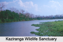
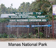
Manas National Park:
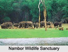
Declared as a national park in the year 1990, Manas National park is located at Himalayan foothills where it is having unique bio diversity and scenic landscapes. It is one of the first reserves included in the tiger reserve network under project tiger in 1973. It is covering an area of 2837 sq. kms. Manas River flows through the park with unique blending of dense forests; it harbours the largest number of protected species of India including Royal Bengal tiger, leopard, buffalo, peacock hog, golden langur, Assam roof turtle, and more. This park is included as a site of international importance under UNESCO`s world heritage convention in 1988 as well as Biosphere Reserve in 1989. There are as many as 60 species of mammals, 312 birds, 42 reptiles, 7 amphibians, 54 fishes and more than 100 species of insects in this park. The place can be easily reached from Barpeta Road, which is located at a distance of 20 kms. It is well connected with the rest of the country through proper railway services and Lokpriya Gopinath Bordoloi International Airport at Guwahati is nearly 160 kms from Barpeta Road. However, visitors are required to obtain necessary permission for entry into this park from the Field Director of this park.
Brass Metal Industry of Sarthebari:
Sarthebari town is located in the easternmost corner of the Barpeta district and is renowned for the household brass metal industry. It expertises in making Sarais, Bota, Ban-Batis, Thals, glasses and more such things that are traditionally used by the Assamese people. These utensils are unique contribution towards Assamese tradition and culture carried for long period of time. However, due to increasing cost of raw materials that is to be imported from other state, the artisans are finding it economically difficult to continue the industry.
Apart from these attractions, tourism in Barpeta District also include several magnificent sightseeing options mainly river side views. The main rivers of Barpeta namely Manas River, Beki and Brahmaputra River present scenic beauty that offers an enriching tranquil experience. A visit to Baghbar hills also provides a scenic overview of the mighty Brahmaputra River. But, this district needs some developments in infrastructural facilities to enhance its tourism.
Visiting information
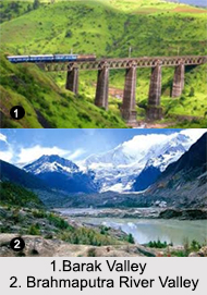
Barpeta District is well connected by road and train services. The nearest Railway Station is Barpeta Road that lies at a distance of 21 kms from Barpeta Town. Barpeta Road is connected to all over the state. There are regular bus services between Barpeta and Guwahati.