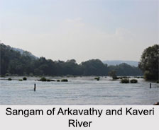
 Arkavathy River, an important mountain river in Karnataka, originates at Nandi Hills of the district of Chikkaballapura. It joins its tributary river Kaveri at 34 km south of Kanakapura, Ramanagara District. That place is called Sangama in Kannada. Arkavathy River channels into the Chikkarayappanahalli Lake close to Kanivenarayanapura. Kumudavathi and Vrishabhavathi rivers are tributaries to this river. Arkavathy River forms Chunchi falls near Haroshivanahalli. The total length of the Arkavathy River is 190 kilometers.
Arkavathy River is utilized by the Bangalore Water Supply and Sewerage Board to give 135 million liters of drinking water every day to the city of Bengaluru. The water of the river is fresh and extremely clean due to the filtering process in the nearby mountain aquifer. The water is taken from two reservoirs based on the river. One is Hesaraghatta, built in 1894, and the other one is Tippagondanahalli Reservoir, built in 1933.There is Manchanabele dam across the river, which is situated in Ramanagara District.


