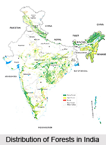
 Distribution of forests in India is such that 22.09 percent of its biographical area is under forests. The concentration of forests is the highest in Central and Eastern India. Variation among States is wide. The least forested state is Haryana and the most forested state is Arunachal Pradesh. Among the Indian Union Territories, Andaman & Nicobar Islands has the highest percentage of forest. Most of the Union Territories have a sizable area under forests. A look at the different zones of Indian territories reveals a clearer picture.
It is difficult to identify zones as water tight compartments. Soil moisture and climatic conditions predominantly influence distribution of forests. But they establish a complex pattern gradually changing over the area. The zones in this case should be taken as discrete, and to some extent arbitrary, subdivisions of the Indian-geographical area. Boundaries have been coincided with those of state as far as possible. Keeping these factors in mind, the eastern zone consists of Eastern zone consists of Sikkim, Arunachal Pradesh, Assam, Meghalaya, Nagaland, Manipur, Mizoram, Tripura and Andaman and Nicobar Islands. The Northern zone consists of Uttar Pradesh, Bihar, Jharkhand and West Bengal. The Western zone consists of Jammu and Kashmir, Himachal Pradesh, Punjab, Haryana, Rajasthan, Gujarat and Delhi. The Central zone encompasses Madhya Pradesh, Chhattisgarh, Orissa, Maharashtra and Dadra and Nagar Haveli. Andhra Pradesh, Karnataka, Tamil Nadu, Kerala, Goa, Daman and Diu, Lakshadweep and Puducherry constitute the Southern Zone.
 The distribution of forests in these different reveals a lopsided distribution. Western and Northern India are the most deficient in forests. For the general populace, forests symbolise timber supply. The markets see forest as a source of timber. For this reason there is a tremendous traffic in timber from eastern to northern and western India. In contrast to the distribution of forests in these areas, it is actually the forests in the eastern zone which make up the bulk of forests in India. If the eastern zone were to be excluded it would bring the actual percentage of forests down to 15.40 percent of geographical area. Close to one fourth of the forests in the rest of India lack tree cover.
The moisture conditions in the Eastern zone are conducive to luxuriant forest growth. Woody vegetation encroaches unused fertile lands. Close canopy forests are natural. Only 56 percent of its existing forests contain crown density more than 0.4. In natural forests, it roughly corresponds to regenerating tree stands. It symbolizes presence of seedlings, saplings and poles in appropriate ratio. It roughly indicates absence of biotic interference. It also signifies, at least equilibrium, between forest regenerating and forest degrading forces. Only arid western zone has a lower value (52 percent) than this. Given the far more conducive climatic conditions in the Eastern zone than those in arid Western Zones, this is a real cause of concern.
There are a number of degrading forces in the forest area which contribute to the density of their distribution. The forest degrading forces are proportional to the ratio of density of forests to total forest cover. The product of per capita forests and ratio of degraded forests to total forest cover is an index of the dimensions of degrading forces. It is seen that degrading forces vary widely. Degrading forces in Eastern Zone are higher than those in Northern Zone. This is a cause of concern. Even in the Central zone degrading forces are higher than those in Northern zone. Central zone contains the greatest chunk of close canopy forest. Degrading factors here, too, need serious consideration. As per Indian Forest Act, 1927 the reserve forests have the most stringent control on the forests land. Very high reservation of forests in Northern Zone is reflected in the weakest degrading force here. The least extent of reservation in Eastern region is reflected in the most severe degrading forces here. Central zone contains the greatest percentage of close canopy forest. Their reservation reflects poor progress. Others present mixed trends.


