Introduction
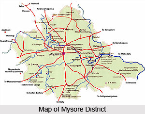
Mysore District is situated in the Southern part of the Deccan plateau in the state of Karnataka. It is an undulating tableland, covered in part by granite outcrops and at the same time fringed with verdant forests. Since the days of kings and palaces, this district has played a rather significant role in the history of South India.
History of Mysore District
The earliest known reference of rulers in Mysore district are the Western Ganga Dynasty who during the rule of King Avinitha (469-529 CE), moved the capital from Kolar to Talakad on the banks of the river Kaveri in the Tirumakudalu. Later in the early phase of medieval period, the Chola Dynasty came into existence and in the later phase of medieval history Hyder Ali and Tipu Sultan came in power.
Geography of Mysore District
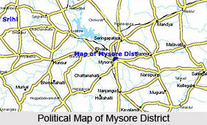 Mysore district lies in the southernmost part of Karnataka in the Southern maidan region. The region in which the district is found may be classified as partly maiden and partly semimalnad (malnad hilly lands).
The district forms the southern part of the Deccan peninsula with Tamil Nadu to its southeast, the Kodagu district to its west, Mandya district to its north, Hassan district to its northwest and Bengaluru district to its northeast. It lies at an altitude of 610 metres from the mean sea level. The district covers a total geographical area of 6, 76,382 hectares of which 62,851 hectares constitutes the forest land. The net cultivable land is 4, 86,410 hectares and of this 1, 14,010 hectares of land is irrigated.
The prominent river of the district is the Kaveri River. Mysore district is considered as one of the prosperous district of the state based on the development and utilization of irrigation facilities, abundance of forest wealth and sericultural products.
Mysore district lies between 11 degrees 30 minutes to 12 degrees 50 minutes North latitudes and 75 degrees 45 minutes to 77 degrees 45 minutes East longitudes. Mysore district is an undulating tableland with granite rocks protruding at odd intervals. The mountain ranges in the district originate from the Nilgiris along its southern borders and runs in a northwest and northeast direction. There are the Ghats and, in between them lies the Mysore plateau, which is enplane. Except in the north, the district is almost entirely surrounded by the Western Ghats mountain range which at places is an elevation of more than 1200 meters above the mean sea level. Only along the southeast, the mountain ring is broken, where the river Kaveri takes its course towards the Ghats and plunges into the famous Gaganachukki and Barachukki falls at Shivansamudram.
Geologically, the district is mainly composed of igneous and metamorphic rocks either exposed at the surface or covered with a thin mantle of residual and transported soils. The rock formation in the district falls into two groups, charnockite series and granite genesis and gneissic granite. The climate area is agreeable. The climate of the district may be described as essentially tropical monsoon type which is a product of the interplay of the two opposing air-masses of the southwest and northeast monsoons. Over the greater part of the district, summers are languorously warm and winters bracingly cool. The four main seasons applicable to the district are the Cold Weather season, the Hot Weather Season, the South-west Monsoon and North-east Monsoon.
The district in general enjoys cool and equable temperatures. April is the hottest month with the mean daily maximum temperature at 34.5 degree Celsius and the daily minimum at 21.1 degree Celsius. On normal days, the day temperatures during summer may exceed 39 degree Celsius. With the advance of the southwest monsoon about the beginning of June, the day temperatures drop appreciably and throughout the southwest monsoon period, the weather is pleasant. After mid-November, both day and night temperatures decrease progressively. January is the coldest month with mean daily maximum at 11 degree Celsius.
The soils of the districts can be broadly classified as the laterite, red loam, sandy loam, red clay and black cotton soils. The laterite soil occurs mostly in the western part of the district while the red loam is found in the northwest. These two account for nearly half the area of the district. The black cotton soil is found mostly in the north-eastern parts of the district. The red soils are shallow to deep well drained and do not contain lime nodules. The black soils are 1 to 1.5 metre in bases with good water holding capacity for a longer time.
Mysore district is the third richest in forest wealth in the State. The area covered by forest is 4,126.45 sq. km, 34.52 per cent of the total area, of which 3,875.6 sq. km, are reserved forest, and 250.9 sq. km. are classified as forests.
Mysore district has two types of forests and they are moist deciduous where the rainfall is 900-1100 mm and dry deciduous where the rainfall is 700 - 900 mm. The forest belt in the district begins from the western part of Hunsur taluk, spreads along the border of Kerala and Tamil Nadu into the south and east.
The Principal species of trees in the forests are teak, honne, rosewood, dindiga, eucalyptus and sandalwood. The major produce of the forests in the district consists of teak, matchwood, sandalwood, rosewood and building materials. Indirectly, forests of the region confer various ecological benefits on the land such as salubrious climate and good rainfall. They are above all ecosystem habitats.
Economy of Mysore district
Mysore district is the third richest in the forest wealth of the state. There are basically two types of forests found here. These include the moist deciduous where the rainfall is 900-1100 mm and dry deciduous where the rainfall is 700 - 900 mm. The Principal species of trees in the forests are teak, honne, rosewood, dindiga, eucalyptus and sandalwood. It is only in the hilly areas, there is however a resemblance of evergreen forests. The major produce of the forests in the district consists of teak, matchwood, sandalwood, rosewood and building materials. Over and above everything else, these forests are ecosystem habitats.
Administration Of Mysore District
 Administration of Mysore district in Karnataka is carried out by the Deputy Commissioner. The Office of the Deputy Commissioner is headed by the Deputy Commissioner and the District Magistrate (Revenue Department). The Deputy Commissioner is in charge of the general administration of the entire district and he is responsible for maintaining law and order in the district. The Deputy Commissioner, being the head of the district administration, is perhaps the only officer who exercises powers under the largest number of laws both state and central. The Deputy Commissioner is assisted by the Head Quarters Assistant. He is the head of the Revenue district. Mysore Revenue district is divided into 2 sub-divisions headed by Assistant Commissioners. These sub-divisions are comprised of talukas headed by Tahsildars. Taluks are further divided into hoblis headed by Revenue inspectors. These hoblis are comprised of villages. Groups of villages are formed into Village Accountant circles. Village Accountants maintain revenue records and it is their duty to collect revenue and other dues. The Administrative Section directly assisting the Deputy Commissioner in his office is headed by the Office Assistant of the rank of Tahsildar.
The functions of the district administration can be briefly summarised as follows:
Law and Order and Magisterial Matters: This group of functions relates to public safety and tranquillity. Maintenance of Law and order is the joint responsibility of the Superintendent of Police, who heads the Police force in the district, and the District Magistrate. The Deputy Commissioner of the District is also the District Magistrate. Though there is a separate department for the administration of jails, the district Magistrate exercises general supervision over the Jails in his district, citizenship matters or arms licences, cinema, NOC for petroleum bunks and storage for LPG cylinders.
Land Revenue: The second group of functions relates to revenue administration. While the most important component of this group is land administration including maintenance of land records, it also includes the assessment and collection of land revenue and other Government dues which are collected as arrears of land revenue. The Deputy Commissioner is a designated Revenue officer in various laws governing the land to deal with disputes arising out of land records and management of public lands and properties. The other revenue officers, namely, the Assistant Commissioners, the Tahsildars and the Deputy Tahsildars also perform functions of dealing with land disputes under the overall supervision and control of the Deputy Commissioner.
Development Activities: Schemes like MPLAD, MLAD, Ashraya, and Calamity Drought are being implemented by the Deputy Commissioner.
Election: The Deputy Commissioner is the District Election Officer. He is the Returning Officer for the Parliamentary Constituency, South Teachers Constituency/ South Graduate Constituency. All other elections namely, elections to the following, such as the elections to the Assembly Constituency, Town Municipal Council, Town Panchayat, Zilla Panchayat etc are held under the supervision of the Deputy Commissioner.
Census: The Deputy Commissioner is the District In charge of the census operations conducted once in 10 years, including the Cattle Census, Agriculture Census, Irrigation etc are conducted.
Municipal Administration Matters: The Deputy Commissioner is generally responsible for the supervision and proper functioning of the urban local bodies. The implementation of various developmental and anti-poverty measures for the urban poor is monitored by the Deputy Commissioner. The most important of these programmes are the Swarnajayanthi Shahari Rozgar Yojana (SJSRY), Urban Ashraya (Housing), Twelfth Finance Commission development grants, SFC and the JNNRUM for Mysore city.
Emergency Relief: In situations like floods, famines, accidental fires, earthquakes and other natural calamities, the entire district administration headed by the Deputy Commissioner, the Department like Police, Revenue, Health, PWD, Fire Force, Home Guards etc., all of whom are geared to meet the contingencies. General Public and the farmers can seek relief from the Revenue Department.
Land Acquisition matters: Acquisition of land for public purposes like construction of development projects, roads, bridges, irrigation channels, industries etc. is carried out by the Land Acquisition Officers under the control of the Deputy Commissioner.
Residuary functions: There are a number of executive functions of Government which have not been precisely defined and there is no separate representative of the Government to carry out such duties in the district. It is the DC, in his capacity as the chief representative of Government in the district, who has to deal with all residuary matters. This group of activities includes miscellaneous functions like Family Planning, Red Cross, District Social Welfare Schemes, Excise, Backward Class and Minority Schemes other Departmental Works. He is the inspecting authority for other department offices, except Police and Judiciary. This is the organisation of administration in the district of Mysore.
Tourist Places in Mysore Districts
 Tourist places around Mysore or Mysuru include some prominent palaces which define the traditional background of the city of Mysore.
The city of Mysuru is one of the ancient cities of India which is based on the legends of Goddess Durga and her fight with Mahi Shasur, a terrible demon (Demon Mahisha) who was vanquished by Goddess Durga. Some of the popular tourism destinations near Mysore or Mysuru are Chamundi hill, Krishnarajasagar Dam, Brindavan Gardens, Ranganathaswamy Temple, Himavad Gopalaswamy Betta, Mudumalai Wildlife Sanctuary and Bandipura National Park.
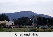
Chamundi Hill
 Chamundi hill is located just behind the city of Mysore or Mysuru. With an average elevation of 1000 metres, this hill is located 13 kms from the Mysuru. According to the legend of the area, the notorious demon Mahishasura, who used to rule this area which is presently known as Mysore or Mysuru. He was killed by Goddess Chamundeswari (also Known as Chandi) after the tremendous war which is mentioned in the texts of Chandi.
Shirangapattam
The historic city of Shirangapattam was the erstwhile capital of Tipu Sultan`s Empire. The place is mainly marked by the palace of Tipu Sultan which is located between two streams of Kaveri River. The city of Shirangapattam also includes a museum, the dungeons or a dark prison located along with the palace and the tomb of Tipu`s father Hyder Ali.
Ranganatha Temple
The famous temple of Sri Ranganatha was worshipped by the ancient sage Gautama. Since then this place is considered to be one of the important place of worship located at the outskirts of Mysore or Mysuru. Besides this there is a bird sanctuary located at some distance from the Mysuru.
Ranganathittoo Wild life Sanctuary
Ranganathittoo Wild Life Sanctuary is one of the most important wildlife sanctuaries, located at a distance of 3 kms from Shrirangapattam. This place is surrounded with group of islets in the Kaveri River which attracts a large number of migratory birds towards the water bodies which leaves an aromatic view behind. 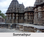
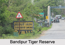
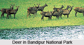
Bandipur Tiger Reserve
Bandipur Tiger Reserve is sanctuary which is located 80 kms from Mysuru. This is one of the well known tiger reserves that were developed under the Tiger Project of India.
Somnathpur
Somnathpur is located around 35 kms away from Mysore. This place is popular for the presence of the ancient temple with exquisite decorations. The architecture of the temples in Somnathpur includes 3 pyramidal dooms which are surmounted by triple shrines. These temples follow the medieval Hindu sculpture. The temples of Somnathpur are dated back to 13th century.
Shivasamudram
There is another picturesque sight for tourism- Shivasamudram. Located at a distance of 80kms this appears like an island which divided by the Kaveri River. This is well known for the two ancient temples and India`s first hydro power project that makes it valuable not only in the past but also at present.
Pilgrimage Tourism In Mysore District
 Pilgrimage tourism in Mysore district includes visiting the beautiful temples located here. These ancient temples have been constructed by the kings and rulers of ancient times and are, therefore, of immense worth from the historical point of view as well. Apart from the temples, a church is also found located at Mysore district. The various places of pilgrimage tourism in Mysore district are briefly discussed below.
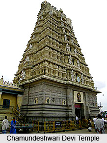
The Chamundi Hills, 3,489 feet above the sea level, is located 12 Kms away from Mysore city. Found here are a number of temples built in the days of yore. The largest and the best know is the large Dravidian Temple, dedicated to Sri Chamundeshwari Devi, the tutelary deity of Mysore, and generally regarded as an incarnation of Parvati or Durga. Her image on the hill rides a lion and has twenty hands. It is said that Raja Wodeyar (about 1600 AD) intended to build a gopura, and for that purpose erected four large pillar posts, which were removed when the present gopura was built by Krishnaraja Wodeyar III. He built a gopura with golden finials, and set up statues of himself and his 3 queens in the presence of the Goddess. In 1827 he made arrangements for festivals and processions.
The Nandi bull is found half-way up the hill. It is said to have been fashioned in a single night out of the basalt of the hill. The colossal statue, over 25 feet long and 4.8 metres high, is adorned with ropes, chains, bells and jewels of stone. The statue was a gift of Dodda Deva Raja.
St. Philomena`s Church was built in AD 1840. It was initially known as St. Joseph Chaver which later assumed the present name. The then king of Mysore, Krishnaraja Wodeyar IV, laid the foundation for the construction of the church in 1933. It has been designed by a French architect. The twin towers of this gothic-designed church stand high at 175 feet. The stained glass windows, made in France, overlooking the apse, showing the Birth of Christ, Baptism of Christ by St. John, the last supper and the crucifixion of Christ are real works of art. The altar bears the statue of St. Philomena, a 3rd century saint from Greece. The church has a cellar where there is a statue of St.Philomina in a reclining posture. A piece of her bone and clothes are kept in this church. The church is located about I km from Mysore Palace on the Bengaluru highway.
Situated in the unobtrusive village of Somanathpur, 35km from Mysore, the exquisitely carved, star-shaped Somanathapuram temple with triple towers is a perfect example of Hoysala architecture. The friezes on its outer walls with intricately carved rows of caparisoned elephants, charging horsemen, and mythological birds and beasts are bound to leave one spellbound. Beautifully sculpted images of gods, goddesses and scenes from the epics, as well as the remarkable ornate ceilings in the pillared hall are remarkably well done.
Nature Tourism In Mysore District
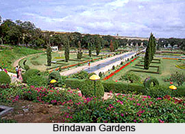 Nature tourism in Mysore district is a most pleasurable experience, as the district abounds in natural beauty. There are a number of places of nature tourism in Mysore district such as beautiful gardens, lakes, bird sanctuary etc. one of the primary tourist attractions of Mysore district is the Brindavan Gardens. These are located just a level below the Krishnaraja Sagar reservoir built across the Kaveri River.
Often described as the best example of illuminated terrace gardens in the country, the overall design here displays an orientation of Mughal patterns, with garden paths and a shimmering necklace of fountains. On the South bank there is a pavilion, where visitors can get a breathtaking view of the gardens. Other highlights at the gardens include a children`s park, a fisheries station and a hydraulic research station. Adding a touch of sanctity to the place is a beautiful sculpture of Goddess Kaveri at the foot of the dam.
Karanji Lake
Picturesquely located at the foot of Chamundi hills and adjacent to the Mysore Zoo, the Karanji Lake is a beautiful bird sanctuary in the heart of Mysore City which provides a wonderful habitat for more than 70 different species of avifauna. The recently re-developed lake, spanning across 90 acres has a butterfly park, boating, children`s corner, a watch tower and India`s largest walkthrough aviary.
 Kukkarahalli Lake
The Kukkarahalli Lake is located in Mysore University Campus. This lake has inspired many local poets and writers. The view from the north shore is particularly attractive with the lake and its surrounding trees, the spire of the deputy commissioner`s offices rising above them and the low rise of the Chamundi Hill in the background. This lake is home to more than 180 species of birds, some of them aquatic. During the migratory season the lake plays host to a variety of birds, some from as far as Siberia. There is a 4.5 km walkway on the periphery of the lake with shaded stone benches for visitors to sit, relax and enjoy the scenic serenity of the lake.
Ranganathittu Birds Sanctuary
Ranganathittu Birds Sanctuaryis located just outside Srirangapatna near Mysore, where the Kaveri River meanders around a string of tiny nesting sites of waterfowls. Available here are boat rides which take one within touching distance of the birds as marsh crocodiles bask in the sun An amazing display of flora and fauna is found in here at the sanctuary. Deciduous forests are found lining the area, with bamboo, eucalyptus, figs, Jamun and Karanji trees. Among the animals found here are mammals and reptiles such as the flying fox, bonnet macaque, common otter, common mongoose, palm civet and marsh crocodiles. Bird life includes the little cormorant, large cormorant, darter, white ibis, spoonbill, open-billed stork, painted stork, egret, heron, river term, great stone plover, kingfisher and the Indian cliff swallow.
Bandipur National park
Bandipur National park is situated about 80 kilometres south of Mysore, on the Mysore-Ooty road. The reserve is a playground for wildlife, with elephants taking the lead role. Set against the picturesque backdrop of the enchanting Niligiri Mountains with its mist-covered peaks, Bandipur was once the Mysore Maharaja`s private hunting ground. It was brought under Project Tiger in 1973. This is one of the best game sanctuaries in India to observe and photograph wildlife in close proximity.
A temple perched atop Himvad Gopalaswamy Hill, the highest peak in the Bandipur range, is worth a visit. A wide variety of species of flora and fauna are found here. The animals found here are tiger, leopard, elephant, gaur, sloth bear, Asiatic wild dog, striped hyena, sambar, spotted deer, barking deer, mouse deer, mongoose, and the slender Loris. Reptiles like the common rat snake, Russell`s viper, common krait, Indian python, flying snake and the cobra can also be seen. Over 230 species of birds have been identified nestling among the evergreen deciduous vegetation of the region. These include the heron, stork, egret, kite, eagle, falcon, peafowl, lapwing, sandpiper, woodpecker etc.
Temples of Mysore District
 The temples of Mysore district in Karnataka are not only famous in south India, but they are pilgrimages for devotees from all over the nation. The temples of Mysore district are the best specimens to study south Indian pattern of arches and architecture. Mysore District is located in the southern part of the state of Karnataka and is a tourist`s paradise with varied attractions from palaces, parks and temples. The Wodeyars from the year 1399 till the independence of India in the year 1947 ruled Mysore.
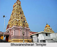
Bhuvaneshwari Temple, Narayana Temple, Sri Lakshmi Venkataramanaswamy Temple, Gayatri Temple, Sri Prasanna Seetharama Mandira and Jaganmohana Ranganatha Temple are some of the popular temples of Mysore district. Agasteeshwara Temple is a shrine of Lord Shiva situated on the banks of River Cauvery at Thirumakudal in Karnataka. According to legends, sage Agastya installed the deity. A remarkable feature of this temple is the water trickling down from the head of Lord Shiva. Thirumakudal is the holy confluence of rivers Kabini and Cauvery.
Kodi Bhairava Temple is one of the most popular temples of Mysore district. This temple stands in the compound of the Mysore Palace. The temple is known by this name, as it is located on the weir of Devaraya Sagara, a dried-up tank popularly known as Doddakere. The temple enshrines the l m high idol of the four handed Lord Bhairava holding a trident, a drum, a skull and a sword. It is flanked on the left by the image of Bhadrakali, and on the right by a female chauri-bearer.
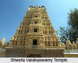 Shwetha Varahaswami Temple, an 18th century shrine, is located near the southern entrance of Mysore Palace and the presiding deity is Varaha, an incarnation of Lord Vishnu.
A fine Hoysala structure, the temple was built under the sponsorship of Maharaja Krishnaraja Wodeyar III. It boasts carved doorways, pillars and towers, apart from five-tiered Rajagopuram and the huge images at the entrance. The hall is polished with mural paintings, which represented the scenes from the Ramayana and Mahabharata, popular being the one depicting the coronation of Lord Ram. The adorned images of Srivaishnava Acharyas, Desikar and Jiyar are the added attractions.
Nimishamba Temple is one of the oldest temples of Mysore district, on the banks of river Cauvery. It is only 2 km from Srirangapatna town. This holy place enshrines the embodiment of Parvati. It is believed that the goddess here blesses her devotees every `nimisha,` meaning `every minute. Some other important temples of Mysore district include Prasanna Kesava Devalaya, Trinesvaraswamy Temple, Prasanna Krishnaswamy Temple and Yoga Narasimhaswamy Temple.
 For pilgrims who are interested in touring Mysore will definitely be pleased to know that there are pilgrimage centers around Mysore too. From the city these places are quite accessible as local transports are available to reach the temples.
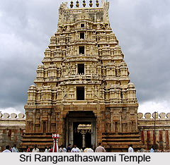
One can start the pilgrimage tour with Srirangapatnam. It is 20 km away from Karnataka. This holy town is situated in an island formed by the waters of Cauvery. Puranas speak of this place as Gautama Kshetra. The sage, who had his ashram on the banks of Cauvery, is believed to have founded the shrine of Lord Ranganatha. Historical evidence dates back to the reign of Ganga king Thirumalaiya (897 AD).
Srirangapatnam is also revered as Adi Rangam like Srirangam near Tiruchi in Tamil Nadu. It is known as Andhya Rangam.
Sri Ranganathaswami Temple: It is one of the largest temples with a massive gopuram. The Lord is seen reclining on Adi Sesha with the Goddess in His chest. The images of sage Gautama and Goddess Cauvery are enshrined at the holy feet of the Lord.
Saints and Alwars are enshrined on the prakarams. Two pillars in front of the inner entrance are called Chathurvimsati. The 24 forms of Vishnu with their names are engraved thereon.
In the northwest corner is the temple dedicated to Ranganayaki Thayar and the sacred feet of the Lord. Pattabhirama with Sita and Anjaneya at His feet and Lord Rajamannar are wonderful sculptures. There is another Krishna shrine which is very popular among the devotees. The images of Srinivasa and Panchamukha Anjaneya, installed by Guru Vyasaraya, are noteworthy too.
Tipu Sultan and Hyder Ali, who ruled the region, had great respect for Lord Ranganatha. They donated much to the temple.
Sri Nimishambika Shrine (20 km): This ancient shrine is dedicated to Mouktikeswara and His consort Nimishambika. The deity is another form of Shiva. Lord Lakshmi Narasimha is also enshrined. The temple, very popular among the pilgrims, is situated on the banks of Cauvery. It is 20 kilometers away from Mysore.
 Thirumukkudal : It is the holy sangam or confluence of rivers Kabini and Cauvery. The shrine of Lord Siva as Agasteeswara, installed by sage Agastya, is on the banks of Cauvery. Water is seen trickling from the head of Lord Shiva.
There are two ancient shrines of Someswara and Jaganmohana Ranganatha around Sivasamudram falls. The Ranganatha shrine is known as Madhya Ranga.
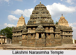
Narasipur: The Lakshmi Narasimha temple here is popular among the pilgrims. The Lord is seen having a balance and kundumani in His hands. The place is as revered and sacred as Kashi.
Biligiri Ranganna Temple: This Vishnu temple of Purana fame is situated amid thick forests on top of the Biligiri Ranga Hills at an altitude of 1566 metres and 120 km from Mysore. Known as Swetachalam, the hill and the various Theerthams are held as sacred as those of Tirumala. Sage Vasishta and his wife had worshipped Lord Vishnu for being blessed with a progeny. They got Shakti as their son, followed by Parasara, Vyasa and Suga as the illustrious lineage.
Sri Rama and sage Parasurama are said to have worshipped Sri Ranganatha. The presiding deity, installed by Vasishta, is worshipped as Srinivasa, Venkateswara and Ranganatha and His consort as Alarmelmanga, Lakshmi and Ranganayaki.
There is a separate shrine for Lord Gangadhareswara. The sculptures of Saraswati, Krishna and Anjaneya on the pillars are worth checking out.
This place can be reached by road via Kollegal, Yelandur or Chamarajnagar.
Mahadeswara Hills: The Shiva temple on top of this hill is dedicated to Sri Mahadeswara. It attracts a lot of pilgrims round the year besides on special occasions like Shiva ratri.
The temples of Gangadhareswara and Lakshminarayana are worth visiting. Rare images of Hamsa Gayatri, Dakshinamurthi and Sri Adi Sankara are worshipped at these religious places.


