 Kalsubai Peak is the highest peak of the Sahyadris in Maharashtra state of India. The height of the peak is 5400ft and is situated exactly in the Ahmednagar district of Maharashtra. Lush greenery, temple of Kalsubai, trekking and various forts in the vicinity are the highlights of Kalsubai Peak. The peak draws explorers and pilgrims throughout the year.
Religious Significance of Kalsubai Peak
At the summit of Kalsubai Peak, there is a small temple of Kalsubai (a local deity), which has a seat for only three people. During the occasion of Navratri, a special fair is organized. The idol is fully adorned and for all nine days, special poojas are carried out. Various stalls are also set up atop the summit from where the devotees can purchase the pooja materials.
Other Attractions of Kalsubai Peak
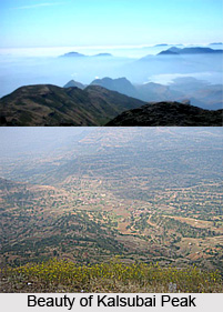
The peak is surrounded by lush greenery and different forts. The north of the Kalsubai Peak displays forts like Ramsej, Harihargad, Brahmagiri, Anjaneri, Ghargad, Tringalwadi, Bahula, and Kavnai. To the east, one can point out Aundha, Vishramgad, Bitangad, to the west Alang, Madangad, Kulang, Ratangad (south west) and to the south Pabhargad, Ghanchakkar, Harishchandragad can also be seen. The vastly spread out backwaters of Bhandardara attracts one`s attention from the top. Also once the monsoon is over, one can enjoy the beauty of clear sky and various charming flowers spread across the mountain.
Trekking at Kalsubai Peak
The peak offers excellent opportunities for trekking and hiking. To reach the summit of Kalsubai Peak there are various trekking routes and animal tracks. The main route starts from the village of Bari, which is about 6 km from Bhandardara. To reach Bari, one has to travel to Igatpuri on the Mumbai Nasik route. From Igatpuri, one can take the early morning bus (at around 5.30 am from the Igatpuri Bus Stand) going towards Pune and alight at Bari.
It usually takes three hours to reach the top from Bari. Soon after leaving Bari, a small stream is crossed followed soon after by a Hanuman temple. The route to Kalsubai Peak from behind this temple takes the hiker straight to the summit. There are three iron ladders along this route. There is a well near the last iron ladder as one move towards the top but the water is not potable during the summer. The rest of the route towards Kalsubai Peak is without water, so the tourists are advised to fill water bottles in Bari. It is an easy hike, but some parts of the route are quite steep in places.


