Introduction
 Ahmednagar District is the largest district in the State of Maharashtra. The district echoes the history of the past. The Ahmednagar fort at Ahmednagar is a place of historical importance. It is at this fort where many of our freedom fighters were detained during the Indian Freedom Movement. It was here that Late Pandit Jawaharlal Nehru was detained during Indian freedom movement and it was at this fort he wrote his famous book "Discovery Of India".
Today, Ahmednagar is a most advanced district having maximum number of large scale and small-scale industries.
Origin of name of Ahmednagar : The name of the District Ahmednagar has come from the name of the founder, Ahmed Shah Nizam Shah.
History of Ahmednagar District
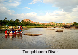 The early history of Ahmednagar starts from 240B.C. when the vicinity is mentioned in the reference to the Mauryan Emperor Ashoka. It was not place of any district importance but small hamlets did lie in the neighbourhood of the present city and were regarded as important by-pass places in between Junner and Paithan. As per history the Andhrabrityas is the name of the dynasty of the ruling kings whose powers lasted from 90 BC to 300 AD and who at the time ruled the Deccan held Ahmednagar in their sway. After that the Rashtrakuta Dynasty ruled over Ahmednagar till about 400 A.D. and the early Chalukya and Western Chalukya kings till 670 A.D. The Rashtrakuta kings again ruled Ahmednagar from 670 to 973 A.D. Govind III (785 to 810) was the mightiest of the Rashtrakutas whose kingdom stretched from Marwar and Rajputana in the north to Tungabhadra River in the south. The caves and temple at Harishchandragad in Akola Tahsil were carved and built during the reign of the Western Chalukyas.
After the Western Chalukyas, Ahmednagar passed on to the Deogiri Yadavs who ruled from 1170 to 1310 AD. Deogiri (modern Daulatabad), seventy-four miles north east of Ahmednagar, was the capital city of Yadavs. The most notable minister and statesman of this time was Hemadri who invented modi script and is still being studied by the intelligentsia. Hemadri was indeed a genius and is credited with lending the idea of constructing buildings without the help of limestone and mortar. Well cut stones of medium size across each other were placed and filled upon each other in particular angles in such a manner that walls were erected in the shape of temple. Twenty six such temples scattered over the whole district that had been built in this style.
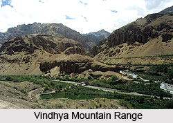 The famous king of Yadav was Ramdeorao. Otherwise strong and brave, the military unpreparedness of the king made face defeat at the hands of Ala-ud-din Khilji, the commander-in-chief of the Mughal king of Delhi at Devgiri in 1294. This was the first ever invasion of the Muslim kings in the South across the Vindhya mountain range. This victory at the very invasion gave a boost to the Muslim ambition of establishing Muslim stronghold in the Deccan. With Ala-ud-din`s death in 1316, Ahmednagar was taken over by his son, Kutbuddin Mubarak Shah. However in 1344, the Hindu rulers of Karnataka and Telangana formed an alliance and put an end to the Muslim rule in the region. The lead was taken by Alladin Hasan Gangu was successful in overthrowing the power of Delhi emperors and establishing an independent sovereign kingdom named after his Brahmin preceptor Gangu Brahmin at Gulbarga in 1347. The kingdom is known as Bahamani or Brahmin kingdom. This kingdom lasted for 150 years ruled by 13 kings after Hasan Gangu Bahamani.
In 1422, it was the turn of Ahmad Shah Wali to attack Ahmednagar. He was the person responsible for building the Bidar Fort. From this time onwards Ahmednagar was slowly approaching to an era when the Nizam Shahi dynasty would be established on its land. By 1490, Malik Ahmad was successful in establishing the Nizam Shahi dynasty in Ahmednagar. The reign continued till 1636. This dynasty was replaced by the Mughal rule in Ahmednagar.
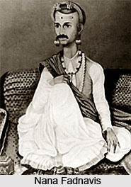
After the death of Nizam-ul-Mulk, there issued a quarrel between his two sons, Salabat Jung and Ghazi-ud-din. In this political mess the Nizam`s commandant Kavi Jung betrayed the fort of Ahmednagar to the Peshwa, the minister of the Maratha power. War followed between the Nizam and the Peshwas in which the Nizam was defeated in 1760 at Udgir. Besides other concessions the Nizam confirmed the grant of Ahmednagar and Dualatbad and also gave up the greater part of the province of Ahmednagar. The Nizam was again defeated by the Maratha in 1795 at Kharda. After the death of Sawai Madhavrao Peshwa in 1795, quarrels arose among the Maratha noblemen. In 1797 Daulatrao Sindia took the fort of Ahmednagar from Bajirao Peshwa, as a price of his help to him to raise him to the post of Peshwa. The famous statesman Nana Fadnavis was imprisoned in Ahmednagar fort in 1797 by Sindia. At last he was released in 1798 but sorely discouraged, Nana Fadnavis died in 1800.
 Bajirao Peshwa was continuously at war with Yeshwantrao Holkar and Daulatrao Sindia. Finally he concluded a treaty with the British for the safety of his Ministership, on 31st December 1802 at Bassein. Lord Wellesley attacked Ahmednagar city and captured it. Then he laid a siege to Ahmednagar fort on 9th of August 1803 and captured it on 12th of August 1803. General Wellesley then returned the fort of the Peshwa soon i.e in 1803. The Holkar also came to terms with the British. There was widespread disorder in the area due to famine and hundreds were looted, murdered and massacred by the Pindaris. There was a rebellion against the British rule by common people headed by Trimbakji Dengale of Sangamner. The British troops soon brought the circumstances under control. At last a treaty was concluded with Bajirao Peshwa at Pune by virtue of which the Ahmednagar Fort was handed over to the English.
When the British Government took possession of Ahmednagar much of it was almost ruined. Many former rich areas were depopulated because of famine and continuous fighting between the British soldiers and the freedom fighters. They continued to rise in arms taking resort to villages and the hills and mountains-mostly Parner, Jamgao and Akola areas. The Kolies and the Bhils harassed the British troops intermittently. Raghoji Bhangria headed this mutiny. At last he was caught at Pandharpur in 1847 and was immediately hanged.
 During the Sepoy Mutiny, 1857 Ahmednagar was in considerable disturbance. The active freedom fighters were about 7000 Bhils under the leadership of Bhagoji Naik. They were active in the hilly tracks and especially in the Parner, Jamgao, Rahuri, Kopargaon and Nasik areas. But at last all these attempts to rise against the British failed and the slavery came to stay.
During the freedom struggle in the 20th century, Bal Gangadhar Tilak organised political movement in the whole of India and was put behind bars by the British Government. But he passed away in 1920 and Mahatma Gandhi took up the leadership and carried on the responsibility of organizing Civil Disobedience Movement. Thousands offered Satyagraha and courted arrest. The famous leader of Ahmednagar, Raosaheb Patwardhan, was underground for many days. Achyutrao Patwardhan was never arrested by the British since he was carrying on the freedom struggle secretively. The veteran leader of Ahmednagar district, Senapti Pandurang Mahadeo Bapat was the most fearless and was one of the greatest disciples of Mahatma Gandhi. He carried on the Mulshi Satyagraha bravely and was arrested in 1937. He was kept behind the bars till India achieved her independence. India attained her freedom on 15th of August 1947 and with this Ahmednagar also achieved its independence. The flag salutation ceremony took place on the ramparts of the Ahmednagar Fort at 8 am on 15th August 1947.
Geography of Ahmednagar District
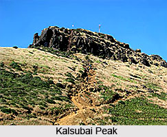 The geography of Ahmednagar District comprises various land forms. There are hilly off-shoots of the Sahyadris in the western part of he district. They are called Kalsubai, Adula, Baleshwar and Harishchandragad hill ranges. Kalsubai, the highest peak in the Sahyadris, lies in Ahmednagar district. Harishchandragad, Ratangad, Kulang and Ajuba are some other peaks in the district. We see the Vita ghat on the way to Randha falls and the Chandanpuri ghat on the Pune-Sangamner road. In the northern part of the district, plains are found along the banks of the rivers Godavari and Pravara and the southern part, along the rivers Bhima, Ghod and Sina.
The different land forms in a region constitute its physical setup. If we consider the physical setup of Ahmednagar district we see that there are three physical divisions:
•* Western Hilly Region
•* Central Plateau Region
•* The region of northern and southern plains
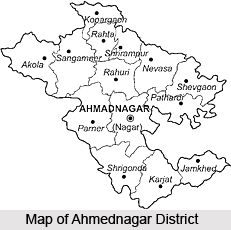
 Western Hilly Region : Akole taluka and of Sangamner taluka are included in this region. The hill ranges of Adula, Baleshwar and Harishchandragad lie in this region and various high peaks are found in the same region. Kalsubai of height of 5427 feet, the highest peak in the Sahyadris, lies in this Region.
Central Plateau Region : Parner and Ahmednagar talukas and parts of Sangamner, Shrigonde and Karjat talukas are included in this region.
Region of Northern and Southern Plains : This region includes northern Kopargaon, Rahata, Shrirampur, Rahuri, Newasa, Shevgaon and Pathardi talukas. This is the region of the Godavari and the Pravara river basins. Parts of the southern talukas of Shrigonda, Karjat, Jamkhed are also included in this physical division. This region covers basins of the Ghod, Bhima and the Sina rivers.
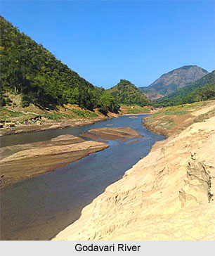
 The district is drained by two chief rivers : Godavari River and the Bhima a tributary of Krishna River. The Water-shed line is the great spur of the Sahyadris which branches off at Harichandragad and stretches completely across the district from west to east. The important rivers flowing through the district are Paravara, Mula, Sina and Dhora. Pravara is tributary of the river Godavari. Water of the river Pravara falls from a great height, creating the Randha Falls.
The Godavari, which drains by far the larger part of the district, including the tahsils of Kopargaon, Sangamner, Akole, Rahuri, Newasa, Shevgaon the northern half of Parner and parts of Nagar and Jamkhed, rises near Trimbak in Nashik on the eastern slope of the Sahyadris. After passing the Nashik city it receives the Banganga and the Kadva from the north and Darna from the south and is already a considerable stream, when, after course of about sixty miles, it enters north-west corner of the Kopargaon tahsil. It then flows south-east through rich alluvial plain past Kopargaon to the town of Puntamba, which is situated on the Nizam`s frontier ,where it receives from the south the combined water of Kat and Khara rivers. From Puntamba to a point beyond Paithan, a distance of sixty miles, the Godavari forms almost continuously the boundary between Ahmednagar and the Nizam`s dominions. At the village to Toka it receives on its right bank the combined waters of the Pravara and the Mula. A few miles below, the Shiva and Ganda join it from the left and the Dhora from the right. Two miles east of Mungi the river enters the Nizam`s dominions, and hence, flowing across the peninsula, it empties itself into the Bay of Bengal after the total course of 900 miles.
The Pravara rises on the eastern slopes of the Sahayadris between Kulang and Ratangad. After the sinuous course of twelve miles in an easterly direction, near the village Ranad, it falls into rocky chasm 200 feet deep and then winds for eight miles through a deep narrow glen which opens wider Valley East of and below the central plateau on which the town of Rajur stands. Total Length of Pravara is 120 miles. The Bhandardara Dam is constructed across the river at Bhandardara, near by are the Randha falls.
The Adhula rises in north of Akole on the Slopes of Patta and Mahakali. It flows for fifteen miles in an easterly direction between two ranges of hills which encloses the Samsherpur valley; then falling into the rocky chasm some 150 feet deep it winds between rugged and precipitous hill-sides for couple of miles, when, debounching in to the plain of Sangamner, it turns south and falls into the Pravara three miles west of the town of Sangamner.
The Mahalungi rises on the southern and eastern slopes of Patta and Aundha. After the course of three miles it passes east into the Sinnar subdivision of Nashik. It re-enters Ahmednagar after taking bend to south.
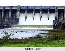
The Mula rises on the eastern slopes of the Sahaydris between Ratangad and Harichandragad. For first twenty miles it flows parallel to Pravara draining the southernmost or Kotul valley of Akole subdivision. Passing the town of Kotul it takes a bend to Baleshvar. It then crosses through Sangamner, Parner. The Mula Dam is constructed across the river at Baragaon Nandur.
The Dhora rises on the slopes of the hills east of the town of Ahmednagar. It flows in the north-east direction, draining Shevgaon and part of Newasa. The Bhima River drains the whole of the southern portion of the district, comprising the greater part of the Parner and Nagar subdivisions, the whole Shrigonda and Karjat, and nearly the whole of Jamkhed.
The Sina River has two chief sources, one near Jamgaon fourteen miles west of the town of Ahmednagar, near, Jeur ten miles to the north-east. The town of Ahmednagar is built on left bank of the river, which there takes south-easterly course. Leaving the district boundary it enters Solapur and ultimately merges with Bhima River.
The western hilly part of Ahmednagar district has forests. Indian Teak tree, babul, dhavada and Neem trees are found in these forests. Fruit trees like Mango, Tamarind, Amla and Bor are also found in the district.
Demographics of Ahmednagar
Ahmednagar had a population of 39,941 as per the 2001 census. Out of which, males constitute 63% of the population and females 37%. The average literacy rate of Ahmednagar is 84%.
Economy of Ahmednagar
There are the presence of many small and large scale industries in Ahmedabad. The small scale industries includes those industries where grains are seperated from their husks, gathering of medicinal plants, bidi rolling, jaggery making etc.
The large-scale industries are engaged in producing `Ayurvedic` medicines. Other large scale industries in Ahmednagar are manufacturing mopeds and T.V. sets. There are pharmaceutical factories, sugar factories and industries for making engines and pump sets. There are spinning mills, ginning and pressing industries too at Ahmednagar.
The large-scale industries are engaged in producing `Ayurvedic` medicines. Other large scale industries in Ahmednagar are manufacturing mopeds and T.V. sets. There are pharmaceutical factories, sugar factories and industries for making engines and pump sets. There are spinning mills, ginning and pressing industries too at Ahmednagar.
Monuments Of Ahmednagar
 The monuments of Ahmednagar are magnificent constructions mainly built by the rulers of the Nizam Shahi dynasty. The town was founded by Ahmad Nizam Shah in 1494 on the site of an earlier settlement. The Nizam Shahi dynasty of Ahmadnagar beautified the city of Ahmednagar by means of a number of architectural works of art, such as forts, palaces, mosques etc. Situated on the flood-plain of the Sina River, the town was Ahmednagar became the centre of a powerful state under the Nizam Shahi dynasty. They went on to build, renovate and fortify the place and subsequently, it was the only state on the west coast of India to maintain control in the face of Portuguese piracy.
A number of monuments are found in Ahmednagar of both historical and religious interest.
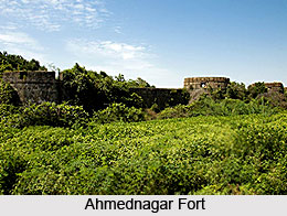
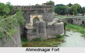
Historical Monuments of Ahmednagar : Chief among the historical monuments are the fort and Farah Baksh palace. To the East of the city at a distance of about 800 miles is the fort built by Husain Nizam Shah in 1559. The main entrance is protected by a powerful circular bastion. In plan the fort is more or less circular in shape and almost 533 ft in circumference. Built of dressed ashlar up to the level of the wall-walk, the outer wall is crenellated with embrasures that are about 60 ft high with a glacis to the outer ditch. Twenty-two circular bastions, including one which is three-lobed, reinforce the defences.
The fort was taken over by Akbar in 1599. Later it was taken from the Nizam by the Marathas. In 1797 the fort was assigned to Daulat Rao Scindia, from whom it was captured by Lord Wellesley on 12 August 1803.
The construction of the Farah Bakhsh Palace was started in 1508, completed in 1574 and rebuilt in 1583.It is mostly in ruins now.
The buildings around the Niamat Khani, which were erected between 1576 and 1578, are also in a similar state.
 Religious Monuments of Ahmednagar
The city has an interesting heritage of Islamic monuments. Many mosques, tombs and dargahs are found here, indicative of an Islamic society.
The town is famous as the residence of the historian Ferishta (1570-1611) and as the last resting-place of Emperor Aurangzeb, who died here on 3 March 1707. Alamgir`s Dargah, a small enclosure near the cantonment, marks his final resting-place before his burial at Aurangabad.
The Qasim Mosque (1500-1508) is one of the best. Small and plainly detailed, it is built of dressed stone with two aisles on either side of the nave. The Husaini Mosque was built by a Persian Shiite who settled here and established a madrasa. The dome of the mosque is spherical and resembles early Persian style, with a broad span carried on a high drum.
The mosque in the Kothla enclosures was constructed in 1536-7 as part of a Shia university under royal patronage. It is a classic example of the flat-roofed technique; built in dressed stone with a heavy eaves cornice over the facade.
The Farhad Khani Mosque built in 1560, has ornamental crestings over the main entrance. A multifoil arch with minarets surrounds the entrance of the courtyard, which has arched chambers and projecting corbelled eaves.
Mecca mosque was built by Rumi Khan, a Turkish officer of artillery under Ahmad Nizam Shah. It was constructed sometime between 1505 and 1525 with trap and limestone masonry. The facade has four unusual polished stone pillars resembling black marble, reputedly brought from Mecca. It may be mentioned here that Rumi Khan is well known for having cast the Malik-i-Maidan cannon at Bijapur.
 During the reign of Uurhan Nizam Shah, flat -roofed structures with taller minarets emerged as a distinct style. The Mosque of Ghulam Ali, near the Gandhi Maidan, is typical of this, with sleek minarets.
The Damadi Mosque, located 800 metres east of the fort, was constructed between 1567 and 1568. It is a small mosque with beautifully carved details and corner piers which carry highly ornamented minarets. The parapet is battlemented with indentures. The carved stonework is superb. Outside the Zenda Gate is the Kari Mosque or Aghi Behizad, with a stilted dome and four high corner minarets.
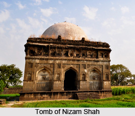
The Tomb of Nizam Shah, one of the finest and best-preserved buildings in the city, is situated in a large enclosure on the left bank of the River Sina. Inside, enough of the original ornamental stucco work survives for the overall effect to be gauged, including geometric designs and texts from the Holy Quran, once highlighted in gold. The tomb is enclosed by a 10 ft wall with four gates on each side. The facade over the main entrance is decorated with beautifully chased stucco work. Adjacent is a canopy alleged to cover the grave of a redoubtable elephant which rendered invaluable assistance at the Battle of Talikota in 1565 AD against the Vijayanagara Raja.
A number of other Islamic tombs can also be seen, including those of Abdur Rahman Chishti and Rumi Khan. The latter has a stilted dome with a band of petals around the base and a trefoil battlement.
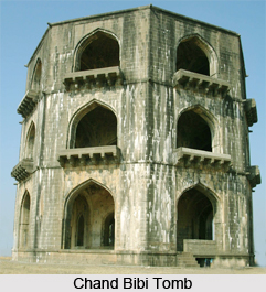
The Tomb of Salabat Khan or the Chand Bibi lies 6 miles east of the city at the summit of a hill. It is an octagonal tomb of three storeys without any inscription.


