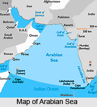
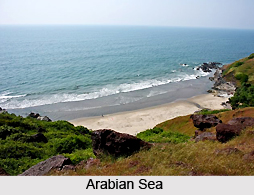
 The Arabian Sea, also known, as Sindhu Sagar is a region of the Indian Ocean bounded on the east by India, on the north by Pakistan and Iran. The west of Arabian Sea is bounded by Arabian Peninsula, on the south, approximately, by a line between Cape Guardafui, the northeast point of Somalia, Socotra, Kanyakumari (Cape Comorin) in India, and the western coast of Sri Lanka. Many times, it is also referred as Arab Sea.
Geography of Arabian Sea
The Arabian Sea, an expansive body of water located between the Arabian Peninsula and the Indian subcontinent, encompasses a vast surface area of approximately 3,862,000 square kilometers (1,491,130 square miles). Characterized by its significant width, spanning about 2,400 kilometers (1,490 miles), and its impressive depth, plunging to 4,652 meters (15,262 feet), this sea holds remarkable geographical importance.
The Arabian Sea branches out into two crucial waterways that greatly contribute to its maritime significance. To the southwest lies the Gulf of Aden, which connects with the Red Sea through the strait of Bab-el-Mandeb, facilitating crucial trade and navigation. In the northwest, the Gulf of Oman extends, forming a vital link with the renowned Persian Gulf. Notably, the Indian Coast hosts the gulfs of Khambhat and Kutch, further adding to the intricate coastal geography of this region.
One of the most influential rivers contributing to the Arabian Sea is the Indus River, flowing into the sea and shaping the surrounding landscape. Its presence has influenced the growth of civilizations along its banks and fostered historical trade connections.
Over millennia, the Arabian Sea has been a hub of marine trade routes, attracting seafarers and merchants since the 3rd or 2nd millennium BCE. The accessibility of this sea has led to the establishment of major seaports along its shores, playing vital roles in international commerce and connectivity. Prominent among these seaports are Kandla Port, Mundra Port, Pipavav Port, Dahej Port, Hazira Port, Mumbai Port, Nhava Sheva Port (Navi Mumbai), Mormugao Port (Goa), New Mangalore Port, and Kochi Port in India, as well as the Port of Karachi, Port Qasim, and the Gwadar Port in Pakistan. Additionally, Chabahar Port in Iran and the Port of Salalah in Oman have further facilitated regional trade and economic activities.
The Arabian Sea is also distinguished by several significant islands that dot its expanse. Notably, Socotra in Yemen, Masirah Island in Oman, Lakshadweep in India, and Astola Island in Pakistan are among the largest and most captivating islands in this maritime domain. These islands harbor unique ecosystems and have played a role in the cultural and historical narratives of the surrounding regions.
As a result of its strategic location, the Arabian Sea`s coastlines are shared by several countries, making it a focal point of geopolitical and economic interests. The nations with coastlines along the Arabian Sea include Yemen, Oman, Pakistan, Iran, India, and the Maldives, each contributing to the region`s diversity and significance.
Other names of Arabian Sea
Throughout history, the Arabian Sea has borne a multitude of names, ascribed by both Arabian and European geographers and intrepid travelers. The diverse appellations bestowed upon this vast body of water include Erythraean Sea, Indian Sea, Oman Sea, Persian Sea, and several others, each reflecting the unique perspectives and cultural contexts of those who navigated its waters.
Among the Arabian geographers, sailors, and nomads, a plethora of designations were employed to refer to this expansive sea. The Akhdar Sea, meaning the Green Sea, found mention alongside Bahre Fars or the Persian Sea, depicting the connections to the rich historical ties with Persia. Furthermore, it was known as the Ocean Sea and the Hindu Sea, underscoring its immense magnitude and its significant proximity to the Indian subcontinent. The Makran Sea and the Sea of Oman were also terms used to delineate specific regions of this maritime domain. These names found their way into the writings of notable scholars and explorers, such as Zakariya al-Qazwini, Al-Masudi, Ibn Hawqal, and Hafiz-i Abru, who remarked upon the enigmatic and diverse creatures that inhabited its depths.
Across the Indian folklore, the Arabian Sea garnered distinct monikers, reflecting the local narratives and cultural heritage. Referred to as Darya, Sindhu Sagar, and Arab Samudra, these names are testaments to the profound impact of the sea on the lives and beliefs of the people dwelling along its coasts.
Notably, the appellation Erythraean Sea has been recorded in ancient texts, including the Periplus of the Erythraean Sea and various ancient maps. In these historical records, the term encompassed the entire expanse of the northwestern Indian Ocean, which included the Arabian Sea.
It is intriguing to note that different regions and communities have continued to bestow diverse names upon this remarkable body of water. In Iran and Turkey, the designation Oman Sea holds sway, highlighting the sea`s connection with the Sultanate of Oman and its influence on neighboring territories.
Trade routes in Arabian Sea
The Arabian Sea has stood as a pivotal artery of maritime trade, facilitating commerce since the days of coastal sailing vessels, a legacy that potentially dates back as early as the 3rd millennium BCE and certainly during the late 2nd millennium BCE, continuing through the Age of Sail.
These ancient trade routes typically initiated in the Far East or along the rivers of Madhya Pradesh, India, with crucial transshipment points at historic Bharuch (Bharakuccha). From there, the journey ventured past the challenging and inhospitable coast of modern-day Iran, before dividing around Hadhramaut, Yemen. The two streams diverged, one to the north, leading into the Gulf of Aden and onwards to the Levant, and the other to the south, connecting to Alexandria through Red Sea ports like Axum. However, the completion of these routes involved intricate steps, necessitating transhipping goods to pack animal caravans, traversing desert terrain fraught with dangers such as bandits and exorbitant tolls imposed by local potentates.
Among these routes, the southern coastal passage cutting through the rugged terrain of the southern Arabian Peninsula held paramount importance. Recognizing its significance, the Egyptian Pharaohs constructed several shallow canals to facilitate trade. One such canal approximately followed the route of today`s Suez Canal, while another linked the Red Sea to the Nile River. Regrettably, these early engineering marvels succumbed to the relentless forces of colossal sandstorms that swept through the region in antiquity.
In later centuries, the rise of the Kingdom of Axum in Ethiopia marked the establishment of a powerful mercantile empire, with its roots firmly embedded in the trade networks connecting Europe via Alexandria.
Major Ports in Arabian Sea
The Arabian Sea boasts a network of major ports, serving as vital gateways for trade and maritime activities in the region. Among these ports, the prominent Jawaharlal Nehru Port in Mumbai stands as the largest in the Arabian Sea and holds the distinction of being India`s premier container port. Alongside this bustling hub, India boasts several other significant ports, including Mundra Port, Kandla Port, Nava Sheva, Kochi Port, Mumbai Port, and Mormugao, each playing a crucial role in facilitating trade and commerce in the region.
The Kochi Port, located on the southwest coast of India, holds particular importance as it stands as the closest Indian port to international shipping routes. Its strategic location, coupled with its size and efficiency, has made it one of the largest and busiest ports in the Arabian Sea, serving as a key link in the global supply chain. The International Container Transshipment Terminal within the port further bolsters its capabilities.
On the Pakistani coast of the Arabian Sea lies the Port of Karachi, the country`s largest and busiest seaport. Positioned between the towns of Kiamari and Saddar, this port plays a central role in Pakistan`s trade and maritime activities, serving as a crucial nodal point for goods in the region.
Further west, the Gwadar Port of Pakistan holds immense significance as a warm-water, deep-sea port. Strategically situated at the apex of the Arabian Sea and the entrance to the Persian Gulf, Gwadar occupies a critical position about 460 kilometers west of Karachi and approximately 75 kilometers east of Pakistan`s border with Iran. Its location on a natural hammerhead-shaped peninsula enhances its potential as a crucial trade and transit hub.
The Arabian Sea also hosts the Port of Salalah in Salalah, Oman, another major port in the area. With the International Task Force often utilizing the port as a base, it serves as a secure and reliable maritime destination. The port`s strategic significance is evidenced by the substantial number of warships from various nations regularly entering and departing from its facilities. Its efficiency and safety contribute to the handling of a substantial volume of cargo, with nearly 3.5 million twenty-foot equivalent units (TEUs) processed in 2009.
 Islands of Arabian Sea
The Arabian Sea boasts a collection of diverse and noteworthy islands, each contributing to the rich tapestry of the region`s geographical and cultural landscape. Among these islands, some of the prominent ones are the Lakshadweep Islands in India, Socotra in Yemen, Masirah in Oman, and Astola Island in Pakistan.
The Lakshadweep Islands, comprising the Laccadive, Minicoy, and Aminidivi Islands, form a captivating archipelago situated in the Laccadive Sea region of the Arabian Sea. Located approximately 200 to 440 kilometers off the southwestern coast of India, these islands are a union territory, governed by the Union Government of India. Despite their relatively small size, with a total surface area of just 32 square kilometers (12 square miles), they hold great importance in the region. Adjacent to the Lakshadweep Islands lie the Maldives islands, and together, they form the Lakshadweep-Maldives-Chagos group of islands.
Notably, the Zalzala Koh Island briefly existed for a few years following the 2013 earthquake in Pakistan. Emerging as a mud island, it was a temporary natural formation that eventually vanished by 2016.
Astola Island, also known as Jezira Haft Talar in Balochi, is a small and uninhabited island situated in the northern tip of the Arabian Sea, within Pakistan`s territorial waters. Referred to as the `Island of the Seven Hills,` Astola Island exudes a unique charm and serves as an intriguing natural wonder.
Socotra, alternatively spelled Soqotra, reigns as the largest island in the Arabian Sea and forms part of a captivating archipelago comprising four islands. Positioned approximately 240 kilometers east of the Horn of Africa and 380 kilometers south of the Arabian Peninsula, Socotra stands as a place of exceptional biodiversity and natural beauty. Adding to the diversity of the Arabian Sea islands are Masirah and the five Khuriya Muriya Islands, nestled off the southeastern coast of Oman. Each of these islands contributes to the region`s rich maritime heritage and ecological significance.
Major Cities of Arabian Sea Coast
The Arabian Sea coastline boasts a multitude of major cities and towns, each contributing to the vibrant tapestry of the region`s economic, cultural, and historical significance. These urban centers serve as vital hubs of trade, commerce, and social interactions, playing pivotal roles in the development and connectivity of the surrounding territories.
Among the noteworthy cities are:
Mumbai: Renowned as the financial capital of India, Mumbai stands as a bustling metropolis and a crucial port city, serving as the largest city along the Arabian Sea coast.
Muscat: Oman`s capital city, Muscat, exudes a unique blend of modernity and tradition, boasting a rich maritime heritage and strategic importance.
Karachi: As Pakistan`s largest and most populous city, Karachi occupies a pivotal role in the country`s economic activities, prominently located along the Arabian Sea coast.
Aden: Positioned on the southern coast of Yemen, Aden is a historically significant port city that has long served as an essential maritime gateway.
Salalah: This Omani city holds prominence as a major port and a key trading center, fostering economic growth and regional connectivity.
Thiruvananthapuram: The capital of the Indian state of Kerala, Thiruvananthapuram, is a cultural hub and a city steeped in history and traditions.
Kochi: Another notable city in Kerala, Kochi, stands as a vibrant port and an important center for trade and tourism.
Kozhikode: This ancient city of Kerala has historical significance as a major trading center dating back centuries.
Kollam: Positioned along the Arabian Sea coast of Kerala, Kollam is a city with a rich maritime heritage and cultural legacy.
Mangalore: Located in Karnataka, India, Mangalore is an essential port city fostering regional trade and industrial activities.
Bhavnagar: This Indian city in Gujarat plays a role in the region`s commercial activities and maritime trade.
Jamnagar: Another significant city in Gujarat, Jamnagar, holds strategic importance due to its coastal location.
Mogadishu: The capital city of Somalia, Mogadishu, has a long history as an important port and center of commerce in the region.
Gwadar: Situated in Pakistan, Gwadar is a key port city that has witnessed significant development and strategic importance in recent years.
Abu Dhabi: As the capital of the United Arab Emirates, Abu Dhabi is a major economic and cultural center along the Arabian Sea coast.
Mundra: This Indian city in Gujarat is known for its large port, fostering trade and industrial activities in the region.
Dubai: Renowned as a global business and tourism hub, Dubai stands as a dynamic city with significant maritime connections.
Kannur: Located in Kerala, India, Kannur boasts historical significance as a key trading port in ancient times.
Panaji: Serving as the capital of the Indian state of Goa, Panaji is a vibrant city known for its coastal charm and tourism.
Karwar: Positioned in Karnataka, India, Karwar is a notable port city fostering economic activities in the region.
Udupi: This coastal city in Karnataka plays a role in trade and cultural exchanges along the Arabian Sea.
Ratnagiri: Known for its historical and cultural heritage, Ratnagiri in Maharashtra, India, has maritime significance.
Murdeshwar: Positioned in Karnataka, India, Murdeshwar is a coastal town renowned for its religious and tourist attractions.
Colombo: The capital city of Sri Lanka, Colombo, holds strategic importance as a major port and trade center.
Takamaka: Located in Seychelles, Takamaka is a picturesque coastal town offering glimpses of the region`s natural beauty.
Dhiffushi: Positioned in the Maldives, Dhiffushi stands as a charming island town with links to the Arabian Sea.
Oxygen minimum zone is Arabian Sea
The Arabian Sea harbors one of the planet`s three largest oceanic oxygen minimum zones (OMZ), commonly known as "dead zones," a phenomenon also observed in the eastern tropical North Pacific and the eastern tropical South Pacific. These zones exhibit exceptionally low levels of oxygen, sometimes reaching undetectable levels using standard equipment. Among these OMZs, the Arabian Sea stands out with the most profoundly depleted oxygen levels in the Gulf of Oman.
Various factors contribute to the formation of the OMZ in the Arabian Sea. Among them, untreated sewage discharge can release excessive nutrients into the waters, promoting the growth of microorganisms that consume oxygen during decomposition. Additionally, high temperatures prevalent on the Indian subcontinent enhance winds blowing towards India, resulting in an upwelling of nutrient-rich waters. While this may enhance productivity and biodiversity, it also leads to the reduction of oxygen levels in the waters.
The Gulf of Oman experiences some of the most extreme conditions within the Arabian Sea`s OMZ, manifesting the lowest oxygen levels in the entire world. During winter, the OMZ undergoes a unique transformation, as specific phytoplankton species adapted to low-oxygen conditions thrive. These organisms exhibit distinctive pigments, causing the OMZ to exhibit a striking bright green hue.
Underwater tunnel in Arabian Sea
A visionary project that aims to construct an underwater rail tunnel beneath the Arabian Sea, connecting the United Arab Emirates (UAE) with the western coast of India is on its way to create a momentous engineering marvel. This ambitious undertaking seeks to bridge the geographical divide between the two nations, fostering enhanced connectivity, trade, and cultural exchanges.
The proposed tunnel, stretching nearly 2000 kilometers in length is supported by advanced pontoons and designed with meticulous precision. This monumental project embodies the spirit of innovation and progress, transcending physical boundaries to create a path of connectivity and unity beneath the depths of the Arabian Sea.
Arabian Sea
Arabian Sea is a region of the Indian Ocean surrounded on the east by India, on the north by Pakistan and Iran.


