 Deccan Rivers are the peninsular rivers of India. Peninsular rivers contribute 30 percent of the total outflow in India. The Indian River System is divided into two basic sections, with relative differences in several spheres of irrigation. They are the rivers of northern India and the rivers of southern India. The southern section of India is predominated by the Deccan Plateau, the Western Ghats Mountain Range, the Eastern Ghats Mountain Range, the Vindhya Mountain Range and the Satpura Mountain Range. Thoroughly dissimilar from their illustrious northern counterpart, the Himalayan Mountain Range, mountains and hills in the southern and western section of India have several rivers important to India in almost every walk of life. In order to grasp and assimilate Deccan Rivers and their final path into the sea and ocean, it is necessary to first understand the Deccan Plateau and its features.
Deccan Plateau Region of India and its Features
The Deccan Plateau region of India is a part of peninsular India. Peninsular India has vast plateau regions of western India and southern India. It receives rainfall in varying amounts throughout the year. There exist certain areas receiving scanty rainfall and areas witnessing excessive rains. Climate in the west vastly differ from its southern counterpart. Western India has immensely scanty vegetation, which is exactly the opposite in the south. As such, these crucial factors are bound to leave an everlasting impact upon flow of water bodies, precisely rivers. The Deccan Rivers are overwhelming in their course at times and run dry for most of the year at other times.
 Major Deccan Rivers
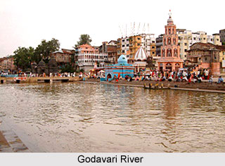
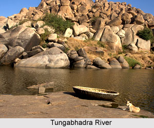
The major nation feeding Deccan Rivers are the Godavari River, Krishna River, Cauvery River (popularly known as Kaveri River), Mahanadi River, Narmada River, Tapti River, Indravati River, Tungabhadra River and Bhima River. Godavari River, Krishna River and Kaveri River wind their paths in the Bay of Bengal. Narmada River and Tapti River are the major west flowing rivers moving towards the Arabian Sea.
Other Deccan Rivers
Other Deccan Rivers are Pennar River, Damodar River, Sharavati River, Netravati River, Bharathapuzha River, Periyar River and Pamba River.
Features and Utility of Deccan Rivers
Deccan Rivers are primarily rain-fed and thus, immensely fluctuate in volume. Most of them are additionally non-perennial in nature. A large number of them being primarily seasonal and dependent upon rainfall create troubles for the local populace from the adjacent lands. The hard rock bed and almost absence of silt and sand does not allow any significant rambling or meandering in the course of the rivers. Many rivers thus outline linear courses. Deccan Rivers run remarkably through shallow valley sections. Erosion is relatively low due to gentler slope. Deccan Rivers provide huge possibilities to harness hydro-electric power.


