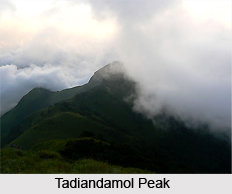
 Tadiandamol Peak is the highest mountain in the Kodagu district of Karnataka. It is the second highest peak in Karnataka. It is one of the beautiful peaks in the state. The clouds and mist surrounding the peak in the early morning is a treat to the eyes. Tadiandamol peak is quite popular among the mountaineers, trekkers, photographers and nature lovers.
Etymology of Tadiandamol
The literal meaning of Tadiandamol is `highest point`. The name also could translate as "broad hill", "largest base", and "tallest mount".
Location of Tadiandamol Peak
It is located on the Western Ghats range. Tadiandamol is situated at a height of 5,250 feet above mean sea level. The peak reaches an elevation of 1,748 m.
Attractions of Tadiandamol Peak
Tadiandamol is enveloped with beautiful and serene surrounding. The mountain has shoal forests in the valleys. It also houses beautiful lush green grasslands and streams. The peak is located near the Makutta Forest and is noted for its coffee plantations. On the way to Bhagamandala, Tadiandamol is at a distance of forty kilometres from Madikeri and about thirty- five kilometres from Virajpet. One can also visit Padi Igguthappa temple which is just a few kilometres away from Tadiandamol peak. This temple is one of the holiest temples for the Kodavas. Nalkunadu Palace and Abbey Waterfalls are the other places of attraction in the vicinity.
Trekking at Tadiandamol Peak
The ideal time to trek this peak is early winter. The peak throws exciting challenge to the people however; trekkers never shy away from the challenges. According to many climbers, the trek is not too strenuous but one can expect leeches in the monsoon and post-monsoon seasons.
The starting point of trek is Near Kakkabe. Tadiandamol is 8 km from the town of Kakkabe. One can rest at Nalaknad Palace before climbing the Tadiyandamol peak in the morning. A narrow path from the Palace takes to the Tadiandamol peak.
Connectivity of Tadiandamol Peak
Tadiandamol is well connected with the Indian states of Kerala and Karnataka. The nearest airport is Bangalore which is 321 km from Tadiandamol. The closest railhead is also Bangalore and is 263 km from Tadiandamol. One can avail taxi service from Bangalore to reach Tadiandamol.


