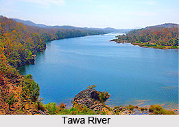
 The Tawa River flowing through central India is the longest tributary of the Narmada River. The river is 172 km in length. It originates in the Satpura Range of the Betul and Chhindwara districts of Madhya Pradesh. The river then flows in the north and west direction where it enters the village of Bandra Bhan in Hoshangabad district. Bandra Bhan is the meeting point of Narmada and Tawa River and there lies an eminent sand sculpture by world renowned sand artist Padma Shri Sudarshan Pattnaik.
Tawa Dam
In the year 1978 the Tawa Dam was constructed across the river. It is situated at the confluence of Tawa and Denwa rivers. 44 villages were submerged by the reservoir. Tawa Reservoir is a large reservoir on the Tawa River in central India. The reservoir is almost 57.91 m high and 1,815 m long.
The dam provides water for irrigation to several thousand hectares of farming land in Hoshangabad and Harda districts. It is also a big tourist attraction during the monsoon months. A Cruise boat service has been started by the tourism department for visitors to the dam and reservoir. The dam has brought prosperity to the Hoshangabad district.
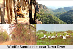 Nearby Attractions of Tawa River
•The Bori Reserve Forest was established along the Tawa in 1865. Tawa Reservoir is nestled between the western boundary of Satpura National Park and Bori Wildlife Sanctuary. The Bori-Satpura Tiger Reserve is an ideal destination for anyone who is a keen wildlife enthusiast. The Bori-Satpura Tiger Reserve lies in the Mahadeo Hills of the Satpura Range. The fascinating deep valleys, narrow gorges, cascading waterfalls and rich vegetation of the Bori-Satpura Tiger Reserve represent nature at its very best.
•The Pachmarhi Biosphere Reserve is a non-use conservation area and biosphere reserve in the Satpura Range of Madhya Pradesh state, in central India. The conservation area was created in 1999 by the Indian government.
•Pachmarhi is a hill station of Madhya Pradesh situated on a large plateau Mahadeo hills of Satpura ranges. It is widely known as "Queen of Satpura". Pachmarhi Hill Station is situated at the height of 3555 ft from sea level. Pachmarhi has all characteristics of scenic beauty of Nature. Waterfalls, streams, wild-life and presence of some rare species of medicinal plants have made it most picturesque tourist spot of Madhya Pradesh.
•Since, Hoshangabad is the nearby district; the Sethani Ghat is an important landmark of Hoshangabad which is also visited by the tourists. It is tiled with stones and one of the most beautiful Ghats found in central India. It is also one of the biggest ghats on the river Narmada.


