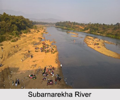
 Also known as Swarnarekha, the Subarnarekha River is the smallest of India"s main interstate river basins. The Subarnarekha River has reddish blue water and flows through the states of Jharkhand, West Bengal and Odisha.
Multipurpose projects executed on Subarnarekha River relate to the construction of Chandil Dam, Icha Dam and Galudih Barrage. These structures on the river are useful to the farmers of the three eastern Indian states.
Etymology of Subarnarekha River
The name Subarnarekha is a combination of 2 languages, Sanskrit and Bengali. The words "Subarna" stands for gold and "Rekha" stands for a line or streak. Thus, Subarnarekha means a "streak of gold" in English. According to traditional stories, it is believed that gold was once mined near the origin of the Subarnarekha River and was even found on the river bed. Thus, the river received the name of Subarnarekha.
Course of Subarnarekha River
Subarnarekha River originates near a village namely, Piska or Nagri close to Ranchi. With a drainage area of about 1.93 million hectares, the Subarnarekha River traverses for a long distance through the districts of Ranchi, Seraikela Kharsawan and East Singhbhum. It then covers short distances through Paschim Medinipur district in West Bengal and Balasore district in Odisha. Subarnarekha River finally joins the Bay of Bengal, near Talsari.
Tributaries of Subarnarekha River
The major tributaries of Subarnarekha River are Kharkai River, Roro River, Kanchi River, Harmu Nadi, Damra River, Karru River, Chinguru River, Karakari River, Gurma River, Garra River, Singaduba River, Kodia River, Dulunga River and Khaijori River.
Places of Interest near Subarnarekha River
There are various places of interest near Subarnarekha River, like the Chandil Dam, which is one of the most visited places in the area. The museum located close to the Chandil dam has scripts written on rocks, which are 2,000 years old. Another of the popular places of interest near the river is the Hundru Falls, which is located at a distance of about 45 km from Ranchi and falls from a height of about 98 m. There is also a temple dedicated to Lord Shiva called the Bhavnatha Mahadev Temple, situated on the banks of Subarnarekha River that attracts devotees from all over. Other than these, located close to the Subarnarekha River is a hill station in the Chota Nagpur Plateau region of Jharkhand that is a popular tourist location.
Pollution in Subarnarekha River and its Effect
Subarnarekha River crosses areas where extensive mining of copper and uranium ores takes place. Thus, the river gets polluted due to the unplanned mining activities. Subarnarekha River is the lifeline of the tribal communities inhabiting in the Chhota Nagpur region of India. The lives of the tribal people are adversely affected by water pollution.


