Introduction
Balasore District, an administrative district of Odisha and it is considered as the Granary of Odisha. Balasore is the launch station for sounding rockets in Odisha state.
Location of Balasore District
Balasore District is one of the coastal districts of Odisha lying on the northern most part of the state having 21 degree 3 minutes to 21 degree 59 minutes north latitude and 86 degree 20 minutes to 87 degree 29 minutes east longitude. It is bounded by Midnapore district of West Bengal in its north, by the Bay of Bengal on the east and Bhadrak district lies on its south whereas it is surrounded by Mayurbhanj District and Kendujhar district on its western side.
History of Balasore District
The history of Balasore is the amalgamation of several cultures and civilizations colonized the region for a couple of years. However Balasore was a part of the ancient Kalinga, which later came under the jurisdiction of Toshala or Utkal till the death of Mukunda Deva. The history of Balasore witnessed a quick succession of several dynasties in its bosom. When the power of the indigenous Hindu kings falls short to retain their kingdom with a strong foundation, the Mughals emerged and annexed it in 1568. The Marahattas overpowered Mughals and the realm of Balasore was passed into the hands of the Marhatta Rajas of Nagpur. As far as the history of Balasore is concerned, there was a constant strife among the different rulers over the entire tract of Balasore. Finally during the British expedition in India, the absolute political power came in the hands of the British Raj.
The present history of Balasore is recorded from the commencement of the British imperialism in India along with the entire region of Orissa. Balasore was the important site of the British administration in Eastern India. The east India Company ceded this part of Balasore to the British Government in England by a treaty called treaty of Deogaon, which was the beginning of the British era in the history of Balasore. But as the documented history of Balasore depicts, the English settlement in Balasore began during the reign of the Muhgal Emperor Shah Jahan far back in 1634. However the British arrive at that time with the design to establish their trade in the profitable region of India. They settled in Balasore because of the positional significance of Balasore.
The first English factories were established in Balasore in 1640. During this time the Dutch and Danish settlements were also found established their bases in Balasore. Balasore as a separate district was recognized as the separate district in year 1828 when it was a part of the Bengal Presidency. But with the creation of the State of Orissa as a separate functional unit, on 1st April 1936, Balasore was annexed with Orissa. After independence the whole of Orissa has underwent several changes owing to the alteration in its boundaries.
The state of Nilagiri merged with state of Odishain January, 1948 and became a part of Balasore district. On 3rd of April, 1993 Bhadrak Sub-division became a separate district. The historical legend ascribes that the district has been named as per Lord Baneshwar, which subsequently changed to Balasore during Mughal Rules.
Geography of Balasore District
Balasore District can be divided into three geographical regions, namely, the Coastal belt, the inner alluvial plain and the North-Western hills. The coastal belt is about 26 kilometres wide and shapes like a strip. In this region, sand dunes are noticed along the coast with some ridges. This region is mostly flooded with brackish water of estuarine rivers which is unsuitable for cultivation. The second adjacent geographical region is deltaic alluvial plain. It is a wide stretch of highly fertile and irrigated land. This area is highly populous and devoid of any forests. The third region is mostly hilly terrain and vegetated with tropical semi-ever green forest.
Balasore, the coastal district of Odishais crisscrossed with perennial and estuarine rivers because of its proximity to sea. The irrigation system in Balasore district is quite extensive. Industrialization is also gaining ground around Balasore town. The soil of Balasore district is mostly alluvial laterite. The soil of Central region is mostly clay, clay loam and sandy loam which is very fertile for paddy and other farm produces. Moreover, a small strip of saline soil is also seen along the extreme coastal part of the district.
Climate of Balasore District
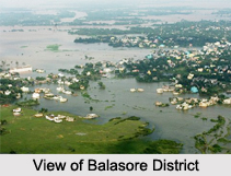
The climate of Balasore District is mostly hot and humid. The hot season starts from March till May and followed by rainy season from June to September. During this period, south-west monsoon causes maximum rain. But the district experiences highest rain fall during July and August. Because of its strategic location, this district faces most of the cyclonic storm and depression which is raised from Bay of Bengal. The cold season from December to February is very pleasant. The average temperature of the district varies between 22 degree Celsius to 32 degree Celsius and the average rain fall is 1583 mm.
Demography of Balasore District
The total population of Balasore District is 20,23,000 comprising 10,38,000 males and 9,85,000 females. The average literacy rate of the city is 76 percent, higher than the national average of 59.5 percent. Male literacy rate of the district is 56 percent and female literacy rate is 44 percent.
Economy of Balasore District
Balasore is one of the economically developed districts in Orissa, which is privileged in both agriculture and industry. In spite of being an agrarian economy, agriculture is the main stay of the people of Balasore. Agriculture contributes upto 51% of Orissa`s total domestic income. Balasore in the coastal section of Orissa is blessed with hot and humid climate with alluvium soil and intersected by the perennial rivers, which collectively provides conducive infrastructure for the growth of agriculture in this region.
The coastal region is mainly drained by the brackish water of the estuarine rivers, which does not support the production of food crops. Formerly this region was unutilized. In the recent years, the utilization of the wasteland for ensuring the economic development of Balasore has been taken into consideration and it is being used for the production of coconut and betel. The land reforms programs have already been planned for the maximum usage of wasteland and the hybrid varieties of seeds to ensure the productivity of the crops, thereby enhancing the economic stability of Balasore.
Since the network of the perennial rivers drains Balasore, irrigation facility is well organized. Among the three sub divisions of Balasore, the contiguous alluvium plain is the site of food crop cultivation. The local economy of Balasore largely depends on the cultivation of paddy and wheat.
Though a major section of Orissa`s population depends on agriculture, industry is the nucleus of the economic development of Balasore. In the financial years, government has planned for the promotion of large and medium scale industries including the small handicraft and cottage industries. The undivided Balasore District was tagged as a "no industry district". With the establishment of D.I.C (District Industrial Center), functioning from the year 1978, Balasore has witnessed prominent success in the field of industrial development.
D.I.C provides the single window facilities to the entrepreneurs interested for setting up small-scale industry unit (SSI) in Balasore. Moreover it provides inputs like finance, IDCO / Govt. land and Shed, scarce raw- materials, power as well as marketing assistance through various related organizations, thereby ensuring economic development of Balasore.
Apart from the government undertakings and the public sectors, a group of private entrepreneurs have come up, which accentuated the industrial development prominent in the economic scenario of Balasore. These industries in the recent times not only provide employment to the local populace but at the same time accounts for a quantum of exports, which supports the economy of Balasore greatly.
Balasore, in recent years has attained prominence in the international scenario for the exceptional progress it has made in the field of industry.
Administration of Balasore District
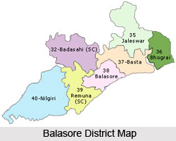
The two sub divisions of Balasore District are Balasore and Nilagiri having 19 Police Stations, seven Tehsils for revenue and administrative purposes. Only Nilagiri sub division is of hilly region with hillocks and forests. For undertaking developmental works in the rural areas, the district is also divided into 12 Development Blocks namely Bhograi, Jaleswar, Baliapal, Basta, Balasore, Remuna, Nilagiri, Oupada, Khaira, Soro and Bahanaga. Besides, there are four statutory towns consisting of one municipality under the administration of Balasore District. These local bodies look into civic aspects of urban areas.
Tourism in Balasore District
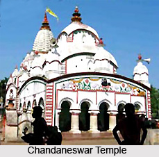
Balasore District is a place of scenic beauty and is one of the major tourist attractions of the state. The stretches of green lands, network of rivers, blue hills and extensive meadows adds to the natural beauty of the place. The place is a major tourist attraction because of the presence of many temples in this area. Some of the main places of attraction in Balasore District are Remuna, Chandaneswar Temple, Panchalingeswar, Sajanagar, Ayodhya, Maninageswar Temple at Bardhanpur and many more. Here are a few popular tourist spots in Balasore district of Odisha.
Chandipur: The peaceful tranquil beach of Chandipur is considered as one of the fine beaches of the country. The water of the sea here recedes 5 km of shore and proceeds after a rhythmic and regular interval after a short while. The green sand dunes with the continuous play of the tides and the whistling casuarinas invest the place with enormous interest for the tourists.
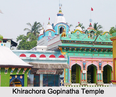
Khirchora Gopinath Temple: Apart from being an important seat of religious interest, Khirchora Gopinath Temple at Remuna is equally important for the historical significance associated with it. The temple has been a seat of the Vaishnawite Culture for centuries. The historical importance of the place lies in the fact that Madhavendra Puri, guru of Isvara Puri whose disciple was Shree Chaitanya Mahaprabhu, himself visited the place to worship Khirchora Gopinath. About hundreds of devotees gather here daily to have a sacred Darshan of the god. A mass of pilgrims concentrate here everyday constitutes the vast chunk of tourists of Khirchora Gopinath Temple at Remuna.
Sajnagarh: The primary attraction of Sajnagarh is the legendary shrine of Goddess Bhudarchandi. The boundary walls of the temple are fabricated with the exquisite stone works.
Ayodhya: Ayodhya represents the idea of "Unity in Diversity" in the assimilation of Shaivism, Shaktism Jainism, Budhism, Baishnavism and Tantrism in its core.
Talasri: Charka Mela is the key attraction of Talasri. Everyday near about thousand of devotees flock together to offer their worship and have a "darshan" of Lord Chandaneswar.Throughout the year, tourist folk concentrate in the city of Talasri.
Visiting Information
Balasore District is connected with all the major rail heads of Eastern Ghats Mountain Range in India. The South Eastern Railway covers a distance of around 102 kms within Balasore District connecting it with Kolkata, Bhubaneswar and Chennai. Moreover, National highways 5 and 60 pass through the district and runs from Kolkata to Chennai.