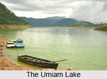
 Umiam Lake is located in the state of Meghalaya, India. More specifically, it is situated in the hills, about 15 km to the North of Shillong. It is also famously known as the Barapani or Big Water. Characteristically, it is a man made or artificial lake and a reservoir created by damming the river Umiam. The construction of the dam started in 1965. This lake is also recognized as the first hydel power project in the North-east region of India.
Geography and Hydrography of the Umiam Lake
The principal catchment area of the Umiam Lake and the dam is spread over about 220 square km, which includes Shillong and its adjoining areas, besides a portion of Ri Bhoi district. This lake is graced by the surrounding coniferous forests. The confluence of the two streams Umkhrah and Umshvrpi form the Wah Ro-Ro stream in the north-west of Shillong and joins River Umiam, which drains its water in this lake.
Ecological and Economic Values of the Umiam Lake
The Umiam Lake provides a large number of ecosystem services at micro, meso and macro levels. It is responsible for power generation in Meghalaya. It also supports downstream irrigation, fisheries and provides drinking water (rangmen cantonment area). Meghalaya has recognized the potential of the Umiam Lake for tourism and turned it into a tourism product. The lake has been developed by the Meghalaya Tourism Department in spite of the fact that the management of the lake lies completely with the Meghalaya State Electricity Board. As a tourist spot, this lake allows kayaking, water cycling, scooting and boating.
Ecological Crisis Faced by the Umiam Lake
Rapid increase in the population of Shillong has resulted in the pollution of the Umiam Lake. It has turned into a dumpsite, with urban waste being released into this lake, without any prohibition. Research conducted by the Central Pollution Control Board (CPCB) found that the water in the rivers Umkrah and Umshyrpi has significantly high levels of sewage. Such polluted river systems feed the Umiam and has changed its biological nature. The CPCB has thus declared this lake as polluted, which has consequently rendered its water toxic for any domestic use except irrigation, without conventional primary treatment. Also, increasing levels of silt in the streams and rivers is resulting in high levels of silt in the Umiam. An estimated 40,000 cubic metres of silt enter Umiam Lake every year. Upstream encroachments, deforestation, blockage of natural drainage systems and unscientific mining in the catchment area, are some of the reasons deteriorating the quality of this lake. The excessive silt burden carried by this lake has lowered its storage capacity.
Belief Regarding the Formation of Umiam Lake
The Umiam literally translates into "water of tears". It is believed that two sisters wanted to descend from heaven. Unfortunately, one of the sisters got lost in the way. The other sister was thus extremely saddened by this loss. On reaching Meghalaya, she started crying excessively. It is believed that these tears of grief formed the Umiam Lake.
Related Articles:
Lakes of India
Water Resources in India
Meghalaya, Indian State
Districts of Meghalaya
Tourism In Meghalaya
East Garo Hills District, Meghalaya
Geography of Meghalaya