
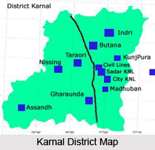
 Karnal District is one of historical districts of Haryana. It is also known as `Daanveer Karn`. Karnal city is the district headquarters. Karnal District is known all over the world for production of rice, wheat and milk. It is also known for agriculture research Institutions like NDRI, CSSRI, Wheat Research Directorate, National Bureau of Animal Genetics Resources, Sugarcane Breeding Institute etc. Karnal District was also a district in erstwhile Punjab.
Karnal District
Karnal District is one of the oldest districts of Haryana, since the inception of the state on 1st of November, 1966. Kurukshetra, Kaithal and Panipat were parts of Karnal District before getting the status of separate individual districts.
Introduction
Karnal District is one of historical districts of Haryana. It is also known as `Daanveer Karn`. Karnal city is the district headquarters. Karnal District is known all over the world for production of rice, wheat and milk. It is also known for agriculture research Institutions like NDRI, CSSRI, Wheat Research Directorate, National Bureau of Animal Genetics Resources, Sugarcane Breeding Institute etc. Karnal District was also a district in erstwhile Punjab.Location of Karnal District
Karnal District lies on the western Bank of Yamuna River which traverses about 11 kms to the east, forming the eastern boundary of the district. River Yamuna separates Haryana from Uttar Pradesh. Karnal District including Panipat lies between 29 degree 9 minutes 50 seconds and 29 degree 50 minutes north latitude and 76 degree 31 minutes 15 seconds and 77 degree 12 minutes 45 seconds east longitude. Average altitude of Karnal District from sea level is between 235 and 252 meters. Karnal District is surrounded by Kurukshetra District on its north-west, by Jind District and Kaithal District on its west, by Panipat District on its south and by Uttar Pradesh on its east.
History of Karnal District
 History of Karnal District, which is located in Punjab, speaks about the political scene of this area since the time when it was ruled by some royal dynasties. Raja Karna, who finds a mention in the Hindu epic of Mahabharata is believed to have been the founder of Karnal and the district came into existence in the year 1739. The district was formed when Muhammad Shah was defeated by Nadir Shah. During 1863, Raja Gopal Singh of Jind captured Karnal and in 1785 the Marhattas started controlling the area of Karnal. Karnal witnessed political conflicts between the Sikhs and Marhattas. The word `Karnal` has been derived from `Karnalaya` which implies the home of Karna, a character in Mahabharata.
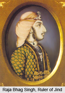
Karnal was eventually conquered by the Marhattas from Raja Bhag Singh of Jind in the year 1795. George Thomas also participated in this war. At this point of time, Karnal was seized by Raja Gurdit Singh of the region of Ladwa. The British captured Karnal during 1805 and transferred the throne of Karnal to Muhamdi Khan (Mandal). The British then took possession of the fort which had been constructed by Raja Gurdit Singh as it had become a British cantonment. This fort was made into a beautiful residence for Kabul`s Dost Mohammad Khan Amir. Historians state that the fort was utilized a prison house, a house for the poor and even as a quarter for native cavalry. In the year 1862, the fort was granted to the Education Department, when the district school was shifted here.
On 1st November, 1966, Karnal district was declared as one of the seven districts of the northern Indian state of Haryana. It was during this time that the inception of this Indian district took place. The district of Kurukshetra was separated from Karnal district on 23rd January, 1973. On 1st November, 1969, Kaithal district was separated from Karnal. During 24th July, 1991 Karnal district was joint with Panipat District on 1st January, 1992.
Geography of Karnal District
Yamuna River forms the eastern boundary of Karnal District and flows from north to south. The district is a part of Indo Gangetic plain and has a well spread net work of western Yamuna canal. Its geographical area has been divided into three agro climatic regions, Khadar, Bhangar and Nardak belt. Khadar starts from Indri-Karnal road one mile away from Karnal covering the area in between Yamuna River and National Highway number 1 up to Patti-Kalyana village. Bhangar area starts from west of Khadar area covering Gharaunda development block. The nardak area lies in Nissing, Nilokheri and Assandh development block. However, its water is saline and not fit for irrigation.
Administration of Karnal District
Deputy Commissioner runs the district administration, and is responsible for maintenance of law and order and redresses the grievances of the public and implements all the policy decisions of the government. Karnal District is divided into two Sub Divisions, five tehsils and three sub tehsils. It has 435 villages. The total population of Karnal District as per 2001 Census is 12,74,843.
Tourism in Karnal District
 Tourism in Karnal District offers visits to several places of religious and historical interest. Karnal District offers all the scope for having an enriching tourism experience. The tourist spots of this district of Haryana attract travellers from far and wide. Cantonment Church Tower, Dargah Nuri, Miran Sahib`s Tomb, Kalander Shah`s Tomb and Sita Mai Temple are some of the main attractions of this district. Their details are mentioned below.
Pilgrimage Tourism in Karnal District -
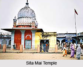
Sita Mai Temple: Situated at a distance of 19 kms from Nilokheri, is a small village known as Sitamai. There is an old shrine of Sita. Sita Mai Temple is made in a simple style, but the main feature is the elaborate ornamentation which covers the whole shrine, the pattern of which is formed by deep lines in the individual bricks which seems to have been made before the bricks were burnt. The shrine is said to mark the spot where earth swallowed Goddess Sita in answer to her appeal in proof of her purity.
Gurudwara Manji Sahib and Devi Temple are other noted pilgrimage tourism of Karnal District. Apart from these tourist spots, the other places of interest include Kunjpura, Basthali, Gondar and Shamgarh. These are some of the popular ancient places of Karnal District. All these sites are worth visiting.
Leisure Tourism in Karnal District -
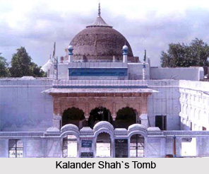
Kalander Shah`s Tomb: Kalander Shah`s tomb is situated outside Karnal city. The grave is made of marble and decorated with sculpture. The tomb was built by Ghiyas-ud-din Tughlaq, Emperor of Delhi, who influenced the thinking of his age and was very widely revered by all communities. Within the enclosure are mosque and a reservoir with fountains built by Emperor Alamgir.
Cantonment Church Tower: This is a big old massive tower and can be seen from a distance of several miles as it is 100 feet in height. The church was dismantled with the shifting of the Cantonment to Ambala in 1841 AD.
Old Fort: Constructed by Raja Gajpat Singh of Jind in around 1764 AD, it is an attractive tourist site of Karnal.
Miran Sahib`s Tomb: This tomb stands in the memory of a saint, Syed Mohammad, who died in 899 AD. The tomb is situated at the extreme south of the town.
Dargah Nuri: There is a Dargah Nuri at village Newal. This Dargah was built in the memory of Hazrat Sufi Shah Alama Nur Mohammad of Delhi, and is managed by a Managing Committee, village Newal.
Karna Tank: Karna Tank, named after Karna is now being renovated and converted into a tourist spot by Karnal municipality. It is said that Raja Karna, who was very philanthropic used to give gold to the needy at the spot.
Naraina: This village is of historic interest and is located eleven miles north of Karnal. Aurangzeb constructed a wall around the town, a mosque and a tank which still exists.
Recently updated articles in States of India

Bandare Waterfalls, Meghalaya
Bandare Waterfalls in South Garo Hills, Meghalaya, is a secluded natural attraction surrounded by dense subtropical forests and rugged mountain terrai...

History of Thissur District
Early History of Thissur District explains flourishing of the port cities. Now these port cities are transformed into archaeological sites.

Tippi Orchid Research Centre, Arunachal Pradesh
Tippi Orchid Research Centre in Arunachal Pradesh is renowned for its rich collection of exotic and endangered orchids. Surrounded by lush rainforest...

Tourism in Nashik District
Pilgrimage tourism in Nashik district involves visiting the various places of Hindu and Jain worship located here. Some of the holiest sites for Hind...

Mangadu, Kerala
Mangadu in Kerala’s Kollam district is a significant megalithic site known for its urn burials, cist burials, menhirs, and stone circles. Excavations...
Related articles in States of India

East Indian States
East Indian States comprises of Bihar, Jharkhand, West Bengal, Odisha and also the Union Territory of Andaman and Nicobar Islands. It defines the cult...

Purnia District in Bihar
Purnia District is located in Bihar and extends from River Ganga to Nepal. The district has a rich Hindu history and glorious past.

Hooghly district
Hooghly District along the bank of the river Hooghly is one of the principal trading ports of West Bengal.

Geography Of Chittoor District
Geography of Chittoor district is spread along the topography of the land which is divided into two natural divisions; Chittoor has a dry and healthy...

Districts of West Bihar
Districts of West Bihar is comprised of medieval monuments that were built by the different governors of Mughal era.