 Arabian Sea is located north of Indian Ocean. It has a surface area of about 3,862,000 square kilometers, maximum width of about 2,400 km and maximum depth of about 4,652 m. This water body contributes to the economy of India by serving as a marine trade route and housing major ports. Arabian Sea also has islands, many of which act as tourism products of India.
Coral Islands of India in the Arabian Sea
Aminidivi Islands, Laccadive Islands and Minicoy Island are together named Coral Islands of India in the Arabian Sea. More specifically, they form the three island subgroups of the Union Territory of Lakshadweep in the Arabian Sea.
Aminidivi Islands
Aminidivi Islands occupy an area of about 9.26 square kilometers (3.58 sq mi). The geographical terrain of Aminidivi is characterized by reefs, banks and atolls. Cherbaniani Reef, Byramgore Reef and Perumal Par are the reefs of Aminidivi Islands. Banks of this group of islands are Cora Divh, Sesostris Bank, Elikalpeni Bank and Bassas de Pedro. Its atolls are Chetlat Island, Bitra Island, Kiltan Island, Kadmat Island and Amini Island.
Laccadive Islands
Laccadive Islands occupy an area of about 17.5 square kilometers (6.8 sq mi). The geographical terrain of Laccadive is characterized by atolls and islet. Atolls of Laccadive Islands are Agatti Island, Bangaram Island, Androth Island, Kavaratti Island, Kalpeni Island and Suheli Par. Pitti Island is regarded as the islet of Laccadive Islands.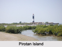
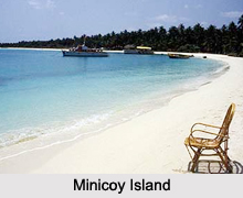
Minicoy Island
Minicoy Island is regarded as the second largest and the southernmost among the islands of the Lakshadweep archipelago. It occupies an area of 4.801 5 square kilometers and has tropical savanna type of climate. This island has 10 villages which are called Athiris. The noteworthy aspects of this island are a lighthouse, an inland lake, lava dance, a tuna canning factory and coconut trees.
Basavaraja Durga Island
Basavaraja Durga Island in the Arabian Sea is a part of the Indian state named Karnataka. This island occupies 19 hectares of land and has an elevation of about 45 to 50m. The geographical terrain of this island includes a plateau covered with dry grass and trees which will be evident only at the sloping part of the island. This island is adorned with Basavaraj Durga Fort, a Hindu temple and fresh water wells.
Pirotan
Pirotan Island is an Arabian Sea island in Jamnagar district. It occupies an area of about 3 square kilometers. Public entry is permitted on this island. This island comprises of mangroves and low-tide beaches. The mangroves consist mainly of species like Rhizophora, Avicennia and Ceriops. The sacred shrine of Khwaja Khijer Rahmatullahialaih is situated on the island.
Islands of Arabian Sea
Many Islands of Arabian Sea act as tourism products of India.


