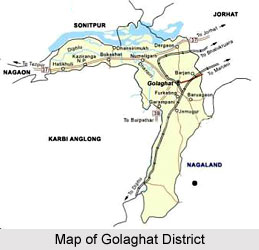
History of Golaghat District is archived within the library of time that not only traces the etymological origin of the place but even the socio-cultural influxes and economic upheavals and not to forget the political rendezvous.
As one feather is fetched from the coroneted diadem of time, the truth about the origin of `Golaghat` comes into the forefront. The name originated from the nook and corner of the array of markets established by a business class of populace who are better tagged as `Marwari` (who have their origins in Rajasthan).
 The time was the middle half of 19th century and the place of action had been the bank of the river Dhansiri in the vicinity of the district headquarters. "Gola" means market and "Ghat" refers to the port of river transport. Hence the market and its flow of economic production and the relations of production led to the unfurling of a civilization near the bank of the Dhansiri River as all civilizations evolve and as they should.
As history is often divided into several paradigm shifts taking into consideration the concepts of time place and consciousness so is the history of Golaghat District.
Generally the history of a region is often deciphered by the rock inscriptions, the monuments, temples and the art and craft etc of the specific region. Inscription on rocks of Nagajari Khanikar village of Sarupathar, remnants of fortifications, brick structures, monuments, temples, tanks, etc. are evidence of a 9th-century kingdom in the Doyang-Dhansiri valley.
The Stone inscription of Nagajari Khanikar gaon of Sarupathar, dating back to the 5th century, reveals that there was an independent kingdom in Doyang - Dhansiri valley and relics of ramparts, brick structures, temples, tanks etc. Discovered in these area confirms the presence of a kingdom during 9th and 10th century. The Ahoms were in actuality the rulers of the Doyang-Dhansiri valley in the 16th century. Earlier, this part was ruled by the Kacharis known as Herombial.
The Kacharis were pushed back towards west of the Karbi Hills. The Ahom King appointed a ruler entitled `Morongi-Khowa Gohain`, an administrative post with the Rank of a Governor/Minister of the Administration under Ahom Rule Morongi-Khowa Gohain, large number of people from numerous parts of Ahom kingdom was settled in erstwhile Kachari Kingdom.
An attention-grabbing aspect of such settlement was that a large number of people from different castes/communities were mixed up together so that there was remote chance of rebellion in such newly acquired territory. Most of the Morongi-Khowa Gohains were allotted from the Burhagohain families although there were few exceptions. The Numaligarh was a Fort built by Numal Gohain, a young Ahom prince, which served as the administrative headquarter of the `Morongi-Khowa Gohain` and also as a border trade post with the Nagas, Kacharis, Dimasas and other such hill people.
Later, when the British took control of Assam, the Doyang-Dhansiri valley was integrated under the newly formed Golaghat subdivision of the Sibsagar district in 1846. Golaghat district played an active part in the Indian Freedom Movement.
Kushal Konwar, Kamala Miri, Dwariki Das, Biju Vaishnava, Sankar Chandra Barua, Shri Tara Prasad Barooah, Rajendra Nath Barua, Gaurilal Jain, Ganga Ram Bormedhi and Dwarikanath Goswami are prominent freedom fighters of the region. Golaghat was raised to the position of a district of Assam on 15 August 1987, when it was split from Sibsagar district. The Doyang - Dhansiri valley came under the rule of Ahoms during 16th century. Prior to that, this part was ruled by the Kacharis known as Herombial. During Ahom rule this area was under `Morongi - Khowa Gohain`, an administrative officer.
After British took possession of Assam, Doyang - Dhansiri valley was included under the newly formed Golaghat subdivision of Sibsagar District in 1846. Later, Golaghat was elevated to the position of a full-fledged district of Assam on 15th of August 1987.


