Dharwad District
Dharwad district is an important and historical district of Karnataka.

Share this Article:

About Dharwad District

Dharwad District, Karnataka
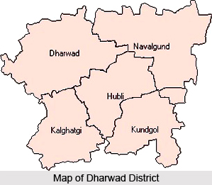
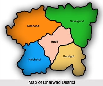
Dharwad district is an important district in the southern state of India, Karnataka. It is strategically located in the northern part of Karnataka almost equidistant from the two industrial centres of India- Bangalore, the capital city of Karnataka and Pune, a rapidly developing industrial city in Maharashtra

The district headquarters is located at Dharwad. Dharwad means a resting place after a long travel and is an appropriate name as it acted as a gateway between the Malenaadu and the Bayalu plains and became a resting place for the travellers. The district has a temperate climate and is surrounded by numerous lakes, hills and other small water bodies. The major lakes are Kelgeri and Sadankeri.

In 1961, the town merged with the neighbourhood town Hubli to become a single municipality, Hubli- Dharwad. In 1997 two new districts Gadag District and Haveri district were created out of Dharwad`s administrative territory. A part of Dharwad district was coalesced with lands, which were earlier, the part of three other districts in order to make the new district of Davanagere.

Historical records say that the Chalukyas ruled Dharwad in the 12th century and at that time it was an important city. Having a historical connection, the town has many temples and is an important religious centre. Someshwara Temple, Murugha Math, Shankara Matha, Dattatreya Temple, Vanavasi Rama Mandira, Ulavi Basappana Temple, Laxmi-Narayana Temple, Tapovan, and Renuka Devi-Temple are some of the famous temples of the district.

The Dharwad district is also the home of many prestigious educational institutions like the Karnataka University, the Karnataka Medical College and the University of Agricultural Sciences. It is also known for `pedas`, a sweet made from milk.

Hubli, is an important commercial city of the district with its many cotton and silk factories, railway workshops, and a major newspaper industry. Along with Hubli, which is situated at a distance of 22 kms.from Dharwad forms a twin city.


Geography Of Dharwad District

Geography Of Dharwad District, Karnataka
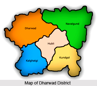
Dharwad district is situated in the Western sector of the northern half of Karnataka State. The District encompasses an area of 4263 Sq.Kms, and lies between the latitudinal parallels of 15 degrees 2 minutes and 15 degrees 51 minutes North and longitudes of 73 degrees 43 minutes and 75 degrees 35 minutes East. The district is bounded on the North by the Belgaum district, on the East by the district of Gadag District, on the South by the Haveri district and on the West by Uttara Kannada district. All these districts, which surround Dharwad district, belong to the state of Karnataka itself.

The District lies approximately about 800 metres above the sea level, which is why it enjoys a moderate and healthy climate. The District may be divided into 3 natural regions, viz., the Malnad, Semi-Malnad and Maidan. These regions, on an average, receive moderate to heavy rainfall and have dense vegetation. Kalghatagi and Alnavar area in Dharwad taluka in particular receive more rainfall than other talukas of the District. The mineral and forest wealth of the district is not too impressive.

The demographics of the place is such that the population forms quite a mix of cultures. The district is a place for people belonging to various religions like Hinduism, Islam, Jainism and Christianity. Hindus, in particular, are spread across rural and urban areas. The widely spoken language in the district is the Kannada language, while a thin population is found using languages like Urdu, Marathi, Hindi, Telugu, Gujarati and Malayalam.

Agriculture forms a major activity in this part of the district. Perhaps this can be explained by the fact that the region falls under the Tropical Region which is why it is widely affected by monsoons. In fact the economy itself is an agro-based economy. The main soil type found here is black soil which helps in raising crops like cotton, wheat, Ragi, Jowar and oilseeds. The red soil which is also found here is more suitable for paddy. Among these, the main kharif crops are cotton, chillies, sugarcane and groundnuts, and the main Rabi crops are jowar, wheat, rice etc. The prestigious University of Agricultural Sciences at Dharwad has discovered new species of cotton and chilies, which is the first of its kind in the world. Therefore other activities of economy, i.e., trade and commerce are completely dependent on agriculture. As monsoon is highly uncertain in nature and as there is no major irrigation project or any hydel power generating station in the district, there is high degree of dry-land farming.


Administration Of Dharwad District

Administration Of Dharwad District, KarnatakaAdministration of Dharwad district is the overall responsibility of the Deputy Commissioner. The Deputy Commissioner`s office comes under the revenue department which looks after the overall administration and maintenance of law and order of the district. The Collectorate consists of various branches headed by Srishtedars/ Deputy Tahsildars or managers who are responsible for supervision, guidance and overall management of work in their respective branches. Every branch consists of first Division Assistants and Second Division Assistants among whom all the work of the department is divided.

The department deals with implementation of Agrarian reforms act like Land Reform Act and various related acts like Village Office Abolition Acts. It also deals with distribution of surplus land to poor tenants, agricultural labourers etc. The department is responsible for acquisition of land for public purposes like irrigation projects, power projects etc. It also processes various requests for grant of land to individuals and organisations. The department also administers Department of Survey and settlement and Department of Stamps and Registration. Broadly speaking, there are various sections of the Deputy Commissioner`s Office which deal with the various functions. These are:

Administrative Section: Which deals with the matters relating to vacancies, appointments, pay and allowances, transfers and promotions, postings, retirements, CCA (Classification, Control and Appeals), Personal Deposit Accounts, Audit Reports, DC Diary and Business Statistics.

Revenue Section: This section deals with jamabandi, DCB (Demand Collection and Balance), Land Grants, Land Acquisition, Land Conversion, PTCL, Appeals, Land Reforms cases, Mines and Minerals and Regularisation of encroachments.

Election Section: This section deals with Election matters pertaining to Loksabha, Vidhansabha, Vidhanparishat, all local body elections such as Grama Panchayat, Taluk Panchayat, Zilla Panchayat, Municipalities, APMC, and other co-operative institutions.

Municipal Section: This section deals with all Municipal matters including service matters, progress made under various schemes like SJSRY (Swarna Jananthi Shahari Rozgar Yojana), IDSMT (Integrated Development of Small and Medium towns), Water supply schemes, Housing schemes and Slum Area Development.

Muzarai Section: This section deals with construction and renovation of Muzarai temples, appointment of Dharmadarshies and payments to Archaks` (Tasdik and annuity) salary, Aradhana Schemes.

Census Section: This section deals with census matters.

Judicial Section: This section deals with judicial matters such as Law and Order (Section 144 etc.,) issue of licenses for Arms and Ammunitions and Cinemas.

Miscellaneous Section: This section deals with NSAP, OAP, PHP, MPLAD and other Schemes. It also deals with meeting statistics, PWD works, and issue of income and caste certificates, House Rent Control (HRC) and other miscellaneous matters of Revenue Department.

There are various officials both at the district level and at the taluk levels to assist the Deputy Commissioner. They include the Assistant Commissioner (Sub-Divisional Magistrate), Tahsildars, Shirstedars/Deputy Tahsildars, Revenue Inspectors and Village Accountants. The Deputy Commissioner Court deals with cases pertaining to Revenue Appeals, Revenue Miscellaneous ( KLR Act, 1964 ), Prohibition of transfer of Certain Lands cases ( PTCL Act,1978 ) and inam cases( Inam Abolition Act ). One SDA and Manager of Judicial Branch assist the D.C by doing back-office work.

For the purposes of rural administration, the Dharwad district also has a Zilla Panchayat. The Dharwad Zilla Panchayat is a three-tier Panchayat system with elected bodies at the Grama, Taluka and district levels constituted as per the 73rd amendment to the constitution for greater participation of the people and more effective implementation of rural development programs (and to function as units of local self government). The Zilla Panchayats were constituted as per the provisions of The Karnataka Panchayat Raj Act, 1993. The Zilla panchayat structure and activities are listed below.

Dharwad Zilla Panchayath is an elected body constituted of the following members: 1. 22 Members are elected from geographically demarcated constituencies from within the rural areas of the district.
2. 2 Members of Parliament of the district.
3. Members of State Legislative Assembly and State Legislative Council for the district.
4. The Adyaksha of five Taluk Panchayats of the district.

To facilitate greater discussion in the functioning of zilla panchayat, 5 standing committees have been formed. For smooth functioning and administration of the zilla panchayat office, an officer designated "Chief Executive Officer" is appointed by the state government to carry out administration of Zilla Panchayat. Chief Executive Officer is designated head of department for all the department offices within the Zilla panchayat. He is assisted in the discharge of his duties by Senior Officers in the Zilla Panchayat. These include the Deputy Secretary, Chief Planning Officer and Chief Accounts Officer. The Zilla Panchayat deals with a number of different functions which broadly deal with development, administration, planning, accounts and council section.


Temples of Dharwad District

Temples of Dharwad District, Karnataka
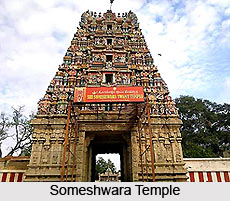
The lovely temples of Dharwad district in Karnataka are tourist spots and heritage sites of the state attracting thousands of devotees throughout the year. Dharwad District is strategically located in northern Karnataka and the history of the temples of Dharwad district can be traced back to the 12th century. The district is dotted with many hills, lakes, and other smaller water bodies. The famous temples of Dharwad district include Murugha Math, Someshwara Temple, Laxmi-Narayana Temple, Shankara Matha, Dattatreya Temple, Ulavi Basappana Temple, Vanavasi Rama Mandira, Tapovan, and Renuka Devi-Temple.

Bannikoppa Jain Temple is one of the important temples of Dharwad district and was constructed in the 1940`s under the guidance of Sri Payanagara Maharaj. The authorities reconstructed the temple and the Pancha Kalyana Mahotsav was held here in 1976. The temple`s sanctorum has a 2 feet tall idol of Bhagwan Sri Parshwanatha, which is the main deity. The temple enshrines the honored idols of Sri Parshwanatha, Siddakuta and Siddachakra. The temple walls are designed with architectural marvels.

Kartikeya Temple is a famous temple of Lord Muruga in the Dharwad district. Located on a hill near Sondur, this is one of the temples of Dharwad district that houses the famous Heramb Ganesh temple within its premises. Someshwara Temple is one of the most visited temples of Dharwad district that was built in 12th century by the Chalukyas. Someshwara Temple is one of the notable landmarks in the district. This temple houses statues of Mahishasuramardini and Chaturbhuja Ganesh, where Ganapathi is represented with four hands. The river Shalmala originates near by the temple but she flows under ground.

The surroundings of the temples of Dharwad district are abound in natural beauty. They depict the south Indian architecture at its best.


Share this Article:

Related Articles

More Articles in States of India


East Indian States
East Indian States comprises of Bihar, Jharkhand, West Bengal, Odisha and also the Union Territory of Andaman and Nicobar Islands. It defines the cultural heritage, rich historical background and the linguistic unity.
Erode District
Erode District is one of the districts in the state of Tamil Nadu. The district of Erode is having a land-locked area with no sea coast.
Purnia District in Bihar
Purnia District is located in Bihar and extends from River Ganga to Nepal. The district has a rich Hindu history and glorious past.
South Delhi District
South Delhi District is the third largest district of Delhi as far as its area is concerned. South Delhi District is known for its economic, historical, cultural and social significance.
North Indian States
North Indian States formed the cultural and religious unity in spite of having many foreign invasion and the political disturbances from the early era till the British gained supremacy in Indian sub continent.
Kendujhar District
Kendujhar District, spread over an area of 8,240 sq kms, is as varied as the whole of Orissa with waterfalls roaring gorges, mountains and minerals. The manifold expressions of nature in Kendujhar District are considered as unique.
Hooghly district
Hooghly District along the bank of the river Hooghly is one of the principal trading ports of West Bengal.
Districts of South Tamil Nadu
Districts of South Tamil Nadu consist of many tourism destinations like archaeological sites and the history of Pandyas and Cholas. Considering their proximity to the sea, many districts also boast of serene beaches and coastal beauty.
Flora of Arunachal Pradesh
Flora of Arunachal Pradesh includes infinite species and is a subject of great interests for the botanists.
Districts of South Gujarat
Districts of South Gujarat are the epicenter of Jain pilgrimages and the early Hindu kingdoms.
North West States of India
North West States of India consist of three states, which are Rajasthan, Punjab and Haryana. All of them are culturally and traditionally diverse and they have been ruled by different dynasties in historical time.
Geography Of Chittoor District
Geography of Chittoor district is spread along the topography of the land which is divided into two natural divisions; Chittoor has a dry and healthy climate.
Districts of North Rajasthan
District of Northern part of Rajasthan is dotted with ancient forts and medieval villages.
Districts of North Odisha
District of North Odisha has Bengal boundary and shares the same culture. These are reachable if one pays a weekend visit to Digha.
Districts of West Bihar
Districts of West Bihar is comprised of medieval monuments that were built by the different governors of Mughal era.
Districts of South Haryana
Districts of South Haryana consists of many cities of industrial excellence. These districts are dotted with popular tourism destinations.
Medieval History of Assam
Medieval history of Assam narrates the advent and rule of a number of kingdoms in the region. The prominent dynasties of the kingdom left an everlasting imprint on the socio cultural heritage of India.
Geography of Meghalaya
The suitable climate, highland plateaus, rivers and the flora and fauna together forms the geography of Meghalaya.
Districts of Rayalaseema
Districts of Rayalaseema in Andhra Pradesh state has urban population and rural settlements as well.
Districts of South Punjab
Districts of Southern part of Punjab depict medieval history of Punjab and the rise of Sikhs.