Introduction
Provinces of British India, also known as Presidency towns, were the administrative offices and units of the territories of India which were under the sovereignty of the British East India Company and later the British Government of India between the period 1612 and 1947. After the great revolt of 1857, the British Empire in India acquired dominance and initiated direct rule under the British Crown. During the 19th century and 20th century, the British Government comprised of 8 provinces which were managed and administered by a Lieutenant Governor or a Governor. The 8 major provinces of British India included Burma, Bengal, Madras, Bombay, United Provinces, Central Provinces and Berar, Punjab and Assam. In the period between 1905 and 1912, a province of Eastern Bengal and Assam existed during the partition of Bengal. Later a new Lieutenant Governor`s province of Bihar and Orissa was formed as well.
Moreover there were some minor provinces of British India were well which were under the administration of a Chief Commissioner. These included North West Frontier Province, British Baluchistan, Coorg, Ajmer Merwara, Andaman and Nicobar Islands. At the time of Indian independence in the year 1947, the British administration consisted of 17 provinces of British India, namely, Ajmer Merwara Kekri, Baluchistan, Bihar, Coorg, Orissa, United Provinces of Agra and Oudh, Andaman and Nicobar Islands, Bombay Province, Assam, Delhi Province, North West Frontier Province, Central Provinces and Berar, Panth Piploda, Sindh, Madras Province, Punjab and Bengal Province.
During the Partition of India into the Dominion of Pakistan and the Union of India, 12 provinces, including Assam, Ajmer Merwara Kekri, Bombay, Andaman and Nicobar Islands, Bihar, Central Provinces and Berar, Panth Piploda, Coorg, Orissa, Delhi, Madras and the United Provinces, became part of the Indian Union. The 3 provinces of Sindh, North West Frontier and Baluchistan became a part of Pakistan. The 2 provinces of Punjab and Bengal were divided between India and Pakistan.
After the adoption of the new Constitution of India in the year 1950, the provinces in India were replaced by restructured and redrawn states and union territories. In 1956, the province of East Bengal in Pakistan was renamed as East Pakistan and later became the independent country of Bangladesh in the year 1971.
United Provinces of British India
The United Provinces of British India was one of the former British provinces that were under the rule of the British Empire in India. The United Provinces of British India was also known as United Provinces which was established on 3rd January 1921. The territory came into existence as a consequence of the renaming of the United Provinces of Agra and Oudh, which existed from 1902 to 1947. The region matched roughly to the united territories of the modern Indian state of Uttar Pradesh and the state of Uttarakhand.
On 1st April 1937, the United Provinces of British India ceased to exist when it was officially renamed as the United Provinces by the Government of India Act 1935.
Ajmer Merwara Province of British India
The Ajmer Merwara Province was one of the erstwhile provinces of British India in the region of Ajmer. The Province was scattered over a total area of 7,000 sq km. The town of Ajmer is located on the center of a plateau which is regarded as highest point in the plains of North India On June 25, 1818, the area was ceded by a treaty to the British East India Company by Daulat Rao Scindia. After the Indian independence and the Partition of India in the year 1947, the territory of Ajmer Merwara was maintained as a province under the newly formed Union of India, also known as the Dominion of India. Later in the year 1950, the former province became the Indian state of Ajmer. The region was incorporated as part of the state of Rajasthan on 1st November 1956.
History of Ajmer Merwara Province
Before the advent of the British East India Company, the Rajputs, the Rawat Rajputs, Cheetas, the Kathats and the Jats ruled over the region and operated as cultivators. The native rulers of the Rajputs and Rawat Rajputs held the title of Thakur. The Thakur of Kharwa and the Thakur of Masuda were the most outstanding Rajput Thikanas of the Mertia dynasty. Where as, the Merat Rajputs held the title of Khan, like the Khan of Athun, a prominent Thikana of the Kathat dynasty. The Jat rulers used the title of Chaudhury, who acted as village chieftains.
A portion of the region under the province was ceded by Daulat Rao Scindia to the British administration as part of a treaty in 1818. Since then the Ajmer Merwara Province was managed directly by the British East India Company. After the great revolt of 1857, the authority and powers of the Company was reassigned to the Governor General of India and the British Crown. The province comprised of the Ajmer and Merwara districts that were geographically separated by the various princely states of Rajputana Agency, from the rest of British India. But unlike these princely states of India, which were administered by the native rulers or Indian Princes who accepted the suzerainty of the British Government of India, the Ajmer Merwara Province was governed directly by the British authorities.
It was ruled by the British East India Company until 1858 and after the year 1858, the province was administered by a Chief Commissioner who was a subordinate of the Resident of British India (Political Agent) to the Governor General of India for the Rajputana Agency. After independence in 1947, the province came under the Union of India and later in the year 1956, it was merged with Rajasthan.
Chief Commissioners of Ajmer Merwara Province
Richard Harte Keatinge (1871- 1873)
Sir Lewis Pelly (1873- 1878)
Edward Ridley Colborne Bradford (1878- 1887)
Charles Kenneth Mackenzie Walter (1887- 1890)
George Herbert Trevor (1890- 1895)
Robert Joseph Crosthwaite (1895- 1898)
Arthur Henry Temple Martindale (1898-1905)
Elliot Graham Colvin (1905- 1918)
John Manners Smith (1918- 1919)
Robert Erskine Holland (1919- 1925)
Stewart Blakeley Agnew Patterson (1925- 1927)
Leonard William Reynolds (1927- 1932)
George Drummond Ogilvie (1932- 1937)
Arthur Cunningham Lothian (1937- 1944)
Hiranand Rupchand Shivdasani (1944- 1947)
Central Provinces of British India
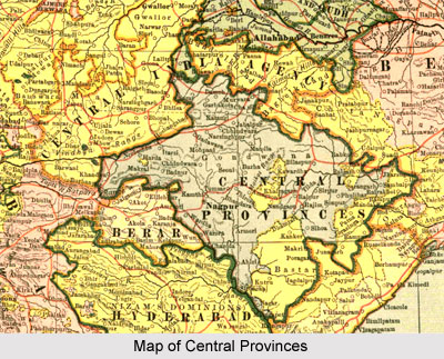 The Central Provinces was an erstwhile province under the rule of the British Empire in India. The territory contained British occupations from the Mughal Empire and Maratha Empire in central India. It also included various parts of the present state of Madhya Pradesh, Maharashtra and Chhattisgarh states. Nagpur was the capital of the province in British India. The Central Provinces was established by the unification of the Nagpur Province and the Saugor and Nerbudda Territories in the year 1861. The territory was bounded by several princely states of India like the princely state of Bhopal and Rewa state in the north; the princely state of Kalahandi and the Chota Nagpur state in the east; Berar state in the west; and Nizam`s territories of Hyderabad in the south. The region of Berar of the princely state of Hyderabad was annexed to the Central Provinces in 1903.
The Legislative Council of the Central Provinces in British India was established on 8th November 1913. The Council continued for Chief Commissioner of the Central Provinces. The Central Provinces Legislative Council continued for the Governor of the Central Provinces between the period 1920 and 1936. Later, after the year 1936, the Legislative Assembly of Central Provinces and Berar was created. The territory became the new province of Central Provinces and Berar on 24th October 1936. After the country achieved independence and the withdrawal of the British Government of India on 15th August 1947, several former princely state of India were merged with the Central Provinces and Berar province. After the new Constitution of India went into effect in the year 1950, the erstwhile Central Provinces formed the new Indian state of Madhya Pradesh, which had Nagpur as its capital. In the year 1956, some of the regions of Madhya Pradesh, which included the Berar and Nagpur divisions, were incorporated as a part of Bombay state.
In 1960, the Bombay state was restructured, with the Gujarati-speaking regions becoming Gujarat and the Marathi-speaking regions forming Maharashtra. Later in the year 2000, the eastern part of the state of Madhya Pradesh was segregated in order to from the new Indian state of Chhattisgarh.
Panth Piploda Province of British India
The Panth Piploda Province was one of the former provinces of British India. At present, the territory is located in the district of Ratlam in the central Indian state of Madhya Pradesh. Panth Piploda was amongst the smallest provinces under the rule of the British Empire in India, which covered a total area of 65 sq km. It comprised of a total population of 5267, of which 2666 were males and 2601 were females, according to the census of India in the year 1941. The British province was situated in the Malwa region and comprised of various separate enclaves, which were bordered by the erstwhile Indian princely states of Dewas, Gwalior and Jaora. The Panth Piploda Province was administered and managed by a Chief Commissioner of British India who was appointed by the Governor General of India. Lieutenant Colonel Sir Walter Fendall Campbell KCIE served as the Chief Commissioner of Panth Piploda region from May 1942 to August 1947.
History of Panth Piploda Province
The Panth Piploda Province was a diminutive and undersized tract of land that consisted of around 10 villages, which were governed and ruled by 5 distinct native rulers who held the title of Thakur. In the year 1765, the Peshwa of the Maratha Empire transferred the revenues from the local villages to the family of a Karadhe Brahmin named Sambhaji Attaji. They later became the ruling family of the territory and later became renowned as the family of the Khandekar Pandits. The reassignment of the revenues made by the Peshwa of the Maratha Empire was accepted and appreciated by the British Government of India when seized over the region of Panth Piploda and took charge of the administration from the Maratha Empire in the year 1817.
The ruling family of Panth Piploda Province did possess any proprietary rights whatsoever in the villages located within the territory. They acted as mere recipients of the cash allowance and revenues, known as Tankadars. The cash allowance was paid to the native rulers by the Resident of British India, also known as Political Agent, who was placed in the Malwa Agency. The British resident realized it from the Thakurs in whose territories the villages were located.
The estate was supervised and administered by a Superintendent who operated under the authority of the Resident of British India with headquarters at Kharua. In the year 1936, there were 2 guaranteed Tankadars, who were granted allowance and payments of a huge sum. Panth Piploda was appointed as province in the year 1942, under the dominion of the British rule.
Assam Province of British India
The Assam Province was one of the prominent provinces of British India and is also amongst the original provinces of contemporary India, comprising of a legislature which dates back to the year 1937. At present Assam a northeastern state in India and is a geographically and culturally distinctive region. The present state of Assam has experienced several territory alignment modifications and the state map has been changed numerous times. The territory played a very significant role during the Indian freedom struggle. The Assam Province was well known for natural resources and the current capital of the state is at Dispur. The province was situated in the south of the eastern Himalayas. The present Indian state is bounded by 7 of the renowned Seven Sister States, namely Meghalaya, Tripura, Mizoram, Manipur, Nagaland and Arunachal Pradesh. The territory also shares borders with Bangladesh and Bhutan. The Assam Province was one amongst those main 8 provinces of British India.
History of Assam Province
In the year 1821, Chandra Kanta Singh, the native king accepted the dominion of the British East India Company. As a result the Burmese army invaded the province defeated the Assamese forces in 1822. Thus the province of Assam was appointed as a Burmese province which was managed by a military Governor General. After the end of the First Anglo Burmese War under the Treaty of Yandabo in 1826, the British authorities took charge of Lower Assam and installed Purander Singh as the native ruler of Upper Assam in the year 1833. But after 1838, the British East India Company eventually annexed the whole territory. At first, the province was included into the Bengal Presidency, but in 1906, it became a part of Eastern Bengal and Assam province. Later in the year 1912, the region was restructured as a province of the Chief Commissioners. In 1913, a Legislative Council and in the year 1937 the Assam Legislative Assembly were established in Shillong, which was its former capital.
During the partition of Bengal through 1905 to 1911, the new province of Assam and East Bengal was created as a Lieutenant Governorship. In East Bengal was reunited with Bengal in 1911 and the regions of Orissa, Bengal and Assam became the new provinces in the east. After the nation gained independence in the year 1947, Assam Province, along with Meghalaya, Mizoram, Nagaland and Arunachal Pradesh, was incorporated as a state of the newly formed Union of India.
Nagpur Province of British India
The Nagpur Province was one of the major provinces of British India that were under the rule of the British Empire in India. The territory was scattered over the area of the modern day states of Chhattisgarh, Maharashtra and Madhya Pradesh. The Nagpur Province of British India was established in the year 1853 when the British Government of India annexed the princely state of Nagpur. Later in 1861, the province was merged with the Central Provinces. The capital of the Nagpur Province was at the city of Nagpur. The Nagpur Province comprised of the areas of the Maratha Bhonsle Maharajas of Nagpur, influential members of the Maratha Confederacy who occupied expanded areas of central and eastern India during the 18th century.
In the year 1818, after the culmination of the Third Anglo Maratha War, the Maratha Bhonsle Maharaja surrendered to a subsidiary alliance. Consequently, the territory of Nagpur was appointed one of the princely states of India that was under the suzerainty of the British Empire in India. After the death of Raghoji III in 1853, the region of Nagpur was annexed by the British East India Company under the Doctrine of Lapse, as the native ruler had no heirs. The Nagpur Province, which consisted of the Nagpur division, Chhattisgarh and Chhindwara, was administered by a Commissioner under the Governor General of India, who followed orders of the Central Government till the creation of the Central Provinces in the year 1861. The Province of Nagpur also included the districts of Bilaspur, Raipur, Durg, Balaghat, Wardha, Chanda, Bhandara, Nagpur and Chhindwara.
The Saugor and Nerbudda Territories were merged with the British province of Nagpur in order to constitute the new Central Provinces in the year 1861. The Saugor and Nerbudda Territories were constituted under the Governor General in 1820 and was later included in the newly formed North Western Provinces in the year 1835. The erstwhile districts of Balaghat, Wardha, Chada, Bhandara and Nagpur eventually formed the Nagpur Division of the new province; where as Bilaspur, Raipur and Durg formed the Division of Chhattisgarh. Later, Chhindwara district was included into the Nerbudda (Narmada) Division.