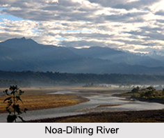
 Miao is a sub-division in the Changlang District of Arunachal Pradesh located 25 km away from the Assam border. It is located at 27.49 degrees north and 96.20 degrees east. Miao is located in one of the regions in North East, which gets heaviest rainfall. Noa-Dihing River is flowing through the region and Miao has the Patkai mountain range in it, which is the eastern extension of the Himalayan Mountain Ranges. Miao region covers the Diyun and Chowkham towns, which are inhabited by the Chakmas and Khamptis. Chowkham is popular for plywood and opium cultivation.
Demography of Miao
The dominant tribes of this region are Tangsa, Singpo and Lisu. A group of Chakma people and Tibetan refugees has also made their settlements here. Chowkham is predominantly inhabited by the Mishmi tribal people.
Religion in Miao
Along with the tribal people, there are many Christians as well in Miao. Miao Town Baptist Church is one of the first established churches here. There are also Revival Church, Church of Christ and Catholic Church. There are Hindu temples in Miao as well. And there is a Rangfrah, indigenous religion also in Miao.
Tourism in Miao
Apart from the scenic views of Noa-Dihing River, Miao has several other tourist spots, which are Namdapha Tiger Project, forest museum, wildlife library, Mini Zoo etc. Deban is the prime tourist spot near to Miao, which is located 25 km away from the region. People of this region are engaged with Jhum cultivation and tea plantation.
Visiting Information to Miao
Tinsukia Railway Station (115 km) and Dibrugarh Airport, Assam (156 km) are the nearest to reach Miao. Regular APSTS and ASRTC buses and cabs are available from Dibrugarh, Tinsukia and Margherita to Miao. National Highway 27 connects Miao to other parts of the country.
This article is a stub. You can enrich by adding more information to it. Send your Write Up to content@indianetzone.com.


