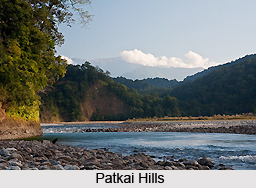
 The patkai hills are situated on India`s north-eastern border with Burma. The hills are located at an elevation of 1,223 meters above sea level. Its coordinates are 27 degree 0`0" N and 96 degree 0`0" E in DMS (Degrees Minutes Seconds) or 27 and 96 (in decimal degrees). The Indian states along the Patkai range comprise of Assam, Manipur, Meghalaya, Mizoram and Nagaland.
The word "patkai" means "to cut chicken" in Tai-Ahom language. The hills were originated by the same tectonic processes that resulted in the formation of the Himalayas in the Mesozoic. The Patkai hills are crammed with conical peaks, steep slopes and deep valleys but they are not as rough as the Himalayas. The whole region is surrounded by forests comprising of sandstones.
Patkai includes three hills namely the Patkai-Bum, the Garo-Khasi-Jaintia, and the Lushai Hills. The Garo-Khasi-Jaintia range is located in Meghalaya. Mawsynram and Cherrapunji are situated on the windward side of these hills. Having the highest annual rainfall, these two are the world`s wettest places. The climate of the Patkai hills varies from temperate to alpine due to the different altitude.
The Dehing River flows down from the Patkai mountain range and meets the Brahmaputra in Assam. Both Patkai and Dehing, contribute their natural resources to numerous tribal communities that inhabit the hill ranges. The Namdapha National Park is bordered by the Patkai hills in the south and south-east. This is an important tourist spot.
The most ideal route to Patkai hills is provided by the Pangsau Pass. The Ledo Road was constructed through Pangsau Pass as a strategic supply road established over the range at the time of World War II to link India with the Burma Road into China.
This article is a stub. You can enrich by adding more information to it. Send your Write Up to content@indianetzone.com