 The state of Meghalaya is located in the north eastern part of India. The geographical terrain of this state is characterized by highlands, rivers, waterfalls and forests. These, along with a variety of flora and fauna, national parks, wildlife sanctuaries, sacred groves, caves, etc have not only beautified this state, but also draw tourists here. Lakes in Meghalaya are no exception in this regard. They too have added value to the tourism in this state.
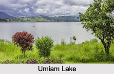
Umiam Lake
Umiam Lake or Barapani or Big Water is located about 15 km north of Shillong. Characteristically, it is a man made or artificial lake and a reservoir created by damming the River Umiam. This lake is also recognized as the first hydel power project in the north-eastern region of India. This lake is graced by the surrounding coniferous forests. This lake provides ecosystem services at micro, meso and macro levels. It is responsible for power generation in Meghalaya and supports downstream irrigation, fisheries and provides drinking water. This lake allows kayaking, water cycling, scooting and boating.
 This lake has turned into a dumpsite, with urban waste being released into it, without any prohibition. Polluted river systems feed the Umiam and have changed its biological nature. An estimated 40,000 cubic meters of silt enter Umiam Lake every year. Upstream encroachments, deforestation, blockage of natural drainage systems and unscientific mining in the catchment area are some of the other reasons deteriorating the quality of this lake.
Umhang Lake
Umhang Lake is located in Batow village on the hills of the district of Jaintia. The people living in the village of Batow consider the Umhang Lake to be sanctified. Hence, they do not use it for other purposes. Annually, they offer sacrifice on the banks of the lake. The Umhang Lake is known to have the resemblance of a gem in a perfect setting of a sylvan. The banks of the Umhang Lake are bedecked and surrounded by dense green forest. History highlights that the Umhang Lake was formed by Chieftain, U Sajar Nangli and his followers.
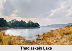
Thadlaskein Lake
Thadlaskein Lake is located about 56 kilometers from Shillong. This historical lake is known to be constructed by the followers of the Jaintia Chieftain, U Sajar Nangli, who also constructed the Umhang Lake. This lake provides scope for picnic and is also utilized for boating.
Wards Lake
Wards Lake or Pollock"s Lake is located in Shillong. This artificial lake serves as a home to a variety of colorful fishes. A wooden bridge on this lake adorns it. Boating is a fun filled possibility on this lake.


