Introduction
 Mathura District in Uttar Pradesh is situated along the banks of the Yamuna River. The historic town of Mathura is the district headquarters.
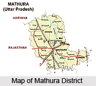
Location of Mathura District
Mathura District is a part of Agra division. Mathura District is bounded on the northeast by Aligarh District, on the southeast by Hathras District, on the south by Agra District, and on the west by Rajasthan and northwest by Haryana, another Indian state. Mathura district is an important pilgrimage centre of Hindu community.
History of Mathura
 History of Mathura covers with the myths on Lord Krishna. This ancient city in Uttar Pradesh came into existence from the time of early Vedic period. This place of ancient historical beauties is mentioned in Ramayana and Mahabharata, the Indian epics.
Mathura is related with stories of Lord Krishna, his birth and the part of his life he spent there with Radha, the consort of Iyan Ghosh.
Mythological History of Mathura
Once, there was king named Ugrasena, who ruled over Mathura. Once Ugrasena and his wife were taking a walk in the gardens when a demon saw the queen and fell in love with her. In his desire for the queen he diverted Ugrasena, assumed his form. From there, a child was born of this union was Kansa. Kansa grew up and dethroned his father and imprisoned his cousin, Devaki. While driving Devaki and her husband Vasudeva in his chariot, Kansa heard a voice in the sky (akashvani) telling him that he was carrying a woman whose eighth child would kill him. Kansa immediately prepared to till Devaki. But Vasudeva arbitrated and begged for her life. Vasudeva promised to Kansa that they would hand over all their children to him soon after their birth. So Kansa imprisoned them and killed seven children.
 Early History of Mathura
Before the advent of Gautama Buddha and his philosophy, the place where Mathura is located was called Surasena. It was 6th Century BC. In Buddhist literature, Mathura is called Madhura. It was also known as "Mathera". Mathura was a prosperous city and the capital of a large territory. A Buddhist centre was established in Mathura during the reign of the Maurya dynasty. This centre existed for a few centuries. Emperor Ashoka made many Buddha stupas in Mathura on the bank of the Yamuna River. Kanishka, the Saka Emperor in the first century BC and his successors constructed many Buddhist stupas and chaityas to foster the Buddhist philosophy in that region.
In the early times, Mathura was the largest city in North India. Mathura was serving as the capital city for the area for administration. During these times the present town of Vrindavana was the dense forest. In the beginning of the 5th century AD the Chinese traveller Fahien saw 20 Buddhist monasteries and 3000 Buddhist priests living in Mathura. By the middle of the 6th century AD Buddhism started to decline in the Mathura area. Many Buddhist relics have been found in the Mathura area.
Medieval History of Mathura
The Sultan of Delhi, Mahmud Ghazni invaded Mathura in 1018. He plundered many buildings and temples in Mathura. It took his men 20 days to plunder the city. He took 5,000 prisoners and took over 30 million rupees. He took so many statues of gold and silver and jewellery that it took over 100 camels to carry everything that he took. Tarikhi Jamina wrote a record of Mahmud Ghazni in which he described Mathura at the time that it was attacked.
 During his rule, Pherose Khan Jughalak, who ruled from 1351 to 1388, destroyed all the Hindu temples that were within the territory that he ruled. While he ruled no one was allowed to go on pilgrimage to holy places or allowed to bath in a sacred place. From the eleventh century until the end of the sixteenth century temples in Braja were periodically destroyed. Sikandar Lodi, who ruled from 1488 to 1516 first duty after conquering a place was to destroy all the temples there. He attacked Mathura in 1500. Indian Sufi saint, Chaitanya visited Vrindavan in 1514 during the rule of Sikandar Lodi.
Modern History of Mathura
The region of Mathura was added to British territory in 1803. Till 1832, when Mathura was recognised as district, the region was partly administered from Agra and partly from Sadabad. The land of Braj starts from Kotban near Hodel about 95 km from Delhi and ends at Runakuta which is known specially for its association with the poet Surdas, an ardent devotee of Lord Krishna devotee long line of picturesque Ghats - with their steps leading to the water`s edge, arched gateways and temple spires extending along the right bank of the Yamuna River, emphasise the sacred character of the town of Mathura.
Geography of Mathura District
Mathura is located at 27.28 degree north to 77.41 degree east. It has an average elevation of 174 metres from sea level. The climate of Mathura is tropical extreme type with very hot summers with temperatures rising beyond 44 degree Celsius. The cold and foggy winters in Mathura District, with temperature dipping to 5 degree Celsius attracts the nature loving tourists also. The average rainfall is 593 mm, received mostly during the monsoons from July to September.
Population of Mathura District
The Population Census of 2011 stated that in Mathura district there was a population of 2,541,894. This gives Mathura District a ranking of 167th in India, out of a total of 640 districts in India. The district has a population density of 761 inhabitants per square kilometre. Its population growth rate over the decade 2001-2011 was 22.53 percent. Mathura has a sex ratio of 858 females for every 1000 males. The literacy rate of Mathura District is 72.65 percent.
People of Mathura District
 Mathura District with its headquarters at Mathura city is a Jat dominated region with around 3 lakh Jats. Mathura City receives a large number of daily visitors besides pilgrims who stay for an average of 3 days. The urban area of Mathura is dense and the urban population ranges between 100,000 to 125,000 per day, whereas on festive and auspicious days it is over twice the population of urban area. People in Mathura and nearby areas speak Braj dialect (Braj Bhasa).
Mathura City
In the Puranas it is stated that Mathura is a holy city founded by Satrughna who was the younger brother of Lord Rama. Mathura is situated in the banks of the river Yamuna, where a demon named Madhu resided. His son is the Rakshasa Lavana, was killed by Satrughna, who afterwards built the shrine, which obtained celebrity as a purifier from all sin. It was in this place that Dhruva`s sacrament was performed.
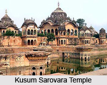
Monuments of Mathura
 Mathura lies about 77 km north of Agra. It is one of the holiest Hindu cities owing to its legendary associations with Lord Krishna. Several religious edifices are the epitomes of Mathura monuments. Some of the well known monumental structures of the region are some religious structures.
The main Islamic monument in the city is the Jama Masjid built by Abd-un-Nabi, Aurangzeb`s governor, and once covered with brightly enamelled encaustic tiles. The courtyard is raised above street level. Over the facade are the ninety-nine names of God and to either side there are Persian inscriptions. The outer pavilions of the mosque are roofed in a typical Hindu style. The four minarets are each 40 m high.
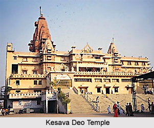
About 400 m beyond is the Katra, a large enclosure within which stands another large mosque of red stone, built by Aurangzeb and used as a shrine. This stands over the ruins of the famous Kesava Deo Temple, which was destroyed by the emperor, although traces of the foundations can be seen at the rear of the mosque.
The old Kans Qila on the river-bank was built by Raja Man Singh of Amber. It was rebuilt by Akbar, but only the foundations remains now. No traces survive of Jai Singh`s famous observatory, which was built here.
The Sati Burj is a square tower of red sandstone with a later plastered dome, 16-8 m high, alleged to have been built after 1574 to commemorate the suttee of a wife of Raja Bhar Mai of Amber. Within the town the fine carved stonework of the facades of many of the houses is worth close inspection.
The Cantonments lie to the south of the city. There are a number of European monuments of importance here. The Anglican Church has some interesting memorial tablets. The Roman Catholic Church of the Sacred Heart was designed in a highly unusual style, combining Eastern and Western architecture. It is by F. S. Growse, the local Collector and exponent of native architecture, who did much to foster a revival of local craftsmanship.
The Cemetery contains a monument to those who fell at the Battle of Deeg in 1804. Nearby is the tomb of Lieutenant C. H. C. Burlton, who was shot by his men during the Mutiny of 1857.
In conclusion it can be said that the city of Mathura has become an important center of pilgrimage not only because it is the birthplace of Lord Krishna but the monuments of the region also add to the tourist attraction of the place.
Sculpture in Mathura
 Sculptural works in Mathura was already in an elevated position, with the thriving kingdom of the Guptas. The place was considered sophisticated, classical and developed with the elite residing there, with abundance of scholarly events in all spheres of life, including art, architecture, writing etc. Buddhist sculptures in Mathura tried to represent the religious aspects of faiths like Jainism, Brahmanism and of course Buddhism. The Mathura art forms, illustrating Buddhist sculpture, is however known to have been influenced by the early Indian art forms of Bharhut and Sanchi. The Gandhara art influence cannot also denied in this respect. Mathura based sculptural works are believed to have incorporated the various aspects of the old folk forms of Yaksha worship and thus paved the way to an enhanced and religious stylisation. The phenomenal Buddha sculptures, portraying a forward stance, are known to be among the best showcases, representing the skilled craftsmanship of the sculptors of Mathura. The archetypal characteristics evidencing the Mathura theme comprise the mannish built, broad shoulders, and rising of the right hand, suggests the abhyamudra. At its helm, Mathura School of Art was highlighted by penetratingly courteous features and streamlined body with refined impression through crystalline garbs, including a dissimilar hairstyle.
In spite of an obviously incessant output, dated sculptures of the 3rd and 4th centuries were practically non-existent in Mathura as elsewhere. Kubera, with its Late Kubera, or a small standing yaksa face, with beautifies of a later date and a bulged chest, riding on over-rounded shoulders, resonant of Udayagiri, for certain belongs to the 3rd or early 4th centuries. So do also the Jain Tirthankaras, with dates in single or double digits, as well as the one in the State Museum, Lucknow. A seated Buddha with likewise unprocessed lions and conferrers on the foundation wears a Gandhara-styled robe, covering both shoulders. On one of the rings of the halo are the extensively and proportionately spaced rosettes, distinctive of the forthcoming century.
During the 5th century. Most seated Mathura images were Tirthankaras. Bases had become much lower in proportion to width and complete with the lions, couchant in posture, their heads facing either the viewer or their own tails.In the centre was a chakra or other religious symbol with kneeling believers on both sides, normally two, their hands in anjali, palms constricted together and held in front of the chest in a signal of greeting intimately, corresponding to the Christian position of the hands in prayer. The solitary Gupta image of a seated Tirthankara, regrettably headless, is dated in the 3rd year of Kumaragupta (422-33). Many figurines were circular in shape. The figure appeared alongside the throne back or simply was edged by ciimara (fly-whisk) carriers, generally raised above the level of the throne.
 They had a rather bisexual, broad-hipped and high-waisted look, and the crossed legs seemed to be twisted downward. Faces accompanied the somewhat hard expressions existing for Buddhas, as well as in 5th century Mathura.
The most extraordinary accomplishment of the Gupta sculptors in Mathura are the standing Buddhas, though most are not quite moving in appeal, owing to a definite tautness. The biggest outlasting absolute example, in the Mathura Museum, is 7ft. (over 2m.) in height; the supreme is now kept in the President`s Palace. The buffalo, however, has overturned itself, as has the goddess, who now stands in the archer`s iitiha posture, her right foot on the buffalo`s head to specify her supremacy. This is the type of which had prevailed hereafter.
The enormous boar panel, measuring almost 22ft. x 14ft. (7 x 4m.), is one of the biggest and the earliest of the immense high-relief scenes, portraying a godly event of mythological or cosmic consequence. Vishnu, incarnated as the boar with a man`s head, is exhibited raising goddess Earth, Bhu Devi, from the primordial waters- one of the most admired myths of manifestation. She is shown supporting against his shoulder, left knee bent, he paces forward and upward in a triumphant posture of conquest. Nagas worship him from the waters. What is more, here at Udayagiri, the myth is exaggerated more than the usual. In low relief on either sides of the focal figure, arises row upon row of sages and ethereal beings, surmounted by a cluster of gods. The lower part of the ground of this Udayagiri (Vidisa) Cave 5, has an incarnation of Vishnu in his Varaha embodiment, belonging to early 5th century, now kept in New Delhi. They stand with a hardly noticeable flexion, the left hand, and palm outward, the right hand, absent in every case, was apparently raised in the `do not fear` signal. Opposing the Sarnath practice, the pleats of the plates of the samgahti are string-like ridges, a resonance of Gandhara architecture, leaving one or two exclusions, they are wrapped unevenly across the chest also. The brilliant haloes comprise concentric bands of immense beauty and `variety`, the outer one usually beautified with the crenels inherited from the early Kusana Buddhas, the second a tube like band, exemplifying a wreath, with episodic rosettes, succeeded by wider bands of the handsome tangentially cut Gupta foliation. In the centre, a multi-petalled lotus beams from the head.
 The discovery of a figurine of similar manner, dated 4358, corroborates the view that these Buddhas forgo those in Sarnath.
The premium Hindu sculpture of the Gupta era, from Mathura, known till now, is a Vishnu, regrettably without legs or lower arms. The others, far less mighty Vishnu images from Mathura are all likewise disfigured. The face could be Buddha`s, but the Herculean chest and shoulders are not those of an ascetic`s. The armbands correspond to those at Udayagiri, but the rest of God`s jewellery, especially the crown, despite their ornamental enthusiasm, requires distinctness, compared to the best early Gupta works. As a matter of fact, they are no more beautifies worn by real people, but they have transformed into a purely sculptural expression- ornamentation of a statue and not of a living god. There are some outstanding Gupta mukhaliizgas (lingas with one or more emerging heads), in museums and collections and in situ in temples at Mathura, and an exquisite Shiva head from a linga subsists detached in the Ashmolean Museum, Oxford.
Rock architecture at Mathura
 Mathura on Piilar " border="1">Yamuna between New Delhi and Agra is of supreme importance when one mentions of the history of Indian sculpture. It was perhaps one of the earliest arts, which was widely sought after and imitated all over northern India only to be rivaled by works of Gandhara. Mathura as mentioned by Ptolemy, was the Seat of the early Kuatrapas and then the Southern capital of the Kuakas, and the abundant remains testify to the important Buddhist and Jain establishments, which flourished under their rule. It also remained one of the main centers of sculptural tradition throughout the Gupta period and beyond. Because of its associa-tion with Krishna`s birth and many of the inci-dents of his early life, Mathura and its environs are still today a major religious center and place of pilgrimage.
Even today, tilas (the local name for large mounds) rise up within the city, probably the remains of stupas unexplored because of the buildings on and around them. As a result, unlike other important sites, not a single early building or monument has sur-vived, even in excavated form. Yet few cities in India can boast of greater antiquity. Through major excavations at Sonkh, a considerable light has been shed on its early cultural and political history of the region.
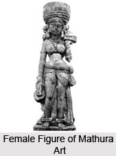
 Many of the stambhas bear the voluptuous pillar figures of women that represent the denizens of the heaven; they are too stereotypical. However, the Nagaraja`s from Mathura have a rich touch to it. It is observed that the Jains produced distinctive cult objects in the form of the sarvatobhadrika images. Some also show figures or scenes or stupas, others are carved with decorative patterns and such ancient Indian symbols as the svastika and the twin fish, adopted by the Jains as well as the Buddhists. But it is the Jain inscriptions that are found more than the Buddhist ones.
The life-size Buddhas especially the largest, installed at srasvati by Bhiksu Bala that is 8 feet 3inches high has a distinctive Mathura features.
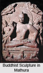
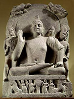 Description of the Buddha statues: The Buddha statues have very little depth for their great size and the backs are flat. They exude a sense of power, with their excessively wide shoulders, their deep navels. They invariably stand with their feet well apart in samapada. The legs so stiff that they appear almost to bend backwards at the knees and usually with a lion or a sheaf of lotuses between the feet. The forehead would bear a mole that was a characteristic trait of Buddha. The right hand usually missing was raised in the same characteristic gesture as that of the seated Buddhas. Small seated Buddhas have been found from Mathura have been found at Ahichchhatra, at sanchi, and as far as Bengal and northwest. It is worth noting that though Gandhara produced Buddha sculptures and images at the same time, it was not as widely spread as the one`s exported from Mathura. Infact, the Gandhara sculptures are found only at Mathura. The stylistic evolution of Mathura sculpture during the first centuries of our era takes place within a much more delimitable period than that of Gandhara.
The seated Mathura Buddhas of the Kusana period are deemed to be more important than the standing ones. This is because, firstly they had a richer iconography than the standing Buddhas, and also they are the finest and the best-preserved forms of Buddha. It is a form, which the great majority of Indian images have continued to make until the present day.
The most famous Buddha idols are shown sitting in a yogic position called Padmasana, with legs tightly folded so that the soles of both feet, decorated with the Buddhist triratna and dharmachakra signs, faced upwards.
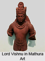
 Hindu idols at Mathura: While the Buddha idols of Mathura are distinctive and famous; the Hindu idols too were not far behind. Infact it was at Mathura during the Kusana period that the first Hindu icons were made. Their appearances coincide with the emergence of the two great Hindu theistic systems, the Saiva and the Vaisnava. Usually small in size, fairly insignificant numbers have survived compared to those of Buddhist and Jain images, but among them two exist in sufficient numbers to be able to speak of anestablished iconography: lingas with one face or four faces of Siva projecting from them, and the goddess Durga slaying the demon buffalo. Small icons of Varaha Visnu recognizable by his characteristic crown, Siva as Ardhanari (half man and half woman), Sasthi and Kartikeya has been found.
The stylistic evolution of Mathura sculpture during the first centuries of our era took place within a much more easily delimitable period than that of Gandhara. Signs of direct contact with the west are not lacking at Mathura. A modified acanthus motif and the olive-leaf band occur widely on door surrounds and lintels. One famous statue, the Hercules and the Nemean lion are indisputably based on a famous Greek or Hellenistic statue extent in dozens of Roman copies. There is no Gandhara sculpture whose source can be so directly traced.
Northern Satraps of Mathura
The Saka power being concentrated in the northwest, Taxila formed the core of the Saka administration. From the numismatics and epigraphic evidences of the Saka era, the names of various Satraps are found. The Taxila copper Plate inscription stated the name of Laika Kusuluka as the satrap of Maues, the Saka king of Gandhara. Kusuluka was the viceroy of the Chhahara (north west of Taxila) region. The son of Laika, Mahadanapati Patika, probably assumed the title of Mahakshatrapa in the later years. According to historians, these satraps of Taxila were related to the Satrap family of Mathura. There was also Satrap Apsavarman serving under Azes II and Gondophernes.
The Mathura kingdom formed the easternmost boundary of the Saka kingdom. From the days of the Mauryan supremacy, the kingdom of Mathura was ruled by the Hindu potentates, who were the provincial governors of the Mauryas. They were supplanted by the Sakas and subsequently the city of Mathura became the headquarter of the Saka-Satrapal family. There is a keen controversy among the scholars about the names of the earliest Saka Satrapas of Mathura. According to Dr. J.N Bannerjee and Dr.D.C. Sirkar, the earliest Scythian Satrap of Mathura was Rajuvala. His coins bear the emblem of a lion and another group of his coins bear the emblem of "Standing Lakshmi" with the Brahmi legends Mahakshatrapa Rajuvulasa and "Abhiseka Lakshmi" placed before him. The "Lakshmi" emblem was used by the Saka king Azilises, hence it has been suggested by the historians that Rajuvala was nearer to the king during that time. Rajuvala was originally appointed as a normal satrapa. Later he was elevated to the status of Mahakshatrapa and he adopted the title of `Apratihatachakra`. He sometimes ruled jointly with his son Sodasa. Rajuvala enjoyed a long reign and his kingdom stretched throughout the entire region of Mathura. Even the regions beyond Mathura extending from Punjab to Gangetic Doab, were under his sway.
A significant architectural relic of the reign of Rajuvala is the Mathura lion statue with the inscription engraved on it. According to historians, the lion statue might be a part of the Buddhist Stupa. The Lion statue consists of two lions standing back to back on a pedestal built of sandstone. The bodies of the lions are covered with Kharosti inscription, decorated by the chief queen of Mahakshatrapa Rajuvala. The inscription in the statue described the reign and pious deeds of the Mahakshatrapa Rajuvala.
Sodasa, the son of Mahakshatrapa Rajuvala succeeded his father in the Satrapal Chair. From the coins issued by Sodasa, it is known that Sodasa, at the beginning of his career acted as an ordinary Satrap and ruled jointly with his father. Sodasa assumed the title of Mahakshatrapa after the death of his father. The coins of Sodasa bear the legends of Brahmi script. Sodasa however ruled a small extent of territory in comparison to his father. His sway was confined to Mathura and adjoining regions of Uttar Pradesh only.
Apart from the evidences which proved Rajuvala and Sodasa as the Satraps of Mathura, coins of Hagana or Hagamasha were also found to testify further. The coins of Shivadatta and Shiva Ghosa were also found, which testified that they were the satraps of Mathura. The Saka-Satrapal supremacy of Mathura was ultimately put to an end by the Kushana power, when the Satraps were overthrown by Kanishka I, the Kushana Chief. However the Kushanas retained the tradition of Satrapa administration and appointed their own officials as the Satraps of the provinces under them. From the numismatics and the epigraphic evidences of the Kushana period, the names of the Kushana Kshatrapas like Mahakshatrapa Kharpallana and Mahakshatrapa Vanshapara are found.
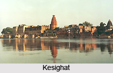
Ghats of Mathura
 Ghats of Mathura are the sacred spots of Hindus. Mathura is considered as the sacred place for the devotees of Lord Krishna. It is the birthplace of Lord Krishna. Some of the sacred ghats like Vishram Ghat, Brahmand Ghat, Somatirth Ghat, Koti Ghat, Chakrathirth Ghat, Somatirth Ghat Vignaraja Ghat, Dashashwamedh Ghat, Saraswati Sangam Ghat, Samyamana Ghat, Dharapatanaka Ghat, Navtirtha Ghat, Naga tirth ghat and many more ghats were built by the different rulers or social workers of Mathura, Uttar Pradesh.
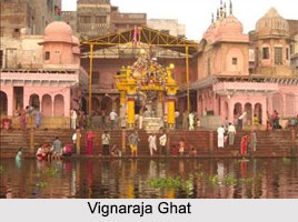
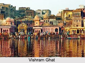
Vishram Ghat
Vishram Ghat is located in Mathura city of Uttar Pradesh. It is regarded as the most significant among the 25 ghats of the city. Vishram Ghat is believed that the traditional Parikrama of Brij Bhoomi begins and ends at this ghat.
Brahmand Ghat
Brahmand Ghat is located just a few meters ahead of Raman Reti and Nand Bhawan, along the banks of the Yamuna River. It is considered a sacred place among the Hindus due to some mythological importance.
Vignaraja Ghat
Vignaraja Ghat is also called Ganesha Ghat or Senapati Ghat. It is believed that if one takes bath in this ghat, Vignaraja will remove all the obstacles from one"s path of devotional service.
Dashashwamedh Ghat
Adi Varaha Purana mentioned that, one who bathes in Dashashwamedh Ghat will enjoy the pleasures of heaven. In the past, Asvamedha Yajna (horse sacrifice) was done here for glorifying Lord Krishna.
Saraswati Sangam Ghat
The rivers Yamuna and Saraswati meet at Saraswati Sangam Ghat. One who bathes in this tirtha will receive the qualities of a sannyasi. There is a small Vamana temple next to the bridge which crosses the stream.
Brahma Ghat
According to the Hindu mythology, Lord Brahma did austerities at Brahma Ghat for nearly 1,000 years. It is believed that by taking bath at this Ghat, one will go to Vishnu Loka.
Somatirth Ghat
 Somatirth Ghat is dedicated to the Hindu Moon God. If one bathes at this tirtha, one gets the happiness of living on Soma loka. This place is known as Krishna Ganga Ghat. It is called so because Lord Krishna manifested Ganges in this place. The river Ganges and Yamuna meet at this place.
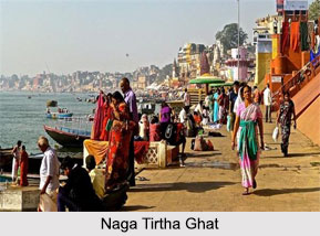
Naga Tirtha Ghat
Naga tirth ghat is the best of all tirthas. By taking bath here, one can attain heaven and by dying here one is freed from rebirth.
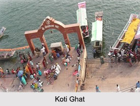
Koti Ghat
If a person takes bath at Koti Ghat and offers charity, he will be worshiped in Vishnu Loka. It is said in the Vishnu Purana that he will get the benefits of bathing in koti (million) tirthas i.e., bathing in million holy ghats and rivers and giving charity of koti cows. If one performs shraddha at this place, all his ancestors will be liberated from the sins.
Tourism in Mathura District
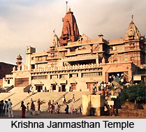
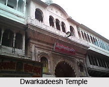
Mathura District abounds in place of religious and historic interest. All round the year, a large number of religious festival and fairs are held in Matura District and adjoining areas of Vrindavan Gokul, Brazen and Goverdhan Mountain. With the birth place of Lord Krishna, there are many tourist attraction sites like Jama Masjid, Dwarkadheesh Temple, Mathura Museum and Vishram Ghat.


