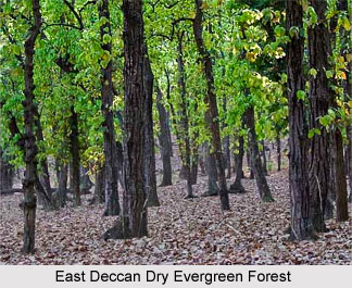
 Forests in Southern India speak in volume about the remnants of the southern forest topography, terrain, climate, vegetation portraying the natural diversity. East Deccan Dry Evergreen Forests in India Extending as a narrow strip along the southern coastal areas of Andhra Pradesh and Tamil Nadu states in India, the vegetation in the East Deccan dry evergreen forests have an unusual physiognomy that makes it distinctive from most of the other dry forests. These forests have the ability to stay green during the long dry season, unlike the other dry forests of the Indo-Pacific region that lose their leaves for part of the year. The forests cover a total area of 25,500 square kilometres and extend from the Ramanathapuram District of Tamil Nadu to Nellore District of Andhra Pradesh. The forests have Gondwanaland origins and the average rainfall in these forests is 800 mm. The forests receive most of the rainfall during the brief northeast monsoon that occurs between the months of October and December. The maximum temperatures in these forests during the long dry season can reach a stifling 44A§C. The original vegetation in the East Deccan dry evergreen forests in India had emergent species of deciduous elements like Albizzia amara and Chloroxylon spp. However, the original canopy-forming deciduous species have deceased due to human pressures, and the shrubby evergreen species now form a closed evergreen under story. Hence, the existing vegetation type in the forests represents a low forest (up to 10 m) with a complete, closed canopy. The canopy is mostly consisting of small leathery-leaved evergreen trees with short trunks and spreading crowns. Though the forests also harbour a large number of climbers, the bamboos are completely absent.
The South Deccan Plateau dry deciduous forests in India are located adjacent to the moist deciduous forests that lie along the foothills of the southern extent of the Western Ghats Mountains. Though the forests are not exceptionally rich in biological diversity or endemism, they are home to numerous flora and fauna species. The forests are included in those three eco regions through which two of India`s most important Elephant conservation areas, the Nilgiris- Eastern Ghats and the Anamalais-Nelliampathis; and two of the most important TCUs extend across.
South Deccan Plateau dry Deciduous Forests in India form an eco region that represents a large area of tall, tropical dry forests in the southern Deccan Plateau, on the leeward side of the Western Ghats Mountain Range. The eco region extends across the southern Indian states of Karnataka and Tamil Nadu and covers the southern portion of Karnataka`s Malnad region, extending south into the Kongu Nadu region of eastern Tamil Nadu. It has its links to the ancient, southern circumpolar continent, Gondwanaland. Climate plays an important role and influences the natural vegetation in these forests. The tall Western Ghats Mountain Range intercepts the moisture in these forests from the southwest monsoon and as a result, the eastern slopes and the Deccan Plateau receive very little rainfall. The annual rainfall in these forests ranges from 900 to 1,500 mm and the rainfall is mainly caused by the southwest monsoon, during the months of June to September.
The South Deccan Plateau dry deciduous forests in India are flanked by the moist deciduous forests along the lower elevations and foothills of the Western Ghats to the west. They are flanked by the thorn scrub to the east. In 1968, the forests were classified by Champion and Seth as Southern Dry Mixed Deciduous Forests, where Teak is not conspicuous. The thorny plants have become more common in some areas in the forests, where grazing pressure is high. The forests have a three-storied structure, with an upper canopy of 15-25 m, an under story of 10-15 m, and undergrowth of 3-5 m. The Lianas drape the trees in denser, mature forests.
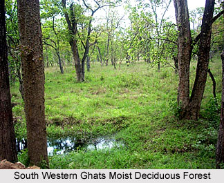 South Western Ghats Moist Deciduous Forests in India lie adjacent to the montane rain forest eco-region in the southern extent of the Western Ghats Mountain Range, the South Western Ghats moist deciduous forests in India create a wonderful landscape. The landscape extends from the lowlands to the highest peaks of one of the richest and most diverse ecosystems of the bioregion. The forests are located between 250 and 1000 meters elevation and they create an eco-region that is wider in the drier, leeward side of the mountain range. Covering an area of 23,800 square kilometres, the eco-region drops down to the dry Deccan Plateau, in this side, to encompass some prime habitat. Some of the most important populations of Tiger, Asian elephant, and Gaur live in these forests. The forests also represent a transition area between the South Western Ghats Montane Rain Forests and the South Deccan Plateau Dry Deciduous Forests. They include species from both types of forests, as well. For this reason, the species richness in these forests is high.
The South Western Ghats moist deciduous forests in India provide continuity of ecological processes between the lowland and Montane ecosystems. The moister forests support many of the larger vertebrates that are also found in the dry forest eco region but at higher densities. These forests surround the montane evergreen rain forests in the southern part of the Western Ghats Mountains. They extend across the southern Indian states of Kerala and Tamil Nadu and as they are a part of the Deccan Plateau, they have Gondwanaland origins. The swath of the moist deciduous forests is very narrow on the steeper, windward side of the mountain range. The southwest monsoon rains promote a wet evergreen forest in this side. However, the drier conditions caused by the rain shadow, result in a broader, uneven swath of moist deciduous forests, on the shallower leeward side. These forests extend further, into the Deccan Plateau. The complex landform influences rainfall on the leeward side and some of the areas can receive less than a fifth of the 3,000 mm or more of annual rainfall that is deposited higher in the mountains.
Covering the southern portion of the Western Ghats range in Kerala and Tamil Nadu, the South Western Ghats montane rain forests are an eco-region of southern India. The forests are situated at elevations over 1000 meters and are cooler and wetter than the lower-elevation South Western Ghats moist deciduous forests that surround the montane rain forests. The forests are considered to be the most species-rich in the peninsular India, and are home to in numerous endemic species. The total area of the eco region is 22,600 square kilometers and it is estimated that only 3,200 square kilometers, or 15% of the intact area, is protected.
 The annual rainfall in the South Western Ghats montane rain forests in India exceeds 2,800 mm. The rainfall is caused by the northeast monsoon during the months of October to November and the southwest monsoon causes rainfall in the forests during the months of June to September. The forests are also considered as the wettest portion of peninsular India. The forests are home to a rich variety of plant species, because of having a cool and moist climate, high rainfall, and variety of microclimates brought about by differences in elevation and exposure. About 35% of the plant species are endemic to the eco-region and the forests support a great diversity of species. The trees in these forests generally form a canopy at 15 to 20 m, and the multi-storeyed forests are rich in epiphytes, especially orchids.
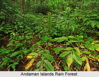
The Andaman Islands rain forests are one of the best ones among all the eco-regions in India. The Islands are located between the Bay of Bengal and the Andaman Sea, and they are affiliated with both the countries like India and Myanmar, in important ways. The Andaman Islands rain forests are relatively intact and are quite similar to the other rain forests in India. The tall and major timber trees like gurjun dominate the hill forests in this wet climate and the southern islands are more favourable to a different type of dipterocarp. The monsoon areas in the Andaman Islands are characterised by shade trees called padauk and the Terminalia genus of trees.
The Andaman Islands rain forests are located in the eastern Indian Ocean, as part of the Bay of Bengal. The climate of the forests is warm tropical, and the temperatures range from 22 to 30 degrees Celsius. The average annual rainfall in the forests ranges from 3,000-3,800 millimetres and the rainfall is heavily influenced by monsoons. Monsoons usually come in the Andaman Islands rain forests, from the southwest (May to September) and from the northeast (October to December). The forests are geographically part of the long island arch that runs from Arakan Yoma in Myanmar to the Mentawai Islands off Sumatra.
Forests in Southern India
Forests in Southern India is enriched with the hues of numerous types of forestry.


