Introduction
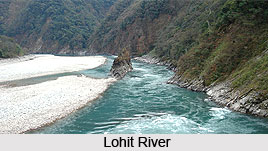
Anjaw district in Arunachal Pradesh was created on 16 February 2004 under the Arunachal Pradesh Re-organization of Districts Amendment Bill. It is located on the banks of the Lohit River, a tributary of the Brahmaputra River. It is the easternmost district. It is a wildlife rich district. Mammals such as Mishmi takin, Red goral, Gongshan muntjac, Leaf muntjac occurs while among birds there is the rare Sclater`s Monal. A specific pine called Pinus merkusii is found only in Anjaw district in the entire northeastern India. A flying squirrel has also its range in this district.
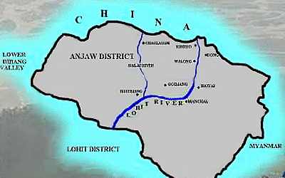
Anjaw district has seven administrative Units: Hayuliang, Hawai, Manchal, Goiliang, Walong, Kibithoo and Chaglogam. The main tribes of this district are Mishmi and the Zakhring. The main rivers of this district are: Lohit River, Lam River, Tidding River, Dalai River, Krowti River, Dichu River, Lati River, Klung River, Dav River, Telua River, Ampani River and Sarti River. The main crops cultivated in this district are maize, millet, rice, beans, cardamom, orange, pears, plum, and apple.
History of Anjaw District
History of Anjaw district can be traced back to 1914. During this time North East Frontier Tract was formed by the British Administration to control three areas viz. the Western Section, the Lakhimpur Frontier Tract and the Central and Eastern Section. In each section, a political officer was stationed for looking after the tract. In the year 1919, reorganization of the western section took place and it was renamed as Balipara Frontier Tract whereas the Central and Eastern Section was renamed as Sadiya Frontier Tract. Sadiya Frontier Tract also included the present Lohit district and the headquarters was located at Sadiya.
Later, after 24 years, the administrative set up of North East Frontier Tract transformed after the splitting of Tirap Frontier Tract from Lakhimpur Frontier Tract in the year 1943. Sadiya Frontier Tract then underwent bifurcation, leading to the formation of two districts namely Mishmi Hills district which comprised of the region inhabited by the Mishmi tribe and Abor Hills district which comprised of the areas inhabited by the Adi tribe.
Tezu was made the headquarters of Mishmi Hills district on 13th of August 1952. Hayuliang became the headquarters of Assistant Political Officer that started functioning in the year 1953. In 1954 Mishmi Hills district acquired a new name as Lohit Frontier Division. Two years later, in 1956, Dibang Valley became a separate sub division and its headquarters was situated at Roing. Lohit Frontier Division was changed to Lohit district nine years later in the year 1965. However, Dibang Valley was carved out from Lohit district along with its headquarters at Anini in 1980 for administrative convenience.
Finally on 16th February 2004, Anjaw district was formed under the Arunachal Pradesh Re-organization of Districts Amendment Bill with its headquarters at Hawai.
Demography of Anjaw District
According to the Population Census in the year 2011, the Anjaw District had population of 21,089 of which male and female were 11,686 and 9,403 respectively. The population of Anjaw District constituted 1.53 percent of total population of Arunachal Pradesh. The population density of Anjaw district for 2011 is 3 people per sq. km. The Anjaw district administers 6,190 square kilometres of areas. The average literacy rate of Anjaw District is 59.40 percent. If things are looked out at gender wise, male and female literacy were 69.54 percent and 46.39 percent respectively. The total literate in Anjaw District were 10,514 of which male and female were 6,920 and 3,594 respectively.

People of Anjaw District
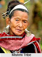
People of Anjaw district mainly comprise of the Mishmis and the Meyors. Distinct and unique culture and lifestyle distinguish these tribes. Both have their own set of spiritual beliefs, occupations and festivals. In spite of cultural differences, both the tribes believe in maintaining a peaceful relationship with each other.
Religion of Mishmi Tribe
People belonging to the Mishmi tribe of Anjaw district are highly spiritual. They are mainly animist and their characters reflect both benevolence and maliciousness. Jabmalu or Matai is considered to be the supreme spiritual being of this tribe. Next position is assigned to Ringya or Amik and is often addressed along with Jabmalu. The name Ringya is given by Tawrahs and Amik by Kamans. Tawrahs and Kamans are the sub categories of Mishmi tribe. According to the beliefs of Mishmi tribe, Jabmalu is regarded as the Supreme Creator who controls the human affairs whereas Ringya or Amik is the Sun Goddess and is considered to be the Goddess of Truth and Justice. In times of seeking the truth, the name of this Goddess is constantly chanted. The next rank is assigned to several spiritual beings including Thechaya or lumbok, Duyuya or Suto, Kesha Kanang or Khinim Drang, Buru or Buruya, Hutung or Dappa and many other spirits who are remembered during different occasions.
Administration of Mishmi Tribe
The traditional village council of this tribe is known as Kabeya to the Tawrahs and Pharai to the Kamans. Gaonbura are the Government representatives of the villages. Mishmis are basically a small clan and in the proceedings of village council, affected parties and neutral members also participate. Generally the decision of the council is followed by all the parties. It is a common belief that the innocent would remain unaffected by any harsh treatment and thus in case of serious allegations people pour molten iron or boiling water on the alleged person to test his innocence. This act is called Pasai by the Tawrahs and Mashai by the Kamans. During such events, the decision arrived is previously sanctioned socially.
Art of Mishmi Tribe
People of this tribe are excellent weavers and master the art of handicraft making. Beautiful jackets and colourful skirts adorned with impressive designs are made by the women of the tribe whereas men are involved in a variety of cane and bamboo crafts.

People of Meyor Tribe
Meyor is a small tribe constituting a small population that dwell in Kibithoo and Walong circles of the district. Meyors are also animists like the Mishmis but they have also adopted Mahayana Buddhism. The region inhabited by Meyors houses a few Gonpas which also includes the first Gonpa constructed 1960 at Kaho village that testify this fact. Meyor villages are about fifteen in number which are situated on either side of the Lohit River that flows through Anjaw district. Cultivation is the most common occupation of these people; however, lately many of them have also taken up Government jobs and business activities. People of this tribe are hard-working and peace loving and live in harmony with the people of Mishmi tribe.
Festivals of Meyor Tribe
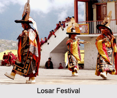
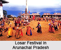
Several festivals are celebrated by the Meyors among which Losar is the most prominent one. Other festivals include Sungkhu, Tso Tangpo and Tsotangpho Wangley. In the month of August-September, Sungkhu is celebrated which marks the harvest of new food grains. The first harvest is offered to God Yodak by the people. Tso Tangpo is observed in the month of April every year. It is a spring festival.
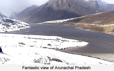
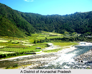
Tourism in Anjaw District
Tourism in Anjaw district offers an amazing experience especially to the nature lovers. The mesmerizing natural beauty of the place is enhanced by the pleasing climate of the district. The district not only has a picturesque landscape but also holds historical significance. A number of adventurous activities are also conducted here which attracts numerous tourists from distant places. The district is widely inhabited by several tribes and exploring the culture and lifestyle of these tribes also forms a significant aspect of tourism in Anjaw district.
Hayuliang
Hayuliang is located at about 100 kilometres away from Tezu which is the headquarters of Lohit district. As per the Mishmi dialect, the word Hayuliang implies `the place of my liquor`. Hayuliang is the Sub-Divisional Headquarter. Hayuliang is located at an altitude of 750 meters level above Mean Sea Level; Hayuliang enjoys a pleasant, cool and salubrious climate. The beautiful panoramic view of the confluence of Dalai River and Lohit River and scenic surrounding make the place worth visiting.
Hawai
Hawai is the young District Headquarter of Anjaw District. It is located on the left of the Lohit River at about 58 kilometres from the South-East of Hayuliang by road. "Hawai" in Kaman Mishmi dialect means "Pond". This beautiful township is situated at an altitude of 1296 Mt. above sea level. A Cable Suspension Bridge, named as Anjaw, over the mighty Lohit River, connects it. Its pleasant climate, scenic landscape and unique ethnic culture make it one of the best places for visits.

Chaglogam
Chaglogam is another beautiful tourist destination situated on the left bank of Dalai River. Located at an altitude of 1258 metres above sea level, the place is ideal for adventure lovers. Chaglogam offers wondrous experience of mountaineering, trekking, rafting and angling. It is also extremely appeasing to the nature lovers as the place has a magnificent natural beauty.
Walong
Walong is situated at an altitude of about 1094 meters. It is located 200 kilometres from Tezu, Walong is a Circle Headquarter with a tremendous tourism potential. The word "Walong" in Mishmi dialect means "a place with full of bamboos." This place is historically prominent because of it being the scene of gallant fight by Indian Soldiers and invading Chinese forces in 1962 and endowed with spectacular landscapes, Walong is a popular tourist destination in the district. Namti Valley, commonly called as Namti Maidan, is placed above 7 kilometers from Walong on the way to Kibithoo. The fiercest Sino - India battle of 1962 was fought in this valley. The beautiful age-old pines standing in witness of the supreme sacrifice made by the brave Indian Soldiers defending the borders of sacrifice renders Namti Maidan a special tourist spot. To commemorate the exemplary sacrifice of the brave soldiers of Indian Army, a beautiful War Memorial has been built at Walong. The climate is cool and salubrious. A hot spring beside the Lohit at a distance of four Kilometers from Walong is another attraction for all kinds of visitors. Besides Walong, there is another hot spring located at a distance of 39 kilometres from the confluence of the Lohit River and the Dichu River. It is 64 kilometres towards East from Kibithoo. The region is endowed with spectacular landscapes of picturesque plateaus and valleys and snow-clad hills.
Dong
Dong is located on the left of Lohit River, Dong is a small but beautiful village of Meyor Communities. Majestic snow-capped mountains and picturesque pine forests surround it, the village welcomes earliest sunrise in the country. It is situated at a distance of seven kilometres from Walong, it is connected by a nice foot suspension bridge over the Lohit River. This village is also one of the places where the earliest sunrise can be witnessed.
Kibithoo
Kibithoo is a small but beautiful Circle Headquarter located close to the Indo-China Border at an altitude of about 1305 Mt. above sea level. It is nestled on the right bank of the mighty Lohit; it is 140 kilometres away to the North of Hayuliang. Flowers of vivid hues, cascading waterfalls, wild raspberries and spectacular pine forest adorn the place in most exquisite way. Tall and blue mountains standing in a pleasantly cool climate adds to the charm of Kibithoo. In past times, the place has also been the witness of the war between India and China in the year 1962.
The whispering pine forests, wild rash berries, beautiful flowers and majestic waterfalls from the surrounding hills set against tall blue hills add grandeur to it. Its climate is cool and salubrious. The place also witnessed some of the severest fights by Indian Soldiers against the Chinese in 1962. Kibithoo Township is endowed with recently commissioned 30 KiloWatt Micro-Hydel Electricity Project.