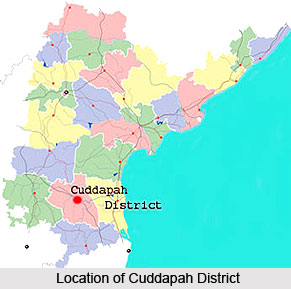
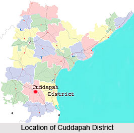
 Cuddapah is one of the 23 districts of Andhra Pradesh and has been named after the city of Kadapa which is also the district headquarters. The Cuddapah district is part of the Rayalseema region. The district has further been subdivided into 51 mandals. The district is located towards the south central part of Andhra Pradesh and lies 8 kilometers to the south of the Penna River.
Cuddapah District
Cuddapah district is located in the south-central part of Andhra Pradesh and is included in the Rayalseema region.
Introduction
Cuddapah is one of the 23 districts of Andhra Pradesh and has been named after the city of Kadapa which is also the district headquarters. The Cuddapah district is part of the Rayalseema region. The district has further been subdivided into 51 mandals. The district is located towards the south central part of Andhra Pradesh and lies 8 kilometers to the south of the Penna River.History of Cuddapah District
 Cuddapah district in Andhra Pradesh is a territory endowed with a rich history. Also known as Kadapa, its history dates back to the second century BC, and begins with the Maurya Empire and Satavahana dynasty as per the evidences of Archaeological survey. It has been the battle-ground for many dynasties such as the Pallava dynasty, Chalukya dynasty and Chola dynasty, which waged wars for establishing a stronghold over South India.
The kings of the Pallava dynasty were able to gain authority when they penetrated into the North of Cuddapah district. They ruled for a certain period during the 5th century. Later on the Cholas defeated the Pallavas and their rule appears to have lasted till the later part of the 8th century. Subsequently the next dynasty which established its authority for a considerable period is said to be that of Banas. With the retreat of the Banas, Cuddapah came under the sway of a dynasty of kings belonging to the Rashtrakuta dynasty. Popular rulers during this time were King Indra III (915 A.D.) a later king Krishna III. With the death of king Krishna III, the power and influence of this dynasty declined. The Telugu Cholas, who were the feudatories of the Chola dynasty, ruled entire Cuddapah District and their power seems to have suffered a temporary eclipse due to the aggression of Pandas but soon, the Chola kingdom firmly established once again in the district during the first half of the 13th century.
In the latter half of 13th century, the district fell into the hands of Ambadeva who had temporarily usurped the Kakatiya crown and ruled from Vallur, 15 Kms from Cuddapah. During this time a land survey was carried out and a river channel was constructed at Lebaka. Subsequently Kakatiya King Prataparudra succeeded to the throne after the death of Ambadeva and ruled the district with Warrangal as the Capital during the opening of 14th century.
In 1309 AD came the invasion of the Deccan by Muslims during the reign of Khilji emperor Ala-Ud-din Khilji and Pratapa Rudra was defeated and he was carried as a prisoner to Delhi. Warrangal, the capital, now came into the hands of Ala-ud-din. In 1336 AD the Vijayanagar Empire was found by Hari Hara and Bukka.
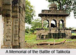 During 1344 AD a Hindu confederation of Warrangal, Krishna Vijaya Nagaram Raja and the Hoysala King of Mysore, drove the Muslims out of Warrangal and rolled back the tide of their advance. In the battle of Talikota, the Hindus and Muslims with forces of almost fabulous strength, contested for the supremacy over Deccan. The outcome of this war was that the Hindus were totally defeated and the Deccan fallen into the hands of King of Golconda.
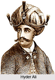
In the year 1740 AD the Marathas invaded and defeated the Nawab of Kurnool and Cuddapah. Hyder Ali obtained the possession of Gurramkonda and Cuddapah from the hands of Marathas and appointed his brother-in-law Mir Saheb in Cuddapah district. Hence Mir Saheb and his son Kamaluddin were the first rulers of the district. The district later fell in to the Nizam by the treaties of Mysore and Srirangapatnam.
Later on this area was ceded to the British by the Nizam and Cuddapah got a taste of the lawlessness of the `palegars`. Finally Major Munro, the first District Collector took over the reins of administration. He gave peace to the people of this region.
Geography of Cuddapah District
 Geographically, Cuddapah district is situated within 13.43` and 15.14` of the northern latitude and 77.55` & 79.29` of the eastern longitude. The district spreads northwards beneath the Western slopes of the Eastern Ghats mountain range as a rough parallelogram, dented deeply in its Southern, Western and Northern boundaries. It is surrounded by Kurnool district on the North, Chittoor district on the South, Nellore district and Prakasm district on the East and Anantpur District on the West. The total geographical area of the Kadala district is 15,379 sq. Kms. Cuddapah district is said to be the heart of the Rayalaseema as it is centrally located and well connected with the 4 districts of Rayalaseema. The climate of Kadapa district, as it is also known, is such that it experiences its minimum temperature, in November-January, at about 28-30 C. The hottest temperature ranges between the 40-45 ranges during April-May. Based on the Agro-climatic conditions the District falls both in Southern and scarce rainfall zone. Kadapa is one of the districts in Rayalaseema area, with an uneven, isolated rainfall in different parts of the district and with large dry tracts. The District`s normal rainfall is 700 mm and its actual rainfall varies from 400+ to 800+ mm. It gets its major portion of rainfall (around 60%) during June-September period through South-West Monsoon. More than 30% of its average rainfall comes from North-East Monsoon during October-December. It gets its remaining 10-15% of its rainfall during Winter Period (January-February) and in Hot Weather Period (March-May).
The soil of the district has been classified into red ferruginous soil and black soil. These two classes can be sub divided into clay, loam sand with finer distinctions. They range from poor to fertile. Red soils occupy 53% of the cultivated area and are mostly situated in L. R. Palli, Rayachoty, Rajampet, Pulivendla and Kodur Mandals. These soils have a low nutrient status. Black soils covered nearly 47% of the cultivated area and are generally associated with clay content located in Muddanur, Jammalamadugu, Proddatur, Mydukur, Pulivendla and Kamalapuram Mandals.
The district is blessed with a series of beautiful valleys through which holy rivers like Pinakini (Pennar), Papaghni, Chitravathi, Mandavya, Cheyyeru cut across the district. The river Pennar is the most important river flowing right through the District whose legend is incorporated in a sasanam (inscription) at Gandikota. The Seshachalam range of hills passes through this district and is ultimately crowned with the Holy shrine of Tirumala in the Chittoor district.
The forests of the district are of a dry deciduous type. Its most important species is the famous pterocaropus santalinus or red sanders. Since this is the only district of the country in which this species occurs, a positive conservation to extend them has been evolved. These forests fall under three zones wise those of Teral or Fuel Forests upto an elevation of hundred feet, Hill Forests or Red Sanders lying between the elevation of 800 and 2000 feet and Shoreaeugenla occupying elevations above 2000 feet.
The major agricultural crops grown in the region are Paddy, Groundnut, Red gram, cotton and Bengal Gram. Among the fruit crops grown here, the major ones are Mango, Citrus, Banana, Melons and Papaya. Turmeric, Onion, Chillies, Coriander, Vegetables and Chrysanthemum are other commercial crops grown in the district. The major irrigation sources in the district that provide water to the agricultural produce are K-C canal, the Mydukur and the Chapadu Project, the upper Sagileru and lower Sagileru and the Pincha Projects.
The district of Cuddapah is rich in minerals. The major minerals in the district are Berytis, limestone and asbestos. The high grade asbestos of Chrysotile variety, Berytis and limestone suitable for manufacture of cement are present in the district in large quantities. It also possesses important deposits of white clay, small deposits of small iron ore, ochre and steatite and abounds in construction material. Apart from Major Minerals, Minor Minerals are Napa Slabs, Road Metal, Building Stone, Marble, Mosaic Chips and Rehmatti are also in the District. There are extensive outcrops of limestones, Dolomites, Granite and Quartzites in major parts of the district, which could be utilised as building material.
Demography of Cuddapah
The rural population of the district is as high as 1972.99 and the urban population are 600.48. The density of population in the district is 168 persons per square kilometer. The total literacy rate of Cuddapah is 64.02 percent. Among the literate population 76.98 percent of the males are literate and 50.76 percent of the females have attained the mark of literacy. The work force of Cuddapah district is equal to 43.95 percent.
Culture of Cuddapah
 Cuddapah district is well known for its composite culture. Generally the people of the Cuddapah district are very hard working and hospitable in nature. The principal religion that is followed by the people Cuddapah is Hinduism. The other religions which are followed in the district are Islam, Jainism and Buddhism. It is said that due to the various religious as well as regional influences the district of Cuddapah has acquired its composite culture. Altogether it can be said that Cuddapah has a rich cultural heritage.
Temples of Cuddapah District
 Cuddapah district primarily can be said to be an agricultural and industrial region, laying stress on the metropolitan future. The district thrives on admired tourist attractions, forests, forts and of course religious institutions. Mosques, Buddhist architecture and Hindu temples dominate the structural map of Cuddapah. Some of the numero uno are- Chennakesava Swamy Temple, Siddheswaraswamy Temple, Vrushabha Chaleswara Swamy Temple, Eswari Devi Temple, Sudarshana Chakra Temple, Pushpagiri Temple Complex and Veeranjaneya Swamy Temple. Almost all of these temples mentioned are consecrated to the chief gods/goddesses of Hindu mythology, like Vishnu, Shiva, Parvati or Hanuman. The temples of Cuddapah District are reminiscent of ancient architectural style, dating back to as old as the times of Mahabharata and Ramayana. Jain shrines dating back to the 14th century are considered extremely sacred to the pilgrims, located in Danavulpadu in Cuddapah district. Medieval caves enshrining local gods/goddesses are also visible, dotted around the rocky terrain of the district. Cuddapah is also known as `Kadapa` nowadays, because it is regarded to be the gateway to the sacred hill-Pagoda of Shri Venkateshwara of the iconic Tirupati. Historians describe Cuddapah as a handsome place, lined with exquisite temples-bearing lofty gopurams, floral motifs on temple walls, scenes depicted from epics and of course elaborately engraved pillars.
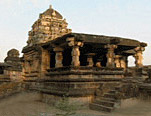
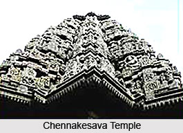
Chennakesavaswamy Aalayam Temple
The Channakesava temple forms an integral part of Pushpagiri temple with mini-shrines and a two-storied tower over the gate. It was built by a Chola king and has the Vesara type of architecture. The idol is six feet in height.
Monuments In Cuddapah District
Historical Monuments In Cuddapah District
 Places of historical interest in the Cuddapah district are found in the form of beautiful forts. These places of historical interest are listed below.
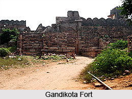
Gandikota Fort
Gandikota is situated on the banks of the Pennar River. It derives its name from two Telegu words- `Gandi` meaning gorge and `Kota` meaning fort. Also known as George fort, it is a stone fort built upon a hill. Guarded by a huge entrance, almost 20 feet high and `0` bastions each over 40 feet high, it still remains a rather imposing structure. The fort is believed to have been built during the later half of the 13th century AD. There are a number of places of interest within the fort which are worth seeing. The Ranganatha and Madhavaswamy temples, built during the 15th and 16th centuries, are adorned with sculptures and built in an architectural style reminiscent of the Vijayanagara period. The Juma Masjid covers a huge area stands next to a large granary, used to stockpile food during the time of a siege. An impressive Pigeon Tower and a palace with plastered decorations are also interesting structures. From the top of the tower a panoramic view of the surrounding forests and valleys can be obtained. Located nearby is the Mylavaram Dam which is a popular picnic spot because of the sparkling waters, lush trees and pleasant environment. Gandikota is located 77 Kms from Cuddapah district.
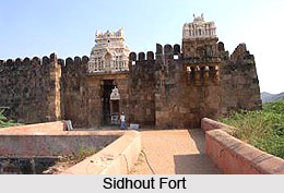
Sidhout Fort
Another major spot of tourist interest of the Cuddapah district is the Sidhout fort. It stands on the banks of the Pennar River and covers an area of 30 acres. It was built in 1303 AD. The majestic gateways at the two ends have embellished pillars and intricate carvings of Gajalakshmi at the top. 17 square bastions which protected the area are still an impressive sight. A special feature of the fort is an ancillary passage allowing people to enter when the main gates are closed. Often referred to as the gateway to Srisailam or Dakshina Kasi, Sidhout Fort also encompasses beautifully sculpted temples inside its premises.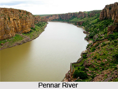 These included Siddheswara, Bala Brahma, Ranganayaka Swamy and a Durga Temple that attracts numerous pilgrims. The Sidhout Fort is located near Siddhavatam, around 25 Kms from Cuddapah.
Tallapaka
Tallapaka village is the birthplace of one of the most famous personalities of Andhra Pradesh, Vaggeyakara Annamacharya. He was a great religious poet. Born in 1424 at Tallapaka Village in Rajampet Mandal, he favoured the lyrical style of poetry and composed songs and psalms. On Lord Venkateswara of Tirumala, his family deity he composed more than Thirty two thousand devotional hymns - Sankeerthanas. These keerthanas were set to Carnatic music and are very popular throughout India. Annamacharya`s wife Timmakka is the first poetess in Telugu literature. She composed Subhadrakalyanam. The sons and grand children of Annamacharya were all born poets who continued their writings in the footsteps of Annamacharya. Cuddapah district`s name is glorified by the efforts of the `Tallapaka Poets.` Chennakesava, Siddeswara temples, Srichakra, Eka, Tatayya idol and TTD dhyanamandir are the main attractions to the tourists. Annamacharya had established a Hundi at Tirumala and enriched the temple.
Tallapakka is located 55 Kms from Cuddapah & 6 Kms from Rajampet on Cuddapah-Chennai highway.
Religious Monuments In Cuddapah District
 There are a number of places of religious interest in Cuddapah district of Andhra Pradesh. A few of the most important ones are discussed below.
Attirula
Attirala is a very sacred place, located on the east bank of the river Cheyyeru. The sanctity of the river Cheyyeru was elaborately described in the great epic of Mahabharata. It is believed that the river Cheyyeru redeemed Parasurama from the sin of matricide and also miraculously gave hands to Likhita, the brother of Sankha a great sage. It is a centre of Vedic culture and famous for its scenic beauty. The temple of Parasurama Kshetra is located here. To the south of this temple there is a 72 pillared hall and on the eastern side there are two famous temples on the hill slope dedicated to Gadhadara and Thretheswara.
Parasurama Kshetra is worth seeing for its sculptural beauty and grand appearance. There is a Jyothistambha, higher up in the temple of Thretheswara, on the top of a hill. Jyothi, lighted on festivals, is visible to distance of 30 Kms around. Attirula is located 8 Kms from Rajampet and 55 Kms from Cuddapah.
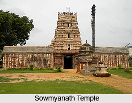
Nandalur
Nandalur is on the west bank of river Cheyyeru. Located here is a very big temple, the Sowmyanath Temple occupying nearly ten acres. It is a replica of Thiruvannamalai and was patronized by the rulers of the Chola dynasty, Pandya dynasty and Kakatiya dynasty, Vijayanagara, Pottapi and Matli Kings. Most of the inscriptions found here are in Tamil. Lord Sowmyanatha is installed here on an elevated platform. Nandalur was once a famous Buddhist centre in Rayalaseema. In 1913 Buddhist caves and viharas were discovered. These are well worth a visit. Nandalur is located on the Cuddapah-Chennai highway and is at a distance of 38 Kms from Cuddapah.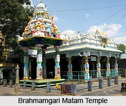
Pushpagiri
Pushpagiri is well known for its numerous temples. The Vaishnavas call it Madhya Abhiloma and the Saivas call it Madhya Kailasam. Pushpagiri is known as the second Hampi. It is one of the important Advaitha Mutts established by Sankaracharya and is the only place in Andhra Pradesh where the holy Peetham of Sankaracharya is located. The largest and best known among temples is the Chennakesava Temple, which according to the earliest inscriptions found in the temple complex, dates back to 1298 A.D. The dancing Ganapati and Lord Krishna preaching the Bhagavad Gita to Arjuna are remarkable pieces of Art. The annual temple festival is conducted for 10 days in March-April. Other temples of interest here include Trikuteswara, Durga, Shiva, Rudrapada and Devi, which are remarkable for their architectural precision and excellent images. Pushpagiri is on the banks of Pennar (Pinakini) 16 Kms from Cuddapah City.
Gandi
The temple of Anjaneya Swamy here is built on the foot of a hill on the western side of the river Papaghni in the midst of picturesque surroundings. It has gained great name and fame as a Vayu Kshethra. Legend has it that Lord Rama visited this place on his way back from Lanka. In order to welcome him, Vayu, the father of Anjaneya, hung a wreath of golden flowers across the ravine. Before leaving this place, Rama carved the figure of Anjaneya on a rock. The stone praakaaram around the sanctum sanctorum is said to have been built by one Tirupathi Seshanna in 1911. Devotees come from very far to visit this temple in the month of Sravana. Gandi is situated 55 Kms from Cuddapah city and 8 Km from Vempalli on the Vempalli-Rayachoty route.
Vontimitta
 Vontimitta is famous for the Kodanda Ramaswamy Temple, which was built by the Chola and Vijayanagara kings. The images of Rama, Lakshman and Sita are carved on a single piece of rock. According to the legend, Rama, Lakshmana and Sita spent some time here in the forest during the period of their exile. Once to quench the thirst of Sita, Rama shot an arrow deep into the earth, upon which sweet water gushed out. Later, with this perennial water spring, two small tanks named Ramathirtham and Lakshmanathirtham were formed. Splendid architecturally, it boasts of a towering gateway, a large beautiful sculptured Mandapam with exquisitely carved pillars, an inner chamber and the sanctum. Few temples in the country can rival it for the sheer magnificence and beauty of its intricate carvings and finesse. Apart from the gateway, the large and beautifully sculpted mandapam with 32 pillars called the Madhya Ranga Mandapam leading to the inner chamber and sanctum is of great architectural interest. Vontimitta is locates 25 Kms from Cuddapah city on the state highway leading to Tirupathi.
Brahmamgari Matham
Kandimallayapalli is the place where Sri Potuluri Veerabrahmam, who was famous for his predictions and foresight about the future of the world, stayed. Veerabrahmam is the only futurologist that the East has produced. He entered Jeeva Samadhi in the year 1693. Brahmamgari Matham was built in Kandimallayapalli after his death. The walls are covered with the preaching and predictions of Veerabrahmam. A number of places of tourist interest are located in and around Matham. These include the Siddaiah Jeeva Samadhi, Eswaramma temple and the Poleramma temple. The Brahmamgari Matham is located 60 kms from Cuddapah on the Cuddapah - Porumamilla route.
Places of historical interest in the Cuddapah district are found in the form of beautiful forts. These places of historical interest are listed below.
Gandikota Fort
Gandikota is situated on the banks of the Pennar River. It derives its name from two Telegu words- `Gandi` meaning gorge and `Kota` meaning fort. Also known as George fort, it is a stone fort built upon a hill. Guarded by a huge entrance, almost 20 feet high and `0` bastions each over 40 feet high, it still remains a rather imposing structure. The fort is believed to have been built during the later half of the 13th century AD. There are a number of places of interest within the fort which are worth seeing. The Ranganatha and Madhavaswamy temples, built during the 15th and 16th centuries, are adorned with sculptures and built in an architectural style reminiscent of the Vijayanagara period. The Juma Masjid covers a huge area stands next to a large granary, used to stockpile food during the time of a siege. An impressive Pigeon Tower and a palace with plastered decorations are also interesting structures. From the top of the tower a panoramic view of the surrounding forests and valleys can be obtained. Located nearby is the Mylavaram Dam which is a popular picnic spot because of the sparkling waters, lush trees and pleasant environment. Gandikota is located 77 Kms from Cuddapah district.
Sidhout Fort
Another major spot of tourist interest of the Cuddapah district is the Sidhout fort. It stands on the banks of the Pennar River and covers an area of 30 acres. It was built in 1303 AD. The majestic gateways at the two ends have embellished pillars and intricate carvings of Gajalakshmi at the top. 17 square bastions which protected the area are still an impressive sight. A special feature of the fort is an ancillary passage allowing people to enter when the main gates are closed. Often referred to as the gateway to Srisailam or Dakshina Kasi, Sidhout Fort also encompasses beautifully sculpted temples inside its premises.
These included Siddheswara, Bala Brahma, Ranganayaka Swamy and a Durga Temple that attracts numerous pilgrims. The Sidhout Fort is located near Siddhavatam, around 25 Kms from Cuddapah.
Tallapaka
Tallapaka village is the birthplace of one of the most famous personalities of Andhra Pradesh, Vaggeyakara Annamacharya. He was a great religious poet. Born in 1424 at Tallapaka Village in Rajampet Mandal, he favoured the lyrical style of poetry and composed songs and psalms. On Lord Venkateswara of Tirumala, his family deity he composed more than Thirty two thousand devotional hymns - Sankeerthanas. These keerthanas were set to Carnatic music and are very popular throughout India. Annamacharya`s wife Timmakka is the first poetess in Telugu literature. She composed Subhadrakalyanam. The sons and grand children of Annamacharya were all born poets who continued their writings in the footsteps of Annamacharya. Cuddapah district`s name is glorified by the efforts of the `Tallapaka Poets.` Chennakesava, Siddeswara temples, Srichakra, Eka, Tatayya idol and TTD dhyanamandir are the main attractions to the tourists. Annamacharya had established a Hundi at Tirumala and enriched the temple.
Tallapakka is located 55 Kms from Cuddapah & 6 Kms from Rajampet on Cuddapah-Chennai highway.
Religious Monuments In Cuddapah District
There are a number of places of religious interest in Cuddapah district of Andhra Pradesh. A few of the most important ones are discussed below.
Attirula
Attirala is a very sacred place, located on the east bank of the river Cheyyeru. The sanctity of the river Cheyyeru was elaborately described in the great epic of Mahabharata. It is believed that the river Cheyyeru redeemed Parasurama from the sin of matricide and also miraculously gave hands to Likhita, the brother of Sankha a great sage. It is a centre of Vedic culture and famous for its scenic beauty. The temple of Parasurama Kshetra is located here. To the south of this temple there is a 72 pillared hall and on the eastern side there are two famous temples on the hill slope dedicated to Gadhadara and Thretheswara.
Parasurama Kshetra is worth seeing for its sculptural beauty and grand appearance. There is a Jyothistambha, higher up in the temple of Thretheswara, on the top of a hill. Jyothi, lighted on festivals, is visible to distance of 30 Kms around. Attirula is located 8 Kms from Rajampet and 55 Kms from Cuddapah.
Nandalur
Nandalur is on the west bank of river Cheyyeru. Located here is a very big temple, the Sowmyanath Temple occupying nearly ten acres. It is a replica of Thiruvannamalai and was patronized by the rulers of the Chola dynasty, Pandya dynasty and Kakatiya dynasty, Vijayanagara, Pottapi and Matli Kings. Most of the inscriptions found here are in Tamil. Lord Sowmyanatha is installed here on an elevated platform. Nandalur was once a famous Buddhist centre in Rayalaseema. In 1913 Buddhist caves and viharas were discovered. These are well worth a visit. Nandalur is located on the Cuddapah-Chennai highway and is at a distance of 38 Kms from Cuddapah.
Pushpagiri
Pushpagiri is well known for its numerous temples. The Vaishnavas call it Madhya Abhiloma and the Saivas call it Madhya Kailasam. Pushpagiri is known as the second Hampi. It is one of the important Advaitha Mutts established by Sankaracharya and is the only place in Andhra Pradesh where the holy Peetham of Sankaracharya is located. The largest and best known among temples is the Chennakesava Temple, which according to the earliest inscriptions found in the temple complex, dates back to 1298 A.D. The dancing Ganapati and Lord Krishna preaching the Bhagavad Gita to Arjuna are remarkable pieces of Art. The annual temple festival is conducted for 10 days in March-April. Other temples of interest here include Trikuteswara, Durga, Shiva, Rudrapada and Devi, which are remarkable for their architectural precision and excellent images. Pushpagiri is on the banks of Pennar (Pinakini) 16 Kms from Cuddapah City.
Gandi
The temple of Anjaneya Swamy here is built on the foot of a hill on the western side of the river Papaghni in the midst of picturesque surroundings. It has gained great name and fame as a Vayu Kshethra. Legend has it that Lord Rama visited this place on his way back from Lanka. In order to welcome him, Vayu, the father of Anjaneya, hung a wreath of golden flowers across the ravine. Before leaving this place, Rama carved the figure of Anjaneya on a rock. The stone praakaaram around the sanctum sanctorum is said to have been built by one Tirupathi Seshanna in 1911. Devotees come from very far to visit this temple in the month of Sravana. Gandi is situated 55 Kms from Cuddapah city and 8 Km from Vempalli on the Vempalli-Rayachoty route.
Vontimitta
Vontimitta is famous for the Kodanda Ramaswamy Temple, which was built by the Chola and Vijayanagara kings. The images of Rama, Lakshman and Sita are carved on a single piece of rock. According to the legend, Rama, Lakshmana and Sita spent some time here in the forest during the period of their exile. Once to quench the thirst of Sita, Rama shot an arrow deep into the earth, upon which sweet water gushed out. Later, with this perennial water spring, two small tanks named Ramathirtham and Lakshmanathirtham were formed. Splendid architecturally, it boasts of a towering gateway, a large beautiful sculptured Mandapam with exquisitely carved pillars, an inner chamber and the sanctum. Few temples in the country can rival it for the sheer magnificence and beauty of its intricate carvings and finesse. Apart from the gateway, the large and beautifully sculpted mandapam with 32 pillars called the Madhya Ranga Mandapam leading to the inner chamber and sanctum is of great architectural interest. Vontimitta is locates 25 Kms from Cuddapah city on the state highway leading to Tirupathi.
Brahmamgari Matham
Kandimallayapalli is the place where Sri Potuluri Veerabrahmam, who was famous for his predictions and foresight about the future of the world, stayed. Veerabrahmam is the only futurologist that the East has produced. He entered Jeeva Samadhi in the year 1693. Brahmamgari Matham was built in Kandimallayapalli after his death. The walls are covered with the preaching and predictions of Veerabrahmam. A number of places of tourist interest are located in and around Matham. These include the Siddaiah Jeeva Samadhi, Eswaramma temple and the Poleramma temple. The Brahmamgari Matham is located 60 kms from Cuddapah on the Cuddapah - Porumamilla route.
Administration Of Cuddapah District
Administration of Cuddapah district dates back to the olden days land administration as it existed during the reign of kings and kingdoms. Revenue collected from land was the major source of revenue in those days. The present system of preparing and maintaining land records originated during the rule of the Mughal dynasty and it reached its scientific form during the British Rule.
Administration of Cuddapah district is carried out through three revenue divisions- 1) Cuddapah, 2) Rajampeta and 3) Jammalamadugu consisting of 51 Mandals. It has two parliamentary constituencies and eleven assembly constituencies. The set up of administration in the district is as follows. At the district level, the District collector is at the highest capacity. He is reported to by the Joint Collector, who in turn is reported to by the district revenue officer, who in turn is reported to by the Revenue officer. At the Division level, the Revenue Divisional Officer (R.D.O) is reported to by the Divisional Administrative Officer (DAO). The administrative divisions at the Mandal level are such that the Mandal Revenue officer (MRO) is reported to by the Deputy MRO. Falling under his authority are the Mandal Revenue Inspector (RI), Surveyor, Asst Statistical Officer (ASO).
With the formation of a separate Andhra State, the Andhra Board of Revenue was formed in 1953. It was a replica of Madras Board (pre-independence). But it has 2 members, whereas Chennai Board has 5 members drawn from ICS. It was the link between the Government and the Districts. The first member was senior even to the then Chief Secretary to Government.
The integrated Board of Andhra Pradesh (Madras Board & Hyderabad Board), constituted on Madras Board pattern, enjoyed some of the powers of Hyderabad Board also. It was administered through the Board Standing Orders that form the basis of administration even today, and had 5 members on board. In 1957 National Savings Scheme was put under its charge.
Gradually the Board lost its position as the highest Body of Revenue. In some matters Board Standing Orders were altered by statutory amendments. Again special Secretaries to Government were created in 1961 and Board lost its distinction as the only administrative body with senior most officers, though Chief Secretaries were drawn from the Board Members. It lost its control over minor irrigation in 1962 and Endowments in 1964. The Panchayat Raj was withdrawn in 1970. But Tribal Welfare and PWD were added. In the Revenue Department, Commissioner of Revenue assisted the Board in its functioning. Secretary, Board`s Land revenue and Irrigation Branch, in turn assisted the Commissioner.
At District Level District Collectors, District Revenue Officers performed the revenue and administrative functions. Revenue Divisional Officers and Sub Collectors at Divisional Level, Tahsildars and Deputy Tahsildars at Tahsil Level, Revenue Inspectors and Girrwars at the Firka/ Circle Level and Village Officers/ Village Servants at the Village Level assisted the Collector.
The Board of Revenue was abolished by the "AP Board of Revenue replacement by Commissioners Act 1977". Commissioners were appointed in place of Board Members. The Commissioner of Land Revenue, Commissioner of Survey and Settlement, Commissioner of Excise, Commissioner of Commercial Taxes and Commissioner of Land Reforms & Urban Land Ceiling exercised the powers of Members. In 1999 the posts of Commissioners - Survey Settlement and Land Records and Land Reforms & Urban Land Ceiling were abolished. The post of Commissioner Land revenue was re-designated as Chief Commissioner of Land Administration (CCLA). Commissioner of Appeals in a Cadre post of IAS and Commissioner of Legal Affairs in the cadre of District & Sessions Judge were created to assist the CCLA.
The various functions dealt with at the district level are as follows. Grant and Renewal of Arms Licenses, Grant and Renewal of Explosive Licenses, Issue of Prosecution Order, Issue of No Objection Certificate, Issue of form .L., Grant of N.O.C for Construction of Cinema Building, Grant of Cinema License, Grant and Renewal of Video License, Sanction of exgratia relief to the victims of extremist violence in case of death or serious injuries, Sanction of exgratia relief to the properties of damage in extremist violence, Sanction of immediate relief to the surrendered extremists, Land alienation, Transfer of Land (Departmental), Land Acquisition, Verification of Caste Certificate, Sanction of Gratuity, Sanction of exgratia of Apathbandhu scheme, Issue of certified copies, Granting levy delivery certificates, Issue and Renewal of license for petroleum products, Issue and Renewal of Food Grain License (pulses).
Activities at the Divisional level include Refund of unused or spoiled Stamps, Civil Suppliers, Endowment and Wakf Board, Issue of certified copy of Record and Pensions.
At the Mandal level, the major activities are issue of Caste, Income & Residence Certificates, issue of Birth and Death Certificates, Grant of House Site Pattas and Posession Certificates, Grant of Eksala Permission, Sub-Division of Land Records, Entry of Cultivator name in Land Records, Issue of DKT Pattas, Adangal/Pahani Extract, Ration Card related works - Issue of New card, Inclusion of address, change in address and Issue of surrender certificate.
Education in Cuddapah
The district of Cuddapah is well advanced in the fields of academics. Several institutes and colleges in the district provide degrees in a wide variety of subjects including arts, science, nursing, architecture, engineering and almost all the other important subjects are taken care of by the educational institutes of Cuddapah. Some of the well known educational institutes of Cuddapah are DAW College, Sri Srinivasa Degree College, BVR College of Education and a lot more.
Economy of Cuddapah
The district Cuddapah has acquired the place of an industrial district in the state of Andhra Pradesh due to its rich mineral resources. Cuddapah can be called a heavenly abode of mineral wealth. Huge stocks of lead, barites and asbestos are found in the district of Cuddapah. Apart from the mineral resources which are abundant in the district of Cuddapah the economy of the district is also thrived by agriculture, as agriculture is the main occupation for the people of Cuddapah.
The main industries of the region are Zuari Cements, India Cement Ltd and Corus India Ltd. Rakta-chandanam or red sandalwood is found only in the district of Cuddapah. As a result the district earns a lot of profit by selling of this important variety to the outside states. It is better to say that Cuddapah has a monopoly with the red sandalwood.
The main industries of the region are Zuari Cements, India Cement Ltd and Corus India Ltd. Rakta-chandanam or red sandalwood is found only in the district of Cuddapah. As a result the district earns a lot of profit by selling of this important variety to the outside states. It is better to say that Cuddapah has a monopoly with the red sandalwood.
Tourism in Cuddapah
Cuddapah district is home to a number of temples and forts. Each of the temple and fort is unique in its design and style. Some of the notable tourist destinations of the Cuddapah district are namely the Brahmamgari Matham. The Matham was built after the death of Sri Potuluri Veerabrahmam. The structure does not resemble a temple exactly but it has beautifully carved statues and walls. The other places of interest are the Gandikota Fort, the Lankamala Sanctuary, Tallapaka, Pushpagiri, Vontimitta, Devuni Kadapa and the Ameen Peer Dargah. Thus it can be said that the district of Cuddapah also earns from its places of tourist importance.
Archaeological Site Museum (Via) Cuddapah
The Archaeological Site Museum, via Cuddapah is located near the Mylavaram Dam, Jamula Madugu in the state of Andhra Pradesh. It was established in the year 1981, with displayed objects like sculptures, inscriptions, arms and weapons, miscellaneous archaeological antiquities, terracottas, bronzes etc.
Interested people are likely to visit the museum from 10:30a.m to 5:00p.m except on Fridays and public holidays.
Recently updated articles in States of India
History of Thissur District
Early History of Thissur District explains flourishing of the port cities. Now these port cities are transformed into archaeological sites.
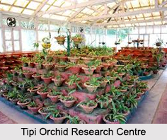
Tippi Orchid Research Centre, Arunachal Pradesh
Tippi Orchid Research Centre in Arunachal Pradesh is renowned for its rich collection of exotic and endangered orchids. Surrounded by lush rainforest...
Tourism in Nashik District
Pilgrimage tourism in Nashik district involves visiting the various places of Hindu and Jain worship located here. Some of the holiest sites for Hind...
Mangadu, Kerala
Mangadu in Kerala’s Kollam district is a significant megalithic site known for its urn burials, cist burials, menhirs, and stone circles. Excavations...
Devaswom
History of Devaswom is not very ancient and can be dated back to late seventeenth century.
Related articles in States of India

East Indian States
East Indian States comprises of Bihar, Jharkhand, West Bengal, Odisha and also the Union Territory of Andaman and Nicobar Islands. It defines the cult...

Purnia District in Bihar
Purnia District is located in Bihar and extends from River Ganga to Nepal. The district has a rich Hindu history and glorious past.

Hooghly district
Hooghly District along the bank of the river Hooghly is one of the principal trading ports of West Bengal.

Geography Of Chittoor District
Geography of Chittoor district is spread along the topography of the land which is divided into two natural divisions; Chittoor has a dry and healthy...

Districts of West Bihar
Districts of West Bihar is comprised of medieval monuments that were built by the different governors of Mughal era.