 Rangeet River is a tributary of the Teesta River, the largest river in the Sikkim. Rangeet River is also spelled as "Rangit River". The Rangeet Dam is built on this river which started operating since 2000. The reservoir which has been built behind the dam is developed into a recreational water park named "Rangit Water World". The Rangeet River has an NHPC hydropower plant with a capacity of 60 MW capacity in Sikkim. It provides various recreational facilities like fishing, boating and rafting.
Course of Rangeet River
Rangeet River originates from a glacier of Mount Kabru at the lower Kanchenjunga region. The river begins its course from the Himalayan Mountains in West Sikkim district. A perpetual river, Rangeet is fed by the melting snow of the Himalayas in early summer, and the monsoon rains in June-September. The convoluted river joins the Teesta at Teesta Bazaar on the periphery of West Bengal and Sikkim. During its final few kilometres, it forms the boundary between Sikkim and Darjeeling district of West Bengal. Rangeet River has the NHPC hydel plant of 60 MW capacities. The river flows past the towns of Pelling, Jorethang and Legship.
Rangeet Dam
The Rangeet Dam is built on Rangeet River in South Sikkim district of Sikkim. The project"s construction was completed in 1999 and started operating since 2000. The dam is situated at a distance of 130 kilometres from Siliguri and 70 kilometres from Gangtok. It is 45 metres high concrete gravity structure of 100 metres length. The reservoir constructed behind the dam has a storage capacity of 1,175,000 cubic metres. The reservoir is used for hydropower generation at a surface Powerhouse situated on the left bank of the Rangeet River.
Attractions of Rangeet River
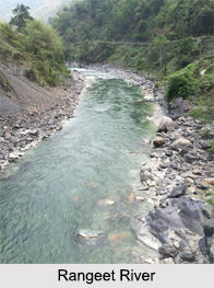
Rangeet River is popular among white water rafting enthusiasts because of its turbulent waters. It offers wonderful rafting opportunities to both beginners and experts. The river provides calm stretches that ensure safe rafting. The banks of the river are enveloped by thick forest cover. Certain areas of the banks are used for terrace farming. The water of this river is home to fishes like the Mahaseer, Katla, Trout, Asla and other species of Cat Fishes.
Rangeet River
Rangeet River is a major tributary of the Teesta River. The Rangeet Dam on Rangeet River is considered as the largest in Sikkim. Rangeet River is one of the finest rafting starches in the world.


