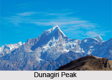
 Dunagiri peak is one of the highest peaks of the Garhwal Himalayas. On the basis of peakery data, it ranks as the 1st highest mountain in Uttarakhand and the 11th highest mountain in India. This peak"s beauty and aura is enchanting which lures mountaineers and explorers from various places of the world. Dunagiri was first climbed in the year 1939 by the Swiss climbers André Roch, F. Steuri, and D. Zogg, via the southwest ridge.
Location of Dunagiri Peak
It is located in the Uttarakhand state of India. The peak is perched at a height of 7,066 metres (23,182 feet) above mean sea level. It lies in the northwest corner of the Sanctuary Wall. The Sanctuary Wall is a ring of peaks surrounding the Nanda Devi and encircling the Nanda Devi Sanctuary. The geographic coordinates of the peak is 30°31`57 North, 79°50`02 East. The mountain prominence (it is a measure of vertical separation between mountains) of Dunagiri is 1,200 metres (3,900 feet).
Attractions of Dunagiri Peak
Dunagiri is a treat for the nature lovers. Enveloped with snow, this peak has enchanting and divine beauty which mesmerises people. It offers the longest view of the Himalayas in this region of Kumaon and Garhwal. It also provides the view of serene landscapes. The nearest peaks are Changabang, Nanda Devi, Hathi Parbat, Trisul, Rataban, and Nanda Kot.
Connectivity of Dunagiri Peak
The peak can be assessed from both sides of Kumaon and Garhwal by Ranikhet in kumaon and Joshimath in Garhwal.
This article is a stub. You can enrich by adding more information to it. Send your Write Up to content@indianetzone.com


