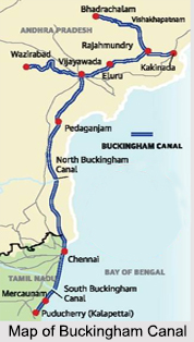
 Paralleling the Coromandel Coast of South India from Kakinada in the East Godavari district of Andhra Pradesh to the Villupuram District in Tamil Nadu, the Buckingham Canal stretches for almost 796 km. It is a fresh water navigation canal that connects most of the natural backwater along the coast to the Chennai port.
History of Buckingham Canal
Constructed during the British Rule, the Buckingham Canal was originally known as the Cochrane"s Canal in 1806, after Basil Cochrane who had financed the first segment. It was an important waterway during the late 19th and 20th centuries and was briefly renamed as Lord Clive"s Canal before finally being named the Buckingham Canal in 1878. The name acts as homage to the order of the Duke of Buckingham and Chandos, the erstwhile Governor of Madras, who ordered the extension of the canal to help people affected by famine.
The people of Chennai suffered greatly from the Great Famine of 1877 and 1878. More than 6 million people perished during this time and the 8 km stretch of the canal linking the Adyar and Cooum Rivers was built as a famine relief work. Initially, the canal was known as the North River by the British and it was believed that due to the canal, the damage caused by cyclone was less in the southern coastline of Andhra Pradesh and most of Chennai.
Phases of Construction of Buckingham Canal
Initially in 1806, the first segment of the Buckingham Canal was a saltwater navigation canal stretching for a distance of 18 km from north of Chennai to Ennore. Subsequently, the canal was extended 40 km north of Chennai towards the north of Pulicat Lake. In the year 1837, the Buckingham Canal was taken over by the government of the Madras Presidency and further extended. Ultimately, the canal reached about 315 km north of Chennai to gudivada kalava on the banks of the Krishna River in Andhra Pradesh, and 103 km south of Chennai to Marakkanam in Tamil Nadu.
 Course of Buckingham Canal
The Cooum River connects the Buckingham Canal to the Bay of Bengal in the centre of Chennai. The portion north of the Cooum is known as the North Buckingham Canal, and the portion south of the Cooum as the South Buckingham Canal. About 257 km of the canal is in Andhra Pradesh, and 163 km in Tamil Nadu and approximately 31 km is within the city limits of Chennai.
Decline in Usage of Buckingham Canal
Over the years, the Buckingham Canal has been subjected to both natural and industrial hazards and with time it has become damaged. The cyclones of 1965, 1966 and 1976 damaged the canal, and since then the use of the canal started to diminish as it was no longer well maintained. Industrial hazards that have damaged the canal include the release of hot water, fly ash by power stations and sewage and effluents that silt up the canal and leave the water stagnant, thus creating an attractive habitat for malaria-spreading mosquitoes. The Buckingham Canal is the most polluted of the 3 major waterways in the city with nearly 60 percent of the estimated 55 million litres of untreated sewage being let into it daily, including by Chennai Metropolitan Water Supply and Sewerage Board.
Within the city limits of Chennai much of the canal has been used as the route of the elevated railway line. Stations such as Kotturpuram, Kasturba Nagar and Indira Nagar have encroached on the canal and narrowed the width of the canal to less than 50 m in a few places.
Role of Buckingham Canal during Disasters
During the 2004 Indian Ocean tsunami, the Buckingham Canal acted as a safeguard zone and regulated the tsunami waves on the coastal area over almost 310 km from Pedda Ganjam to Chennai. The canal all along the coastline was packed with tsunami water, which poured out at a few places and retreated back to the sea within 10 to 15 minutes. This helped a long way in saving the lives of a number of fishermen, particularly in coastal Andhra Pradesh and fractions of the Chennai city and also helped in clearing the aquaculture remains. The natural growth of vegetation on both the sides of the canal also helped in lessening the impact of the tsunami.
In the year 2015, Chennai was affected by devastating floods, during this time Buckingham Canal drained water from south Chennai. But a 2014 CAG report has revealed that if the government had done effective planning of flood control projects, the flood water would have been drained at 3,500 cubic feet per second from the southern neighbourhoods in Chennai.
Revamping the Buckingham Canal
Periodic dredging up and widening of the Buckingham Canal through Water Resources Department is taken up by the Public Works Department (PWD) and the government of Tamil Nadu. With the provisions of State- Centre shared Jawaharlal Nehru National Urban Renewal Mission (JNNURM); PWD has started widening the South Buckingham Canal from Okkiyam Madu to Muttukadu for a stretch of 13.5 km.
Restoring this British era canal to its past glory is a task in itself.
Buckingham Canal
Built during the British Rule, the Buckingham Canal is a long fresh water navigation canal.


