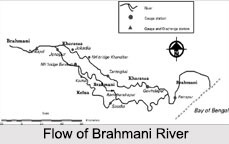
 Formed by the confluence of Sankh and South Koel rivers near the major industrial town of Rourkela, the Brahmani River is the second longest river flowing through the state of Odisha. It is one of the seasonal rivers that meander through the Eastern Ghats in the districts of Sundargarh, Deogarh, Angul, Dhenkanal, Cuttack, Jajpur and Kendrapara. The Brahmani River together with the Baitarani River forms a large delta before emptying into the Bay of Bengal at Dhamra.
Legend of Brahmani River
There is a mythological legend associated with the site of the Brahmani River"s origin. It is said that the site where the river originated is the place where Sage Parashara fell in love with the fisherman`s daughter, Satyavati who later gave birth to Ved Vyasa, the compiler of the Mahabharata. The place is thus called Ved Vyasa.
Overview of Brahmani River
Both the sources of the Brahmani River are in the Chota Nagpur Plateau, the Sankh River has its origin near the Jharkhand- Chhattisgarh border along with the South Koel River which also rises in Jharkhand. The Brahmani River flows for about 480 km and has a catchment area of almost 39,033 sq. km. If the constituent rivers are included, then the length of Brahmani extends to about 799 km, of which 541 km are in Odisha itself.
The Brahmani River winds generally south- southeast past Bonaigarh and Talcher and then turns east to join northern branches of the Mahanadi River, which then empties into the Bay of Bengal at Palmyras Point. The Brahmani delta that is formed at this point is the site of the Bhitarkanika Wildlife Sanctuary, famous for its estuarine crocodiles.
Irrigation Projects of Brahmani River
The Brahmani River is one of the few rivers that cut across the Eastern Ghats, and has formed a minor gorge at Rengali, where a dam has been built. Before the river enters Talcher, there is a barrage called the Sasmal Barrage. Other than this, the Jokadia and the Jenapur dams are the other irrigation projects on the river. The Brahmani River is also crossed, near its mouth, by the Orissa Coast Canal that takes water from it.


