Introduction
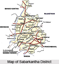 Sabarkantha District is located in the state of Gujarat. Himmatnagar is the district headquarters and talukas Prantij, Modasa, Talod are major industrial locations in Sabarkantha. The area of the district is 7390 sq. km.
Geography of Sabarkantha District
Sabarkantha district is bounded by the Rajasthan State to the north, Banaskantha and Mehsana districts to the west, Gandhinagar, Kheda, and Panchmahals districts to the south. Geographical location of the district is 23.03 degree North (Latitude) and 73.39 degree East (Longitude). The maximum temperature of the place is 40.5 degree centigrade and the minimum temperature is 9.04 degree centigrade. Hathmati, Sabarmati, Khari, Meshwo, Vatrak, Mazum, and Harnav are the main rivers flowing through this district. Average rainfall recorded here is 500-1000 mm.
Education in Sabarkantha District
The district has a government engineering college and one government polytechnic colleges, which offer courses in computer, electrical, mechanical and civil engineering. There are around twenty three government arts and commerce colleges as well as one pharmacy college spread across the district. Industrial Training Institutes (ITI) in the district impart training in areas such as cutting and sewing, armature and motor rewinding, computer operating and programming assistance, wiring, hair and skin care, fitting and stenography.
Demography of Sabarkantha District
 According to the Population Census in the year 2011, Sabarkantha District had population of 2,428,589 of which male and female were 1,244,231 and 1,184,358 respectively. In 2011, Sabarkantha District had population of 2,428,589 of which male and female were 1,244,231 and 1,184,358 respectively. The average literacy rate of Sabarkantha in 2011 was 75.79 compared to 66.65 of 2001. If things are looked out at gender wise, male and female literacy were 86.44 and 64.69 respectively.
Economy of Sabarkantha District
 Economy of Sabarkantha District in Gujarat is primarily agrarian. Agriculture and Dairy Farming are the most important occupation for the people of the district. Sabarkantha district is the chief producer of Ber (Indian Jujube), Cereals, and Pomegranate in the State. Sabar Dairy in Sabarkantha district manufactures and distributes diverse types of milk products. Production of large quantities of clay, silica sand and bauxite has opened up new avenues for the tiles, glass, fine bricks and crockery. Food processing and textiles are the other emerging sectors which have opened up opportunities for investment. Some key players having operations in Sabarkantha are Sabar dairy, Pathik Agrotech, Gujarat Ambuja Exports Ltd., Oracle Granite Limited, Eureka Tiles, and City Tiles Ltd.
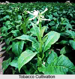
Major food crops like oilseeds, and fruits produced in the district comprise castor, wheat, groundnut, mango, tobacco, ber, and pomegranate. The district contributes to over ten percent of the overall potatoes produced in the State. Brinjal, tomato, cabbage, and cauliflower are the most important vegetable crops cultivated in the district. There are at present more or less forty two medium and large scale industries in Sabarkantha district. Walls and floor tiles (ceramics), chemicals, plastic and plastic products and commercial office and household equipments are some of the major small scale industry sectors of the district. Sabarkantha houses over 8,000 Small Scale Industries, employing close to 34,200 people. Other sectors such as food processing, cement, paper and pulp, textiles and chemicals have also been growing at a steady pace.
The region has advantages of rich agriculture base and accessibility of fertile land. Major section of the society depends on agriculture for their livelihood. Recent surge in the augmentation of ceramic industry in the district has enhanced employment potential. Production of large quantities of clay, silica sand and bauxite has opened up new avenues for the fine bricks, glass, tiles, and crockery industries. Small scale industry sectors such as food processing, vitrified tiles, wood products and chemical-based sectors or industries are the supporting pillars of the financial system. They provide direct and indirect employment to over 34,000 people in the district. Excellent road and rail connectivity to major districts of the State is playing a chief role in driving the economy of the district.
Tourism in Sabarkantha District
 Tourism in Sabarkantha district, Gujarat, is famed for being an excellent site for exploring the ancient past. Beautiful temples, palaces and forts stand gracefully in the district showcasing their admirable architecture and artistry. Ruins of several other structures also make the district an interesting excursion site. Many of them narrate the culture and events of the bygone era.
Idar : Idar State, also known as Idargadh, is a town situated at the north of Himmatnagar town. It is famed for huge black rocks. A massive fort stands in the town and solid hard black rocks surround it, protecting it from any kind of harm. The fort is located at an elevated ground from the surrounding region of the town, known as Idar hill. Rajput descendents of Bappa Rawal had captured the fort by defeating the Bhil rulers of this area. Carved steps can be found to reach the fort from the town. Near the fort there is an ivory like tower, known as Ruthi Rani nu Mahal (Palace of Sulking Queen) which was renovated by Kumarpal. Other places of attraction near Idar include Rao Ranmalla Chowki which derives its name form the famous poet who wrote poems to depict the brave actions of Kumarpal. A horse cave is also situated nearby. It is believed that the Chinese traveller Hiuen Tsang crossed this region and reached a village called Valabhi. Stone inscriptions have also been discovered which belong to 1208, 1219, and 1273 AD. At a little distance from the town, ancient temples of Roda are also present for which it has been predicted that a rich city was probably present here in ancient times. Remains of Vijayanagar Empire have also been found here. A museum is situated in the town which houses these photographs and sculptures.
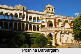
Poshina Darbargadh : Poshina Darbargarh is an elegant palace of Gujarat, situated in Poshina region of the district which was a small yet prominent kingdom of the past. It presently serves as a heritage hotel. It was built by the descendents of Chanakya, who ruled over Gujarat, at the foothill of Aravalli. The building is embellished with exquisite architecture. Around 17th century, this Darbargarh was constructed and immensely decorated for the royal guests. The place also gives a beautiful view of Ambaji Temple, Khedbrahma temple and the lain temples at Kumbhariya.
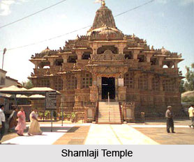
Shamlaji Temple : Shamlaji temple is one of the best Vishnu temples of Gujarat. It is situated amidst a spectacular landscape exhibiting an impressive architecture. The temple was erected in 15th century and later underwent several phases of renovation. Around the temple, ruins and mounds of other old temples can also be found and behind the temple is situated a beautiful lake known as Shyam Sarovar. Intricate artistic carvings adorn the pillars of the temple and the outer walls are profusely sculptured. Remnants of Viharas and Stupas have also emerged from nearby regions which suggest that the area was an important Buddhist centre once.
Sir Pratap Singh Palace : It is a magnificent palace situated in the district and is centuries old. It houses paintings of hunting scenes, portraits of English royalty, trophies and many other artefacts of ancient era.
Other Tourist Places in Sabarkantha : Other attractive tourist places in Sabarkantha district include a clock tower, the Shantinath temple, Polo forests and many other excursion sites.


