 Indian Geology is an important aspect of Indian geography, which deals with rocks, fossils and soil in the country. It traces back to the geological evolution of the rest of the earth, that is, before 4.57 billion years. Owing to its vastness, India has a diverse geology. Different regions in India contain rocks of various types belonging to different geologic periods. Some of the rocks are severely distorted and transmuted, while others are lately deposited alluvium. Mineral deposits of a great variety and in huge quantity have been found in the Indian geological surveys. The fossil records include stromatolites, invertebrates, vertebrates and plant fossils.
History of Indian Geology
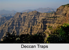
The Indian Plate is a tectonic plate, which was originally a part of the ancient continent of Gondwanaland from which it separated and eventually became a major plate. About 50 to 55 million years ago, it combined with the adjacent Australian Plate. It is today a part of the major Indo-Australian Plate and includes the subcontinent of India and a part of the basin under the Indian Ocean. The Indian Plate passed over a geologic hotspot namely, the Reunion hotspot during its journey northward, after breaking off from the rest of the Gondwana. This caused extensive melting underneath the Indian craton. The melting broke through the surface of the craton in a gigantic flood basalt event, creating what is known as the Deccan Traps. It is also known that the Deccan Traps was formed as a result of the sub-aerial volcanic activity associated with the continental deviation of the earth during the Mesozoic era. That is why the rocks derived from this region are generally of igneous type. It is also believed that the Reunion hotspot caused the separation of Madagascar and India.
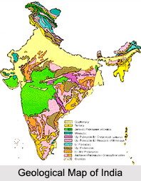
Geological Divisions of India
 India`s geographical land area can be categorized into the Deccan Trap, the Gondwana and the Vindhyan. The Deccan Trap covers almost the entire Indian state of Maharashtra, a part of Gujarat, Karnataka, Madhya Pradesh and Andhra Pradesh at its margin. The Gondwana and Vindhyan regions have within their folds parts of Madhya Pradesh, Chhattisgarh, Odisha, Bihar, Jharkhand, West Bengal, Andhra Pradesh, Maharashtra, Jammu and Kashmir, Punjab, Himachal Pradesh, Rajasthan and Uttarakhand. The Damodar and Son river valleys and Rajmahal hills in the eastern India are huge depositories of the Gondwana rocks.
Geological Society of India
Geological Society of India is an important organization dealing with Indian geological studies. It is based in Bengaluru and its flagship product is the Journal of the Geological Society of India (JGSI). Geological Society of India promotes the causes of advanced study and research in all branches of earth system science. A council having a term of three years administers the society. The President of the current council is the geologist namely, B. P. Radhakrishna.


