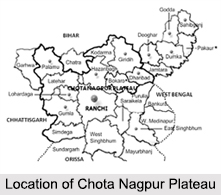
 Located in the north- eastern edge of theIndian peninsula, the Chota Nagpur Plateau covers much of the state of Jharkhand as well as adjacent parts of Odisha, West Bengal, Bihar and Chhattisgarh. Covering a total area of approximately 65,000 sq. km, the Chota Nagpur Plateau has the Indo-Gangetic Plain to the north and east of the plateau and the basin of the Mahanadi River lies to the south.
Etymology of Chota Nagpur Plateau
It is said that the name Nagpur has been derived from the word Nagavanshis, who were the rulers of erstwhile Odisha of the Nagavanshi Dynasty. And the word Chota is the name of a village in the outskirts of Ranchi, which has the remains of an old fort belonging to the Nagavanshis.
Formation of Chota Nagpur Plateau
A continental plateau, the Chota Nagpur Plateau has an extensive area of land thrust above the general land. The plateau has been formed by continental uplift from forces acting deep inside the earth. The ancient origin of the plateau can be dated back to the separation of the Gondwanaland. After it broke free from the southern continent during the Cretaceous period, the Chota Nagpur Plateau is now a part of the Deccan Plateau. The north- eastern part of the Deccan Plateau, where this eco region sits, was the first area of contact with Eurasia.
Divisions of Chota Nagpur Plateau
The region of the Chota Nagpur Plateau consists of a series of plateaus having different altitudinal extent. There are four plateaus having a variety of characteristics and nature as well:
Pat: First is the Pat region, which is the highest point in the western part of the plateau with an elevation of about 3500 ft above mean sea level. This region of the Chota Nagpur Plateau covers the north- western part of the Ranchi district and the southern edge of the Palamau Plateau. Having a flat top, the Pat region consists of dissected hills and composed of Deccan lava which later changed into lateritic and bauxite due to change in physical as well as chemical.
Ranchi Plateau: Known to be the largest part of the Chota Nagpur Plateau, this covers almost the whole of Ranchi district. Standing at an elevation of about 700 m, this highly dissected Ranchi Plateau gradually slopes down towards south-east into the hilly and undulating region of Singhbhum. The Damodar River originates here and thus the plateau is separated by a structural trough of the river from the upper Hazaribagh Plateau in the north and to the west is a group of plateaux called pat. There are many waterfalls at the edges of the Ranchi plateau like the Hundru Falls Dassam Falls, Sadni Falls, etc.
Hazaribagh Plateau: Consisting of gneisses and other Dharwar rocks, the Hazaribagh Plateau can be subdivided into two parts: the higher plateau and the lower plateau. Here the higher plateau is referred to as Hazaribagh Plateau and the lower plateau as Koderma Plateau.
The north-eastern and southern faces of the Hazaribagh Plateau are mostly abrupt. But to the west it narrows and descends slowly in the neighbourhood of Simaria and Jabra where it curves to the south and connects with the Ranchi Plateau through Tori Pargana. On the other hand the Koderma Plateau has the appearance of a range of hills, but in reality it is the edge of a plateau.
Palamu Division: Generally lies at a lower height than the surrounding areas of Chota Nagpur Plateau. On the east the Ranchi plateau intrudes into the Palamu Division and the southern part of the Division merges with the Pat region. On the west are the Surguja highlands of Chhattishgarh and Sonbhadra district of Uttar Pradesh. The Son River touches the north-western corner of the Division and then forms the state boundary for about 72 km.
Climate of Chota Nagpur Plateau
The Chota Nagpur Plateau has a pleasant climate with a mean temperature of about 23 degree Celsius in the month of December. From the month of October onwards for about 5 to 6 months, the Chota Nagpur Plateau experiences a sunny weather. With an average annual rainfall of about 1400 mm, the rainfall received in the Chota Nagpur Plateau is less than the rain forested areas of much of India and almost all of it in the monsoon months between June and August.
Ecology of Chota Nagpur Plateau
A tropical and subtropical dry broadleaf forests eco region encompasses the Chota Nagpur dry deciduous forests. These types of dry deciduous forest region are found on the fringes of the Hazaribagh Plateau where the average annual rainfall is below 125 cm. It comprises of a wide variety of stunted deciduous trees like Amallas, Semal, Asan etc. mixed with Bamboo and Sabai grass. The plateau receives less rainfall that makes the vegetation drier in this region.
The forests of the Chota Nagpur Plateau cover some of the rare and endemic species. It is home to the last population of the Asiatic elephants, Royal Bengal Tigers , gaur, bison, spotted deer, four horned antelopes, etc. The dry deciduous forests of the plateau also harbour more than 400 species of birds. Some of the important known species among them includes the florican, Indian Grey Hornbill and the Oriental pied hornbill among others.
There are also several protected areas of Chota Nagpur Plateau, among them the largest protected areas are the Palamau Tiger Reserve and the Sanjay Gandhi National Park. It is said in the year 1997, about 6 percent of the eco region"s area was within protected areas comprising of about 6,720 sq. km. The number has increased since then with an increase in national parks and sanctuaries.
Mineral Resources of Chota Nagpur Plateau
The Chota Nagpur Plateau is a store house of mineral resources such as mica, bauxite, copper, limestone, iron ore and coal. The Damodar valley is rich in coal and it is considered as the prime centre of coking coal in the country. It is said that the Chota Nagpur Plateau holds 80 percent of India"s known coal deposits and 100 percent of cooking coal. Massive coal deposits are found in the central basin. Apart from these, various other minerals like apatite, asbestos, byrites, chromite etc are found in Singhbhum and the atomic mineral uranium is mined at Jadugora.
Inhabitants of Chota Nagpur Plateau
Munda, Oraon, Ho and Santhal are the major tribal groups, which are inhabited in the forest areas of the Chota Nagpur Plateau. These indigenous people are seen using the groves of the Sal tree as Sarnas or place of worship. They have their fairs and festivals celebrated only among them. Some of them are Sarhul, Karam, Tasu Parab, Hal Punhya, Rohin and many more.


