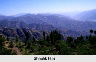
 Shivalik Hills are a sub-Himalayan Mountain Range running 1,600 km long from the Teesta River, Sikkim, through Nepal and India, into northern Pakistan. The range runs parallel with the Himalayan system from Haridwar on the Ganges to the banks of the Beas River. The hills have an average height of 900 to 1,200 m. They are chiefly composed of low sandstone and conglomerate hills, the solidified and up-heaved detritus of the great range in their rear, the intermediate valley lying between the outer hills and the Mussoorie. The hills consist of 6000 meters of layered rocks. They are known as the sub-Himalayas or the foothills and were formed by the erosion caused by the rise of the Himalayas.
Etymology of Shivalik Hills
Shivalik Hills is also known as “Manak Parbat" in ancient times. The word "Shivalik†literally means "tresses of Lord Shiva". Other spelling variations used include Shiwalik and Siwalik, originating from the Hindi and Nepali language. Other names include "Churia Hills", "Chure Hills" and "Margalla Hills".
 Geology of Shivalik Hills
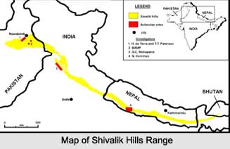
Shivalik Hills extends to west-northwestward for more than 1,000 miles (1,600 km) from the Teesta River in Sikkim state, north-eastern India, through Nepal, across north-western India, and into northern Pakistan. The width of the Shivalik Hills varies from 10 to 50 km and their average elevation is 1,500 to 2,000 m. It rises abruptly from the plain of the Indus and Ganges rivers in south and parallels the main range of the Himalayas in the north, from which it is separated by valleys. The Shivalik Hills are sometimes considered to include the southern foothills of the Assam Himalayas, which extend eastward for 400 miles (640 km) across southern Bhutan to the bend of the Brahmaputra River. Nepal"s portion of the range is called the "Churia Range".
History of Shivalik Hills
Once peppered with small principalities and kingdoms, straddling major trade routes in and out of the interior Himalayan regions, they prospered, till their eventual eclipse commenced during the British rule.
Demography of Shivalik Hills
People of the Lepcha tribe inhabit the Sikkim and Darjeeling areas. There is low population density in the Shivalik Hills and along the steep southern slopes of the Lower Himalayan Range.
 Flora and Fauna of Shivalik Hills
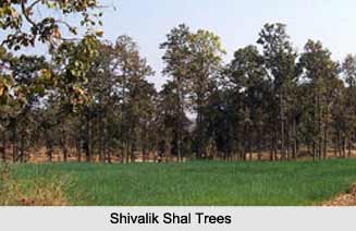
The "Patli Dun", forms part of the Corbett National Park, is one of the only regions of the Shivalik Hills to preserve its flora and fauna. The valleys are roofed with thick grasslands and the slopes have lush Sal forests. The forests abound in animals are Barking Deer, Spotted Deer, Tigers, rivers glow with Masheers and Gharials.
Vegetation at Shivalik Hills
Shivalik Hills has shallow erodable soils, which makes it unsuitable for agricultural production. The forests consist mainly of chir-pine and tropical mixed hardwoods of which Sal is often a major component. Middle-upper Shivalik have grassland type of vegetation. Maize, wheat, millet and mustard are the main crops produced in the Shivalik hills. The availability of irrigation water makes it suitable for the production of Rice.
Tourism in Shivalik Hills
Some places are being promoted as tourist destinations nowadays like the "Renuka Lake". "Shivalik Fossil Park", the capital of Himachal Pradesh, Shimla is a charming little hill station located in the Shivalik Hills, and many temples are center of attraction for travellers in the Shivalik Hills. All these points make the Shivalik hills an ultimate paradise of beauty and peace.


