 Adilabad District is a district located in Telangana. This district was earlier included with Andhra Pradesh. Adilabad District also comprised of major cities and towns like Mancherial, Chinnur, Adilabad, Nirmal, Bellampally, Kagaznagar, Mandamarri, Bhainsa, and Utnoor.
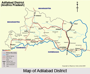
Location of Adilabad District
Adilabad District is a district in Telangana. On the North, the district is bounded by Yeotmal. On the east by, Chanda District, on the South by Karimnagar District and Nizamabad district and on the West by Nanded district of Maharastra State. Adilabad District is situated between 77.46 degree East and 80.01 degree East, of the eastern longitudes and 18.40 degree North and 19.56 degree North of northern latitudes.
Adilabad district occupies an area of 16,128 km square. The Sahyadri Mountains or Satnala range traverses the district from the north-west to the south-east for about 281.5 kilometers. The rivers that drain the district are the Godavari River, the Penganga River, Wardha River and Pranahita River. The two tributaries of the Godavari River are Kadam River and the Peddavagu River. Godavari River rises in the Western Ghats and enters this district near Basara, which is in the Mudhole Taluk.
The climate of Adilabad District is characterized by hot summer. The place experiences a dry climate in general. Rainfall is received during the south-west monsoon season. The normal annual rainfall of the district is 1044.5 m.m. Cold weather commences towards the end of November. The coldest month is December.
History of Adilabad District
 Adilabad District derives its name from the ruler of Bijapur, Ali Adil Shah. The district witnessed the rise and fall of different dynasties namely, the Mauryan Empire (Dynasty), Satavahana Dynasty, Vakataka Dynasty, Chalukyas of Badami, Rashtrakuta Dynasty, Chalukyas of Kalyani, Mughals, Bhosle Rajes of Nagpur and Asaf Jahis.
In 1905, Adilabad District was carved out of a sub district named Sirpur-Tandur. Historically the city was open to diverse variety of cultures as it was ruled by different rulers. At present, the district incorporates elements of Marathi culture into its native Telegu culture. Adilabad was once part of Maharashtra but its borders changed since 1945 and hence became a town in Telangana.
Geography Of Adilabad District
The climate of Adilabad District is characterized by hot summer and is generally dry except during the south-west monsoon season. The year may be divided into four seasons. The cold season from December to February is followed by the summer season from March to May. The period from June to September constitute the south west monsoon season, while October and November from the post-monsoon season. The rainfall in the district, in general increases from the south-west towards the north east. About 85% of annual rainfall is received during the south-west monsoon season. July being the peak rainy month. The variation in the Annual rainfall from year is not large. The normal Annual rainfall of the district is 1044.5m.m. There is a meteorological observatory, station at headquarters Adilabad. The cold weather commences towards the end of November when the temperature begins to fall rapidly. December is generally the coldest month, with the mean daily maximum temperature at about 29 degree C and the minimum daily is 15 degree C.
The relative humidity is high generally during the south-west monsoon season. The air is generally dry during the rest of the year, the distinct part of the year being the summer season when the humidity in the afternoon is 25%. During the south-west monsoon season the sky is heavily clouded. There is rapid decrease of clouds in the post-monsoon season. During the rest of the year the sky is mostly clear of light clouds. Winds are light to moderate with some strengthening in the period from May to August. During the post-monsoon and cold season, winds blow mostly from the east or north-east. By March, south-westerlies and westerlies start blowing and continue during the rest of summer. The sought west monsoon season winds are mostly from directions between south-west and north-west.
The Sahyadriparvat or Satnala range traverses the district from the north-west to the south-east for about 281.5 Kms. In this range the Mahbubghat is the hightest peak. In the eastern portion of the district some hills and hillocks are of minor importance.
The Godavari river is the most important river that drains the district. The Pengange, the Wardha River, and the Pranahita River come next importance. The Kadam and the Peddavagu are tributaries of River Godavari. Besides these, there are also rivulets like the Satnala, the Swarna vagu, and the Suddavagu which drain the district. The Godavari, which is the largest river in peninsular India, rises in the Western Ghats mountain range at Trambakeshwar near Nasik in Maharastra state and enters this district near Basara in Mudhole Taluk. This mighty river forms the boundary of the district separating the district from Nizamabad and Karimnagar districts and skirts the southern borders of Chennur, Luxettipet, Khanapur, Nirmal and Mudhole taluks. The penganga forms part of the northern boundary of the district in Adilabad, while the wardha and the Pranahita from the northern and eastern boundaries of the district, skirting east - while Sirpur and Chennur taluks respectively. The Kadam River takes its origin at Bothai village in erstwhile Sirpur and Chennur taluks respectively and flowing across the Bothai taluk it enters Khanapur at Paspula and finally falls into Godavari. The Peddawagu flows across the erstwhile taluks of Asifabad and Sirpur.
Demography of Adilabad District
The total population of the district is 20, 82,000 out of which the tribal population is 3, 55,000 as per 1991 census. The Tribal Population works out to be 17.78 % to the total population of the district. A number of different groups of the Tribals i.e., Gond tribe, Naikpods, Kolams, Pardhans, Koyas, Manne, Andhs, Thoties, Lambadas and Yerukalas tribe are living in the district. The Kolams and Thoties are the most backward and poorest and classified as Primitive Tribal Group (PTG) for special attention. Even the poorer Mannes (Telugu Speaking Kolams) are extended with the same benefits with a special government order. The Integrated Tribal Development Agency (ITDA) came in to existence on 1-8-1975 with head quarter at Adilabad. The head quarter was shifted to Utnoor in September, 1979. ITDA extends over 45 mandals covering (412) Scheduled Villages, (234) Non Scheduled Villages (TSP) and (12) cluster villages in the district. The tribal sub-plan area comprises (646) villages covering an area of 6353 Sq. Kms which works out to be 38.13 percent of total geographical area of the District.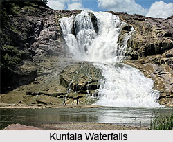
Administration Of Adilabad District
Administration of Adilabad District in Telangana deals with the political and the administrative units with the headquarter Adilabad, the main city of Adilabad District.
Administrative History of Adilabad District
These were ruled at different points of time by rulers from different dynasties- the Maurya empire, Satavahana dynasty , Vakatakas, Chalukyas of Badami, Rashtrakutas dynasty, Chalukyas of Kalyani, Mughal empire, Bhosle Rajes of Nagpur and Asaf Jahis, besides the Gond Rajas of Sirpur and Chanda. Originally this was not full fledged district but a sub-district named Sirpur-Tandur which was created in A.D. 1872 with "Edlabad" (Adilabad), Rajura and Sirpur as its consistuency talukas. In 1905 the status of this sub-district was raised to that of an independent district with head quarters at Adilabad.
Villages and Mandals of Adilabad District
Adilabad district in Telangana, a newly formed state in India with the capital Hyderabad for 10 years consists of 52 Mandals and 1743 villages of which 1557 villages are inhabited and 186 villages are un-inhabitated. There are a total of 7 municipalities in the district. For the purposes of convenience in administration, the district has been conveniently formed into five divisions. These include-1) Adilabad, 2) Nirmal, 3) Utnoor, 4) Asifabad and 5) Mancherial. Adilabad district has two Parliament Constituencies and nine assembly constituencies. The Adilabad District is administrated through five revenue divisions named above, consisting of a total of 52 mandals. The revenue division is made in a manner such that the District Revenue Officer (D.R.O) reports to the Joint collector (J.C.) who in turn reports to the district collector. At the division level, the Revenue Divisional Officer (R.D.O) - for Adilabad, Utnoor, Asifabad, Nirmal Divisions- reports to the sub-collector for the Asifabad division. At the Mandal level, the Mandal Revenue Officer (M.R.O) is followed by the Deputy MRO who is then followed by the Mandal Revenue Inspector (RI).

Development of Adilabad District
The administrative facilities of the state are quite up to date with health, road, electricity and irrigation facilities well provided for. Quite a few hospitals are available in the Adilabad district including the District hospital, Adilabad; Area Hospital, Mancherial; Community Hospital, Bellampally etc. Adilabad is well connected by means of an extensive road network, with the major district roads running a total length of 389.750 km. The State highways cover a length of 141.278 km whereas the newly taken over Panchayat Raj roads run a course of 293.110 km taken all together. The undulating nature of the terrain of the district lends itself favourable to irrigation from canals, wells and streams, with canals forming the main source of irrigation. The total irrigated area accounts for 11.5% of the total cropped area while the relative percentage of the state is 37.3%. The district has got 28 Electrical sub-stations, of 6412 kilovolts of high tensions and 10090 kilovolts of low voltage lines. 11566 villages have been electrified accounting for 99% and 17614 agricultural pumpsets are energised. Three type of Electrical sub-stations in Adilabad District. They are- One 220/132 KV Sub-station; six 132/33 KV Sub-station; sixty-five 33/11KV Sub-stations, all forming a total of seventy two electrical sub-stations in the Adilabad district.
Economy of Adilabad District
Agriculture is the main economy of the people of Adilabad District. Most of the people are farmers. The total cropped area of the district is 5.93 lakh hectares, which constitute 37% of the total geographical area. The principal crops are jowar, paddy, cotton, wheat, maize, chillies, sugarcane and soya. The area at present under the plantations and horticulture crops is only about 3.5% of the net area cultivated in the district. Horticulture produce assumes importance for it provides, supplementary income including foreign exchange and employment. Paddy production account for 10.8% pulses and each crop, and non food crops for 34.7% of the total cropped area. The cultivable wastes and fallow lands can be put to use by plantation on the contours and bunds of the farmlands.
With the above average rainfall, the district is suitable for horticulture comprising of fruits, vegetables and flowers. There are areas where medicinal and aromatic plants are cultivated. Sericulture is another form of economy in Adilabad District. Less than thousand areas of Adilabad District are under mulberry cultivation. Due to the heavy amount of transactions involved in cotton business, this city is also known as "City of Cotton". Animal Husbandry is only second to agriculture in terms of contributing to the gross income and employment in the district. The livestock consists of cattles, buffaloes, sheep, goats, poultry etc.
The Southern part of the area is better developed agriculturally due to the availability of better irrigation facilities here. Cotton occupies an important place in the agriculture sector of this district. With the above average rainfall, the district and minor irrigation facilities in general is suitable for horticulture comprising of fruits, vegetables and flowers. Sericulture is an activity making roads into this non-traditional area, with the implementation of National Sericulture project from 1989-90. The major constraint hampering the progress of sericulture activity has been the marketing of cocoons. In addition to the traditional mulberry, cocoons, tusser is another important area suitable in this forest area. The agro- climatic conditions are most suitable for sheep and livestock rearing, and animal husbandry is a major sector in the agriculture of the Adilabad district.
Culture of Adilabad District
Culture of Adilabad district in Telangana comprises the art, architecture, language, cuisine, handicrafts and a myriad other culture that reflect the essence of South India. These have been passed down from generation to generation and go into maintaining the culture of the place. The inherent nature of a place is contained within these well-preserved elements.

Toy Making: In Adilabad district, toy-making crafts and Dhokra casting crafts are very popular. They form a significant part of the culture of the place. Among the various places, Nirmal is well-known for toy-making, while Ushagaon, Jamgaon & Keslaguda village of Jainoor & Kerameri Mandal are known for Dhokra casting. They have provided a natural location for world famous toys and Dhokra casting. The artisans at Nirmal produce articles of artistic content and features. These works of art reflect the local life and environment. The current trend focuses on making animals, birds, fruits and vegetables. These are extremely well made and most realistic looking in appearance.
Dokra Craft: The Dhokra-casting artisans have been living in the region for the past 100 years. They are well-known for making tribal ornaments and zoomorphic figures, in particular horses, elephants either with or without riders, birds, animals bells and lamps.
Efforts have been made to stimulate the growth of toys of Nirmal and Dhokra casting at Jamgaon and Ushagaon villages of Jainoor mandal. The artisans have been organised along co-operative lines with a view to- helping it serve as an instalments for generating employment, and, to offer the public a variety of artistic products. Also these co-operatives have been created with the intent to extend financial assistance and various common facilities and other benefits to promote production and marketing of products. Presently the following 3 societies- 2 for toy making one for Dhokra casting- are functioning in Adilabad district.
1) Nirmal Toys and Arts ICS Ltd. Nirmal
2) Nirmal painting and decorative furniture Mfg. ICS Ltd. Nirmal
3) Jangubai Tribal Brass Handicrats ICS Ltd. Jamgaon (V) Jainoor (M)

The sales are made locally, through the Lepakshi and Exhibitions. These toys and Dhokra Craft are popular in the national and international market also, especially in the American and European Societies. Beside the above, the Dist. Industries Centre, Adilabad officers have made a survey on Handicrafts produced by the artisans at Adilabad. During the survey the following hidden crafts were identified. The stone carving at Ichoda; wood Carving at Adilabad; Bhorown Crafts at Shanthinagar of Gudihathnoor Mandal; Bamboo Handicrafts Articles at Kamana of Wankidi Mandal. All taken together, these are the various handicrafts of the Adilabad district.
Tourism in Adilabad District
Adilabad District has a number of tourism spots which include Kuntala waterfalls situated at Kuntala village, Pochera waterfall, Ruyadi piris, Mathadivagu project in the district as part of a new plan for tourism promotion. Pochera waterfall is situated about 6 km. from the National Highway 7 in Neredigonda mandal. While on the other hand, Kuntala waterfall is situated about 12 km. away from the National Highway 7 from Neredigonda mandal headquarters. There are other tourist attraction spots like Kawal Wildlife Sanctuary, Sivaram Wildlife Sanctuary, Pranahitha Wildlife Sanctuary, SRSP Project Dam, Kadem Dam, Sathnala Dam, Penganga Reservoir. It is believed that the famous astronomer Aryabhatta wandered in this region. Some of the other temples and mosques in this district are Jama Masjid, Gulzar Masjid, Madina Masjid, Nagoba temple, Satyanarayana temple, Convent Church, Pranahita Wildlife Sanctuary and Shivaram Wildlife sanctuary.
Nature Tourism in Adilabad District
Nature Tourism in Adilabad District in Telangana covers with the Kuntala Waterfalls, Pochera Watrefalls, and Kaddam Water Project. The waterfall at Kuntala village is 60 kilometers away from the Adilabad headquarters. The other famous waterfall, at Pochara is situated at a distance of 53km from the Adilabad headquarters.

Pilgrimage Tourism in Adilabad District
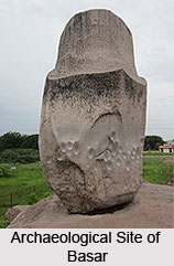
One of the most visited pilgrimage sites in the Adilabad district is the Sri Gyana Saraswathi Temple at Basara. The Basar Saraswati Temple is located 150 kms from the main district on the banks of the Godavari River. It is the only temple in South India dedicated to the Goddess of learning. Legend has it that after the Great War or the Mahabharata, sage Ved Vyas embarked on a journey in his quest for peace. He reached the serene Kumaranchala hills on the banks of Godavari river and meditated and propitiated the Goddess who eventually appeared before him and granted her presence in the form of the divine trinity. The Goddess ordered the sage to place three handful of sand at three places everyday. Miraculously these sand dunes transformed into the idols of the divine trinity i.e., Goddess Saraswati, Goddess Lakshmi, and Goddess Kali. These are the presiding deities of Basar today. Despite the presence of the trinity, the temple is dedicated to Goddess Saraswati. The temple is a popular place of worship. Children are brought here for the ceremony of Akshara puja to start their education with the blessings of the Goddess of Knowledge. During the Mahashivratri festival, thousands of devotees bathe in the Godavari and seek the blessings of the Goddess. Other places of interest around Basar are the Vedavathi Sila and the Ashtateerth.

Leisure Tourism in Adilabad District
The Kaddam Project is an existing major project across Kaddam river, a tributary of Godavari near Peddur village, Kaddam mandal in Adilabad District of Telangana. The project is envisaged to irrigate an ayacut of 68,000 acres. The land under irrigation here is intended primarily for the purposes of production of the kharif crop. The Kaddam Project has been integrated with Sriramasagar Project. The reservoir is being supplemented through the Sriramasagar Project and the Saraswathi Canal to stabilize the localized ayacut. Kaddam Project has three Distributory Committees and 26 Water User. It is a beautiful site often visited by those who visit the district.


