 Himalayan Rivers are associated with Himalayan Mountain Range. India is identified and acknowledged as the land of rivers, with water bodies covering more area. Gurgling along rough terrain and bounteous meadows, the umpteen rivers that saturate Indian mainland are cardinal to ancient Indian history as well as Indian mythology. From every corner of the country, Indian rivers can be witnessed meandering their ways and draining themselves into the Arabian Sea or Bay of Bengal. Leaving aside southern India and western India to some extent, rivers in the country mostly drain from the forever snowy Himalayas. The geography, topography and climate of the Himalayan range together affect the origin of certain rivers in the midst of mountains, which flow in a pre-destined course. Himalayan Rivers hold special significance in India, owing to their capacity to irrigate dry lands all the year round. They facilitate vegetation and consequently create food security in the country.
Principal Himalayan Rivers
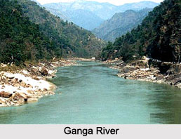
The principal Himalayan Rivers comprise the Indus River, the legendary Ganga River and the Brahmaputra River. These rivers are both naturally snow-fed and rain-fed and hence perennially flow throughout the year.
Secondary Himalayan Rivers
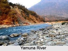
The secondary Himalayan Rivers that chalk out its origin and course in the Himalayan ranges include Sutlej River, Chenab River or Chandra Bhaga River, Beas River, Ravi River, Jhelum River, Yamuna River and Spiti River.
 Features of Himalayan Rivers
During the period of the Himalayan uplift, the cavernous valleys with precipitous rock sides were forged by the down-cutting of the rivers. Himalayan rivers discharge approximately 70 percent of their inflow into the sea. This however includes approximately 5 percent discharge from central Indian rivers. In the final course, these rivers unite with the Ganga and drain into the Bay of Bengal. All the Himalayan Rivers originate in the unknown and uncharted territories amidst snow and mist and eventually restrict themselves within the northern, north-eastern and eastern regions of India. The courses of the Himalayan Rivers change in between. The rivers from the Himalayas separate and further divide into tributaries and distributaries. For instance, Yamuna River serves as the largest tributary of Ganga River. Himalayan Rivers take the shape of enormous basins during the time of their inflow. Forceful erosion is one factor up the streams, making the rivers to carry huge load of sand and silt. Reaching the plains, the rivers take the shape of depositional features like flood plains, river cliffs and levees. Nearly all the rivers from the Himalayas produce enormous plains and are navigable over long distances of their path.
Usefulness of Himalayan Rivers
With overflowing and perpetual data, scientists and geographers in India are striving hard to make Himalayan Rivers useful and utilizable in the adjacent Indian states and surroundings. The rivers are harnessed in their upstream catchment area to generate hydroelectricity.


