 The state of Uttarakhand is located in the northern part of India. It has some of the holiest Hindu shrines, rivers, temples, monuments, forest reserves, national parks, hill stations and mountain peaks. They have not only beautified this state but have also made Uttarakhand one of the famous tourist destinations of India. Dams of Uttarakhand are also vital aspects of the state. They play an important role in the development of Uttarakhand and also affect lives and settlement in the state. Some of these dams are described below.
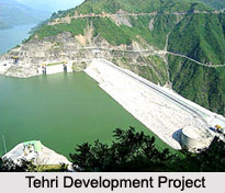
Tehri Development Project
Tehri Development Project (TDP) began as the Tehri Dam, which is a major hydroelectric project centered near the Tehri town in the state of Uttarakhand. The dam measures about 855 feet in height and is believed to be the 5th tallest dam in the entire world. The Tehri Dam is located in the Seismic Gap of the Central Himalayas. The area of its location is also known as a major geologic fault zone. As a result, the region is highly earthquake prone but the founders of the dam claim that it can withstand an earthquake of a magnitude of about 7.2 on the Richter scale. The main purpose of the Tehri Dam was power generation of a capacity of about 2400 megawatt. It also caters to the irrigation requirements of an area of about 270,000 hectares.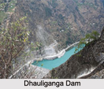 Supplying 270 million gallons of drinking water per day to the industrialized areas of Delhi, Uttar Pradesh and Uttarakhand is another major function of the dam.
Koteshwar, a part of the TDP hydroelectric plan is a smaller dam, constructed about 14 km downstream. It produces around 400 megawatt of electricity.
Dhauliganga Dam
Dhauliganga Dam is another dam in the state of Uttarakhand. It has been built under the Dhauliganga Power Plant Project and has been constructed at the border triangle between India, Nepal and China of the Indian Himalayas. The dam has been raised to a height of about 56 meters and is a concrete-faced rock filled dam. The crown length of this dam is about 270 m. The cut-off wall of Dhauliganga Dam is located at the upstream toe of the dam and it is built in the diaphragm walling process. The thickness of the dam is about 1 meter and water reaches to a depth of about 70 meter with a total area of about 8000 square meters. The construction and functioning of the dam is supervised by a joint venture of Kajima Corporation (Japan) and Daewoo Corporation (Republic of Korea).
Haripura Dam
Haripura Dam is located in the Udham Singh Nagar of Uttarakhand. The dam has a height of about 10.98 m and a length of about 7980 m. Irrigation was the reason behind the construction of the dam. The construction of the dam was completed in the year 1975.
Ichari Dam
Ichari Dam is located in Dehradun district of Uttarakhand. The dam has a height of about 59.25 m and a length of about 155 m. Generation of hydroelectricity was the reason behind the construction of the dam. River Ganga forms the basin of Ichari Dam. The construction of the dam was completed in the year 1972.
Maneri Dam
Maneri Dam is located in Uttarkashi district of Uttarakhand. The dam has a height of about 39 m and a length of about 127m. Generation of hydroelectricity was the reason behind the construction of the dam. The construction of the dam was completed in the year 1984.
Other Dams in Uttarakhand
Some of the other Dams in Uttarakhand are Nanak Sagar Dam, Ramganga Dam, Dhora Dam and Koteshwar Dam.
Dams In Uttarakhand
The names of some of the Dams in Uttarakhand are Tehri Development Project, Dhauliganga Dam, Haripura Dam and Ichari Dam.


