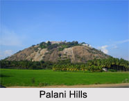
 The Palani Hills are a range of mountains which cover the states of Kerala and Tamil Nadu. The hills are actually an eastward extension of the Western Ghats, which are located aligned to the west coast of India. Sprawling over an area of 2068 square kilometers, Palani Hills get neighboured with the Anamalai range on the west, Kerala and it extends to the plains of Tamil Nadu on the east. The highest part of the range is in the southwest where the elevation ranges 1,800 -2,500 meters. The eastern part of the range has an elevation of 1500-1000 meters.
Geography of Palani Hills
Vandaravu peak is the highest peak in the Palani Hills range. The range lies between the Cumbum Valley on the south, which is drained by the Vaigai River, its upper effluents, and the Kongu Nadu region (western part of Tamil Nadu) to the north. The northern shields are drained by the Shanmukha River, Nanganji River, and Kodavanar River, which are effluents of the Kaveri River. The range lies mostly within Dindigul district, except in the western portion. In the western portion it forms the boundary between Dindigul District and Theni District to the south and Idukki District to the south west. Palani Hills join the Anamalai Hills and the Cardamom Hills at Anamudi peak in Kerala.
Vegetation in Palani Hills
The vegetation of the hills varies from elevation to elevation. The lower elevations of the Palani Hills between 250 to 1000 meters have the South Western Ghats"s moist deciduous forests ecoregion. Above 1000 meters, there are the evergreen South Western Ghats"s montane rain forests and the vegetation changes to mosaic shoal grassland comprising of frost tolerant montane grasslands.
Visiting Information to Palani Hills
There is a temple on the hill dedicated to Lord Karthikeyan or Murugan, one of the revered Gods in Tamil Nadu. In the southern central portion of the range there lies the hill station of Kodaikanal.
This article is a stub. You can enrich by adding more information to it. Send your Write Up to content@indianetzone.com


