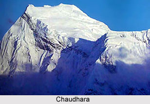
Chaudhara - Informative & researched article on Chaudhara
  Indianetzone: Largest Free Encyclopedia of India with thousand of articles Geography of India


in  
Art & Culture | Entertainment | Health | Reference | Sports | Society | Travel
Forum  | RSS Feeds  | Free E-magazine
Geography of India : Indian Climate l Indian Mountains l Indian Forests l Indian Soil l Indian Vegetation l Animal Husbandry in India l Resources in India l Indian Demography l Indian Industries l Indian Islands l Indian Airports l Zoos in India l Indian Mines & Minerals l Indian Physiography l Indian Transport l Indian Geology l Communication in India l Indian Trade l Indian Astronomers l Indian Telecommunications
Home > Reference > Geography of India > Indian Mountains > Mountain Peaks of India > Chaudhara
Chaudhara
Chaudhara is a Himalayan mountain peak which is a part of the Kumaon subdivision situated at a height of 6,510 metres.

ChaudharaChaudhara is a mountain peak located in the Pithoragarh district of Uttarakhand. The peak is situated at a height of 6,510 metres (21,358 feet) above mean sea level. This Himalayan mountain peak is a part of the Kumaon subdivision. The peak lies in the south direction of Ralam pass and in the northwest of Panchuchuli. The peak has four corners and therefore it is called Chaudhara.

The peak is close to the Nanda Devi Sanctuary. The neighbouring peak is Rajrambha, Panchchuli and Nandakot. Chaudhara is located at the southeast end of Kalabaland Glacier-Sankalp Glacier-Yangchar Glacier group. Chaudhara peak is part of the Himalayan massif that comes between Ralam valley and Lassar Valley. The peak is accessible via the west face. The geographic coordinates of Chaudhara peak is 30°16`48?North, 80°22`12?East.

From the Ralam village one can get a magnificent view of the Chaudhara peak.

(Last Updated on : 22/01/2009)
  More on Mountain Peaks of India...
 
Anamudi Peak Arwa Group Avalanche Peak
Burphu Dhura Peak Changabang Peak Changuch Peak
Chembra Peak Chiring We Peak Dunagiri Peak
Guru Shikhar Peak Hardeol Peak Kamet Peak
Kodachadri Peak Nagalaphu Peak Nanda Pal Peak
Nilkantha Peak Om Parvat Peak Panchchuli Peaks
Phalut Peak Rajrambha Peak Rimo I Peaks
Saltoro Kangri Peak Suj Tilla East Peak Tadiandamol Peak
Teram Kangri Peaks Trisuli Peak Abi Gamin
Agastya Malai Mountain Balakun Bamba Dhura
Chaudhara Nanda Kot Nanda Devi
Rishi Pahar Kanchenjunga Peak Mount Mawma Peak
Suitilla Peak Siniolchu Peak Suli Top
Doddabetta Peak Chhiplakot Peak Sandakphu Peak
Swargarohini Anginda Peak K12 Peak
Kalsubai Peak Mount Abu Peak Nanda Devi East Peak
Nanda Gond Peak Nun Kun Peaks Sangthang Peak
Sispara Peak Trisul Peaks Badrinath Peak
Yamunotri Peak Moon Peak Kapilash Peak
Recently Updated Articles in Geography of India
  • Grand Trunk Road
    Grand Trunk Road is one of the oldest, longest and most important roads of South-Asia.
  •  
  • Types of Forests in India
    Elevation, topography, climate and soil type are the major factors which determine the type of forest.
  •  
  • Sispara Peak
    Sispara Peak is an Indian mountain peak, situated in the south Indian state of Tamil Nadu.
  •  
  • Indian Railway Zones
    Indian Railway network is classified into seventeen zones for administrative purposes.
  •  
E-mail this Article | Post a Comment
Free E-magazine
Subscribe to Free
E-Magazine on Geography of India

 
Chaudhara - Informative & researched article on Chaudhara
Sitemap
Contact Us   |   RSS Feeds
Copyright © 2008 Jupiter Infomedia Pvt. Ltd. All rights reserved including the right to reproduce the contents in whole or in part in any form or medium without the express written permission of Jupiter Infomedia Pvt. Ltd.