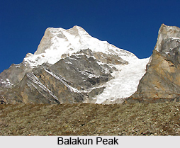
 Balakun is one of the beautiful peaks situated in the Uttarakhand state of India. It is a snow clad Himalayan peak. According to the peakery data, Balakun ranks as the 26th highest mountain in India and the 11th highest mountain in Uttarakhand. The peak is located at a height of 6471 meters (21,230 feet) above mean sea level in the Garhwal region. Balakun was first scaled in the year 1973 by Hukum Singh and his team.
Location of Balakun
The peak is located in the Chamoli district of Uttarakhand. It is positioned at a distance of 16 km from Badrinath which is a holy town.
Attractions of Balakun
The beauty of this snowy peak lies in its location. It is surrounded by various other beautiful peaks. Balakun is situated in the northwest direction of Badrinath between the Bhagirath Kharak and Satopanth glaciers. In its northeast direction is situated Nilkanth peak. The Alaknanda River starts off from below this peak by the merging of the above mentioned two glaciers at an altitude of 3,641 m. Owing to the origin of Alaknanda River from below this peak, it is considered sacred by the Hindus. The two glaciers rise from the eastern slopes of Chaukhamba peak which is located at a height of 7140 meters above mean sea level. The glaciers beautifully wrap around the Balakun peak. Balakun is situated north to the Kunaling and south to the Arwa Group of Himalayan Peaks.
This article is a stub. You can enrich by adding more information to it. Send your Write Up to content@indianetzone.com


