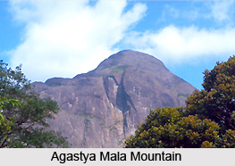
 Agastya Mala is a famous mountain situated in South India. Locally, it is also referred as Agastyakoodam. Agastya Mala Mountain is popular among the mountaineers, trekkers, explorers and photographers. This mountain is also well-known for being a home to various herbs and medicinal plants. Every year people from various corners of the world flock to this mountain.
Location of Agastya Mala Mountain
Agastya Mala Mountain is situated in the Western Ghats of South India. It is located at a height of 1,868 metres (6129 feet) above mean sea level. Agastya Mala Mountain lies at the border between the states of Kerala in Kollam and Thiruvananathapuram districts and Tamil Nadu in Thirunelveli district. Agastya Mala Mountain is located at a distance of thirty-two kilometres from Neyyar dam.
Attractions of Agastya Mala Mountain
This peak is a part of the Agasthyamala Biosphere Reserve which lies on the border between the states of Kerala and Tamil Nadu. The Agasthyamala Biosphere Reserve houses a variety of rare flora and fauna including medicinal plants and endangered animals. This peak offers a glimpse of the Palk Straits on a clear day. The Agastya Mala is the source of the perennial river Thamiarabarni, which flows in the Thirunelveli district of Tamil Nadu. This peak is a major pilgrimage centre for devotees of the Hindu sage Agastya. Agastya is one of the seven rishis of Hindu Puranas. There is a statue of Agastya at the top of a peak where devotees can worship him and place their offerings. The lower elevation of the Agastya Mala is known for the availability of rare herbs and medicinal plants. Nearly two thousand medicinal plants used in Ayurvedic treatments are found here.
Trekking at Agastya Mala Mountain
One can trek the peak only with prior permission from the forest department of Kerala. The trekking route begins from Bonacaud and is open to trekkers from January to mid-March.
Connectivity of Agastya Mala Mountain
The mountain can be assessed via railway and airway. The nearest airport is the Trivandrum International Airport at a distance of sixty-one kilometres and the nearest railway station is the Ambasamudram in the district of Tirunelveli.


