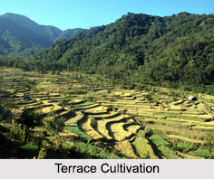
 Terrace Cultivation is seen in the hilly areas of Arunachal Pradesh and Nagaland. In Meghalaya and Mizoram, it is seen in some areas. Gradually, it is becoming popular among the hill tribes of the region due to the scarcity of cultivable land and the evil effects of Jhum Cultivation. Terrace Cultivation is becoming popular in Nagaland, especially among the Angamis. They have an elaborate system of terracing and irrigation by which they turn the steep hillsides into water logged rice fields. Terrace Cultivation is receiving wide appreciation and people are beginning to embrace this method of farming.
Process of Terrace Cultivation
The method of preparing land for Terrace Cultivation is to convert the side of the hill slopes into terraces of 2 to 20ft broad or more. The walls of the terrace field are banked up with stones dug out of the soil. The land is irrigated by the channels, which carry water from some hilly stream or torrent. Sometimes water is brought from miles away through channels to feed the terrace fields. Each terrace, of course, cannot have its own channels. Therefore, water is usually obtained either from the terrace above or from one of the terraces in the same row. The terraces are so carefully prepared that water may flow from terrace to terrace round a whole spur and back again to a point little below from which it entered. Seedlings are usually ready for transplantation at the beginning of June. However, the seasons may vary according to the altitude and climate. After transplantation, the terraces are weeded two or three times. The harvest is usually ready by the end of October or the first half of November.
Production in Terrace Cultivation
Rice is the principal crop grown in the terrace fields of North East India. In addition to this other crops are also generally grown in small quantities. These are pears, maize, beans, peas, oilseed, gourds, cucumbers, chillies, spinach, mustard, "kachri" (colocasia antiquorum), potatoes, etc. Traditionally, the wet fields are left barren during off-season for the cultivation of vegetables. In the Khasi Hills, various types of vegetables such as cabbages, cauliflowers and potatoes are grown. Spices such as ginger, turmeric, chillies are also in the list.
Terrace Cultivation is one of the preventive measures against soil erosion. This can be carried on as a means to secure overall development in agriculture sector in the hilly regions of North East India. Adopting Terrace Cultivation can protect the natural eco-system depleted by Jhum Cultivation.