Introduction
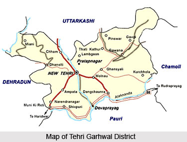 Tehri Garhwal District is one of the administrative districts of Uttarakhand. New Tehri is its headquarters. Earlier, Narendra Nagar was the district headquarters. Tehri Garhwal District stretches from the snow clad Himalayan peaks like Thalay Sagar Peak and the Gangotri group of Mountains all the way to the foothills near Rishikesh. Bhagirathi River which runs through seems to divide the district into two, while the Bhilangna River, Alaknanda River, Ganga River and Yamuna River border it on the east and west. Its neighbouring districts are Uttarkashi District, Chamoli District, Pauri Garhwal District, Rudraprayag District and Dehradun District.
Location of Tehri Garhwal District
Tehri Garhwal District is located on the outer ranges of the mid Himalayas which comprise low line peaks rising contiguously with the planes of the northern India. The district lies between the parallels of 30 degree 3 minutes and 30 degree 53 minutes north latitude and 77 degree 56 minutes and 79 degree 4 minutes east longitude. Uttarkashi District from the north, Rudraprayag District from the east, Pauri Garhwal District from the south and Dehradun District from the west are bounding the district. On the western front Yamuna river separates it from Jaunsar Pargana of the Dehradun district while Bhagirathi rising from the north of Gangotri River in the district Uttarkashi touches the district near village Nagun.
History of Tehri Garhwal District
 History of Tehri Garhwal District before the establishment of Panwar Dynasty is not very clear. Kanak Pal was the first ruler of the region. It is said that the prince Kanak Pal who hailed from Malwa visited Badrinath (presently in Chamoli district) where he met the then mightiest king Bhanu Pratap. King Bhanu Pratap was impressed with the prince and got his only daughter married to him and also handed over his kingdom. Gradually Raja Kanak Pal and his descendents extended their empire by conquering all the forts of Garhwal region. Thus up to 1803 that is for around 915 years the whole of Garhwal region remained under their control.
Further, according to the history of Tehri Garhwal District, during 1794 and 1795 Garhwal was under the grip of severe famine and again in 1883, the country was terribly shaken by an earthquake. Gorkhas had by then started invading this territory and heralded their influence over the region. The people of the region being already affected by natural calamities were in the terrible condition and therefore could not oppose the invasion of the Gorkhas.
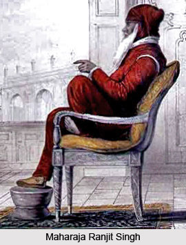
On the other hand, Gorkhas whose several attempts for capturing the fort Langur Garhi had earlier failed were now in a powerful position. Therefore, in 1803, they again invaded Garhwal region when King Pradyumna Shah was the ruler. King Pradyumna Shah was killed in the battle in Dehradun but his only son (King Sudarshan Shah was minor at that time) was cleverly saved by the trusted courtiers. With the victory of Gorkhas in this battle their dominion was established in Garhwal region. Later on their kingdom extended up to Kangra and they ruled over this region continuously for 12 years before they were thrown away from Kangra by Maharaja Ranjit Singh. On the other hand Sudarshan Shah could manage help from East India Company and got his kingdom freed from Gorkha rulers. The East India Company merged Kumaon, Dehradun and east Garhwal in the British Empire and the west Garhwal was given to Sudarshan Shah which was then known as Tehri Riyasat.
King Sudarshan Shah established his capital at Tehri town and afterwards his successors Pratap Shah, Kirti Shah and Narendra Shah established their capital at Pratap Nagar, Kirtinagar and Narendra Nagar respectively. Their dynasty ruled over this region from 1815 to 1949. During the Quit India Movement people of this region actively participated in the freedom struggle of the country. After the independence of the country in 1947, the inhabitants of Tehri Riyasat started their movement for getting themselves freed from the clutches of Maharaja. Due to the movement the situation became out of his control and was difficult for him to rule over the region. Consequently the 60th king of Pawar Vansh Manvendra Shah accepted the sovereignty of Indian Government. Thus in 1949 Tehri Riyasat was merged in Uttar Pradesh and was given the status of a new district.
Geography of Tehri Garhwal District
A major portion of Tehri Garhwal District is hilly tract. The plain area is more fertile than the plateau area. Bulk of the area of the district is under forests which occupy a place of importance not only in the ecology but also in the economy of the district. These forests are rich in vegetations. Wood of commercial value is produced. These forests are also famous for production of herbs and plants of medicinal value. There has been a denudation of forests in the past, resulting in impoverishment of forests wealth. Under five year plans efforts have been made to plant trees under forestations programmed. Availability of soft wood has given rise to the manufacturing of wooden toys in the area. Tehri Garhwal District is rich in diverse species of flora and fauna. The chir, oak, conifers, Sal, deodar, haldlu, rhododendron, the birch, horse chestnut, willow, alder and various types of fruit trees like the cornel, the figs, the mulberry, the kingora, the raspberry, the blackberry, currants, gooseberries, hazelnuts, apples, pears, cherries, apricots, plums, peaches, oranges, limes, bananas, pomegranates and walnuts are found in the district besides a variety of herbal plants bushes, scrubs and grass. Tehri Garhwal District has been the habitat, from times immemorial, of a large variety of mammals, birds, reptiles and fish. Further, the district is rich in avifauna and in particular pheasants, partridges, pigeons and doves of various kinds which are the chief game birds.
Culture of Tehri Garhwal District
The hilly terrains and lack of easy communications have helped the district to preserve its indigenous culture intact. Several important fairs and festivals are celebrated in Tehri Garhwal District. Important fairs and festivals organized in different parts of the district include Chamba Thoulu, Gajtfa Thoulu, Dharu Mela, Suri-ka-Mela, Bandwal Gaon, Agram Thoulu, Churiya Kheti Thoulu, Kamand Thoulu, Badshahee Thoulu, Jamti-ka-Mela, Kothyara, Gali, Sem Mukhan, Sri Kunjapuri Yatra, Pali Thoulu, Digoli Thoulu, Bikhot, Nagendra Devta, Chandra Badni, Banjagri, Jagdajat, Chameshwar Mahadev, Vasant Panchami and many more.
Flora of Tehri Garhwal District
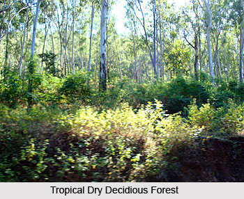 Flora of Tehri Garhwal District varies from the sub-tropical species which grow in the outer ranges of low hills to the rich Alpine flowers in the north. It consists of mostly such trees that grow in its forests because large tracts of the land-surface in the district constitute forests. Flora of Tehri Garhwal District can be divided into six main botanical divisions namely the tropical dry deciduous forests, Sal forests, chir forests, the oak forests, the deodar, fir and spruce forests, and the Alpine pastures.
Tropical Dry Deciduous Forests: These forests occur mostly near Yamuna River and on the foothills and extend up to the altitudes of 1,200 metres. The predominant species are kuri, kemela, jhingan, and mandar. The chief undergrowths are dhaula, binda, basingha and the gandela.
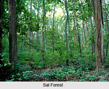
Sal Forests: These forests exist up to the altitude of 1,066 metres, their best growths being found in the valley of the Bandal in tehsil Tehri. Small tracts of the Sal forests may also be seen in the neighbourhood of Muni ki Reti and Shivpuri in tehsil Dev Prayag. Sal is highly gregarious. The upper limit of Sal is regulated to a great extent by frost. In excessively dry localities, it gives way to more xerophytic species. It does not extend beyond the outer ranges of the Himalayas even though the main river valleys in the northern part of the district are much below the maximum elevation at which this species may grow. It is commonly found up to the altitude of 762 metres on the southern aspects and 1,066 metres on the northern. The other chief trees found in these forests are sain, bakli, jhingan, haldu, kanju, sandhan, rohini and amaltas. The wood of the sandhan is used for making agricultural implements. Grass abounds in Sal forests, wherever sufficient light reaches the ground. In most Sal forests, Sal comprises 80 to 90 percent of the dominant tree species and tends to form a dense tree canopy. The Sal forests had originally contained a much higher percentage of miscellaneous species.
 Chir Forests: These forests ordinarily extend on the southern aspects from 1,000 metres to 2,150 metres and on the northern aspects from 900 metres to 2,000 metres throughout the district, growing best in the valleys of the Bhilangana and its tributaries, Alaknanda River and Mandakini. Chir is found on almost all geological formations though, on certain southern slopes with limestone subsoil, it is not found because of the dryness of the soil coupled with relatively high temperatures. Nevertheless, chir forests can establish themselves on dry southern aspects where owing to xerophytic conditions and the prevalence of fires, few other trees or shrub species survive. In all chir forests, pine is the dominant tree species present though, on the northern aspects where, there is more moisture in the soil and fires are less destructive, scattered trees of there species also occur.
Chir forests are seldom very dense. The ground is covered with grass, sometimes dense, whatever the aspect of density or overhead canopy, and there is also a discontinuous undergrowth of shrubs, often so widely scattered that even from a short distance their presence is scarcely noticeable. The open nature of these forests, the absence of other tree species and the scarcity of the undergrowth are attributable to fires which have in the past swept annually throughout their length and breadth, to the xerophytic conditions under which they grow and to the fact that the chir is often located near tracts under cultivation which leads to its heavy lopping and felling. Towards its lower limit, chir gets mixed up with trees of miscellaneous species and, less frequently, with sal forests. The chir is tapped for resin and its wood is used for building purposes. The seed also yields oil and, when baked, it becomes edible.
Deodar Forests: These forests occur in the northern part of Tehri Garhwal District in tehsil Pratapnagar in a small area, associated with blue pine and cypress between the altitudes of 1,520 metres and 2,150 metres above sea level. The forests are open and the trees do not attain great height. Fir and Spruce forests also occur in the northern part of Tehri Garhwal District between the altitudes of 2,150 metres and 3,050 metres. Wherever silver fir occurs, it is the dominant species excepting when it occurs mixed with spruce even where, it is equally important.
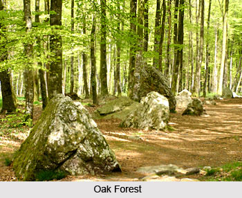 Oak Forests: The three principal oaks are banj, moru and kharsu, each occupying more or less a distinct altitudinal zone in the district. Banj forests are ordinarily found between the heights of 1,800 metres and 2,150 metres above sea level. They also occupy moist ravines running down into the chir zone where they reach levels as low as 1,050 metres. A notable feature of banj forests is its capacity to establish itself on the most unfavourable southern aspects. Those on the northern aspects are comparatively denser. On southern aspects, the ground is almost invariably clothed with dense grass, while on northern aspects the incidence of grass is much less. The banj has a large number of shrubs associated with it. Moru forests are found at between 1,980 metres and 2,750 metres above sea level and occupy an intermediate zone between banj and kharsu, which form extensive forests on the southern aspects, where the moru occurs sporadically. It attains its maximum development at elevations between 2,125 metres and 2,450 metres on moist soils and especially where the subsoil is limestone.
The kharsu forests occupy very extensive tracts at heights between 2,350 metres and 3,500 metres in the northern part of tehsil Pratap Nagar (except in the north-east) and in the north-eastern part of tehsil Devprayag. It is found equally on the northern and southern aspects and has few successful competitors, excepting silver fir and moru. The fir, however, occurs only on a small fraction of the area occupied by kharsu. At its upper limit, moru passes into forests of birch and silver though, on southern slopes, it more frequently passes directly into pastureland without any gradual transition. Typical khasru forests are dense, the most common associate being burans, which is almost as abundant in the kharsu forests as it is in the banj forests. Shrubs also occur in diverse varieties.
Alpine Pastures: These are found in the north eastern part of Tehri Garhwal District in tehsils Pratap Nagar and Devprayag between heights of 3,500 metres and 5,000 metres above sea level. The land in these parts is covered with snow from October to May but, from June to September, varieties of grasses, herbs, shrubs and flowers grow in the area in abundance. The area provides beautiful and extensive pasture lands for the cattle. On the northern aspects, birch is also found.
Large variety of herbal plants bushes, scrubs and grass are also found in the district.
Tourism in Tehri Garhwal District
 Tourism in Tehri Garhwal District offers an enriching and tranquil experience to the visitors. Tehri Garhwal District is one of the prominent tourist destinations of the country as it offers several popular places of interest that are worth visiting. Almost all the major town of Tehri Garhwal District offer a panoramic view of the snow clad mountains and peaceful nature. Some of the main tourist sites of Tehri Garhwal District are mentioned below.
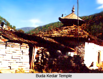
Buda Kedar Temple: This temple is situated at the confluence of Bal Ganga River and Dharam Ganga River, at a distance of 59 kms from Tehri. It is believed that Duryodhana offered tarpana here. According to legends, it is at this temple that Pandavas encountered Rishi Balkhily at Bhrigu Parbat when they were on the lookout for Lord Shiva after the battle at Kurukshetra.
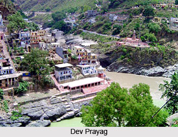 Dev Prayag: Situated at the confluence of Alaknanda River and Bhagirathi River, the town of Dev Prayag lies at about 87 km from Narendra Nagar. Near the town there are two suspension bridges, one each on the rivers Bhagirathi and Alaknanda. The town is one of the five sacred Prayag (confluences) of the Alaknanda. Tradition has it that the town is named after Deosharma, a sage, who led a life of penance here. Raghunathji Temple is claimed to have been erected some ten thousand years ago and is dedicated to Lord Rama. It is located in the upper part of the town and consists of an irregular pyramid capped by a white cupola with a golden ball and spire. Religious ablutions take place at two basins excavated in the rock at the junction of the holy streams - on the Bhagirathi known as the Brahma Kund and the other on the Alaknanda called the Vashishta Kund. The temple is visited by a large number of pilgrims every year. Besides the temple of Raghunathji, there are several other popular temples and shrines in this town of Tehri Garhwal District. From this place, one can have a magnificent view of Dasharathachal Peak.
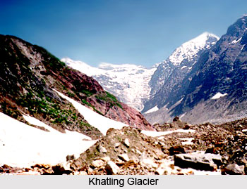
Khatling Glacier: The trek for Khatling glacier starts from Ghuttu, a place about 62 kms from Tehri. The other important places are Reeh, Gangi, Kalyani and Bhomakgufa. The site of the Khatling glacier is most spectacular and alluring.
Narendra Nagar: 14 kms away from Muni-ki-Reti at an altitude of 1,129 metres lies this capital of the former king of Garhwal. Until a few years ago it was the headquarters of the District Tehri Garhwal, but now the New Tehri town is the headquarters. Here, the palace of the Tehri Raja is situated amidst a forest. Situated on the main Rishikesh-Gangotri-Yamunotri route, Narendra Nagar offers a fine view of peaceful Ganga River and the beautiful Doon Valley. The sun set view from here is particularly attractive. At a height of around 2903 metres, situated in the interior of the district, the temple of Nag Raja at Sem Mukhem is held in high esteem by the people of the area. The temple is situated at the top of a hill about 5 kms from the village Mukhem which is 2 kms from the motor head of Khamba Khal.
Chamba: 60 kms from Mussoorie and 48 kms from Narendra Nagar on the road to Gangotri. Chamba is a township lying high at an altitude of 1676 metres, offering a splendid view of the snow-capped Himalayas and the serene Bhagirathi valley. Chamba happens to be a focal point, being located at the junction of all major roads leading from Mussoorie, Rishikesh, Tehri and New Tehri. The Chamba-Mussoorie fruit belt is also famous for its delicious apples.
 Dhanolti: Dhanolti, located amidst thick, virgin forests of Deodar, Rhododendron and Oak, has an atmosphere of perfect peace and tranquility. The long wooded slopes, relaxed outdoors, cool crossing breeze, warm and hospitable inhabitants, lovely weather and fabulous view of snow covered mountain makes it an ideal retreat for a relaxed holiday.
Kunjapuri: Kunjapuri is the name given to a peak having an altitude of about 1,676 metres. It commands a beautiful view of the snow-ranges of the Himalayas and of the valley of the Bhagirathi. It contains an old temple dedicated to the goddess Kunjapuri Devi which is visited by a number of people every year.
Surkanda Peak: Surkanda peak lying at an altitude of 2,750 metres in the western part of tehsil Tehri, and is famous for the temple of Surkanda Devi. It is about 8 kms from Dhanolti on the motor road running from Mussoorie to Chamba and is well connected with Narendra Nagar. Flowers of varied kinds and colours and indigenous herbs grow in abundance here and some of the beautiful birds of the western Himalayas are also found in the neighbourhood. A local fair is held on the occasion of Ganga Dussehra in Jyestha when hundreds of devotees visit this place.
Chandrabadani: Chandrabadani is well known for the temple of Chandrabadani Devi which lies at the top of the mountain about 10 km north of Kandi Khal, 22 kms from Dev Prayag and 109 km from Narendra Nagar. Some popular legends are associated with this place. There are some old statues and lots of iron trishuls (tridents) outside the temple. It commands a beautiful view of Surkanda, Kedarnath Mountains and Badrinath peak.
Nagtibba: For those who are interested in trekking and adventure, Nagtibba offers them all the opportunities. The area is full of dense forests and natural beauty. One can have a panoramic view of the Himalaya Mountains.
These tourist sites along with the amazing scenic beauty attract travellers from all parts of the country.