Home > Indian History > Geography of India > Shanmuga Nadi River
Shanmuga Nadi River
Shanmuga Nadi River is a river and the ghats nearby are popular of the people who come to visit the temples nearby.

Share this Article:

Shanmuga Nadi River, Palani, Tamil Nadu
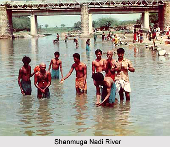
Shanmuga Nadi River is a river that had religious zeal among the local people like the Ganga River. Shanmuga Nadi River has many religious bathing ghat in the Town of Palini in Tamil Nadu.

The bathing ghats on Shanmuga Nadi River are located at a distance of three kilometres from Palani town and can be reached from Adivaram. During the solar and lunar eclipses and on the days of the waning moon (new moon) thousands of people who believe in Hindu mythology flock here to have their sins absolved in the purifying waters. Kavadi bearers have a bath here before marching to the temple.

The Shanmuga Nadi ghat is also a place for oblations to the dead; the devout perform the after death rituals to deceased ancestors. There are many shrines on the banks of the river near the bathing ghat and elsewhere.

Periya Avudayar Kovil of all these temples, that of Peru-Udayar (called Periya Avudayar Kovil) is by far the most important and deserves special mention. Located near the railway line on the banks of the Shanmuga Nadi is in sylvan setting.

In the dawn and dusk, the natural beauty of this river and the ghat nearby will take the tourists in the feelings that they are in Varanasi. The unpolluted and fresh atmosphere is favourable for the thinkers and the people who are long in city pent. The Devasthanam has put up a Kalyana Mandapam behind the temple.

The temple is dedicated to Peru Udayar or Brihadeesvarar a name that became a legend in the days of the king of Chola Dynasty, Raja Raja Chola or Rajaraja Chola I. The deity here is a Swayambhu linga and so, local belief is that it existed even before Bhogar. Only male gods are found in the temple. A majestic figure of Lord Dakshinamurti, a rare Rudran and other gracious images in stone, as also the 16 old inscriptions are notable here.

This article is a stub. You can enrich by adding more information to it. Send your Write Up to content@indianetzone.com


Share this Article:

Related Articles

More Articles in Geography of India


Geography of Uttar Pradesh
The fourth largest State in India UP is located in the Northern part of India whose area is 2,36,286 sq Kms.
Geography of Maharashtra
Covering an area of 308,000 sq. km, Maharashtra, the third largest state in India.
Geography of Kerala
Geography of Kerala includes plains, hills, valleys and coasts. With the Arabian Sea in the west, the Western Ghats in the east and networked by several rivers, Kerala enjoys diverse geographical features.
Geography of West Bengal
The geography of West Bengal is unique with high peaks of the Himalayan range in the north, the Bay of Bengal in the south and the remaining region is covered with both plains and plateaus.
Geography of Jharkhand
Geography of Jharkhand is comprised of the rich mineral resources and the highly agricultural prospect in this state.
Geography of Sikkim
Geography of Sikkim is characterised by a vast array of magnificent hillock that extends from one corner of the state to the other.
Geography of Meghalaya
The suitable climate, highland plateaus, rivers and the flora and fauna together forms the geography of Meghalaya.
Geography of Mizoram
Mizoram is surrounded by hills, valleys, rivers, waterfalls and lakes. The hills range from 1000 meters to 2000 meters. Rivers, lakes and waterfalls also play major role in forming the land of Mizoram.
Geography of Jammu & Kashmir
Jammu and Kashmir is encompassed by valleys. Some of the dominant valleys of the state are Kashmir Valley, Tawi Valley, Chenab Valley, Poonch Valley, Sind Valley and Lidder Valley etc. Jhelum River is the only major Himalayan River which flows through the Kashmir valley. Indus, Tawi, Ravi and Chenab Rivers are the major ones flowing through the region.
Geography of Daman and Diu
Daman and Diu is situated on the west coast of India and are the smallest union territories of India.
Geography of Goa
Geography of Goa occupies a prime location along the Konkan coastal belt on the western coast of India. The state is bordered by Maharashtra in the north and Karnataka in the south. The Western Ghats in the east contribute to the flora and fauna of Goa.
Geography of Arunachal Pradesh
Geography of Arunachal Pradesh reveals that it is a hilly tract nestled in the foot of Himalayas.
Geography of Kutch
Geography of Kutch District is covering an area of 45,612 km. Kutch District is the largest district in the state of Gujarat.
Geography of Ladakh
Geography of Ladakh mainly comprises the huge Karakoram Range with long stretch of cold desert which mark the region separately from the rest of the states of Indian subcontinent. Surrounded with the mountain ranges from all corners this small region separates Indian subcontinent from rest of the Asian continent.
Geography of Rajasthan
Geography of Rajasthan defines the dry topography with arid climate of the western mountain region.
Geography of Tamil Nadu
The Indian state of Tamil Nadu is located in the Northern hemisphere in the hot zone.