 Sendamangalam is located in Namakkal District in the Indian state of Tamil Nadu. It is a panchayat town that serves as the headquarters of Sendamangalam Block. Sendamangalam assembly constituency is under the Namakkal Lok Sabha constituency.
History of Sendamangalam
According to history Sendamangalam served as the capital of Kopperunchinga I and Kopperunchinga II, the kings of Kadava Kingdom from 1216 to 1279 CE. They transformed the town into a military base. The kings fought several battles against Rajaraja Chola III, Kulothunga Chola III, Hoysala kings, and Jatavarman Sundara Pandyan from the town. The Kadava kings maintained friendly relations with the Magadai chief `Magadan Rajarajadevan pon parappinan Magadaipprumal` and the Tirukoilur chief Malayaman. Later the campaigns of Maaravarman Kulasekara Pandyan I destroyed the kingdom. The town was also known for the Nainamalai Temple.
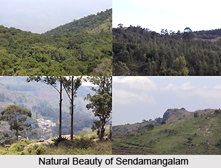
Geography of Sendamangalam
Sendamangalam is located at 11.3000°N latitude and 78.2333° E longitude. The town has an average elevation of 240 metres above the sea level. Kaveri River flows by the town and the Kolli Hills, a part of the Eastern Ghats mountain range adorn its beauty. Sendamangalam is located at a distance of almost 350 kms southwest of Chennai, 50 kms away on the southern side of Salem, 255 kms away to the southern side of Bengaluru and 93 kms northwest of Tiruchirapalli. The temperature here varies from 20 to 44 degrees Celsius.
Educational Institutions of Sendamangalam
Sendamangalam has set up many schools to promote education among children. Some of the notable schools in the town are:
| * Viveka Educational Institutions |
| * Viveka Special School |
| * Viveka Public School |
| * Viveka Matriculation School |
| * Viveka Tutorial College |
| * Govt. Girls H.S. School |
| * Govt. Boys H.S. School |
| * Viveka Tuition Centre |
| * GHSS Muthugapatty |
Sendamangalam is well connected by all modes of transports. The town is located at a distance of 12 kms northeast from Namakkal. It is on the 54 kms long State Highway SH-95 that links the towns, Mohanur, Namakkal, Muthugapatti, Akkiampatty, Sendamangalam, Gandhipuram, Kalappanaickenpatti and Rasipuram. The town is 12 kms away from Namakkal, 45 kms away from Karur, 50 kms way from Salem, 62 kms away from Erode and 93 kms away from Tiruchirapalli. The state capital Chennai is situated at a distance of 380 kms from Namakkal. The nearest railway station is located at Salem at a distance of 55 kms. The nearest airport from Sendamangalam is in Salem almost 55 kms.


