Home > Travel > States of India > Rajnandgaon District
Rajnandgaon District
Rajnandgaon District is a district in the state of Chattisgrah with the administrative headquarters in the Rajnandgaon town.

Share this Article:

Rajnandgaon District came into existence on 26th Jan` 1973, by way of division of Durg District. Rajnandgaon state was ruled by Somvanshis, Kalchuris and Marathas. It was originally called Nandgram, but it was again divided on 1st July 1998 and the new district of Kawardha was formed. Situated distinctly on the lap of nature the place is surrounded by numerous beautiful ponds and rivers which adds to the attraction of the region. The remnants of the palaces and towns whisper its own tale of the rulers, their society and culture and the splendid tradition during that time. The contribution of Gajanan Madhava Muktibodh, Padumlal Punnalal Bakshi and Baldeo Prasad Mishra in the field of Hindi literature has a special mention. The District Kawardha was later bifurcated from the District on 1st July 1998.

Rajnandgaon District History of Rajnandgaon District
The Rajnandgaon was originally called Nandgram. The Rajnandgaon state was ruled by Somvanshis, Kalchuris and Marathas. The contribution of Gajanan Madhav Muktibodh, Padumlal Punnalal Bakshi and Baldeo Prasad Mishra in the field of Hindi literature has a special mention. The city was also ruled by the Gond Rajas. The foundation of the city can be traced to a religious celibate, who descended from Punjab towards the end of the 18th century. Until 1879 it was ruled through succession and later the British Government identified the ruler as a hereditary chief and thus bestowed upon his son the title of Raja Bahadur. The chief rulers had been Mahant Ghasi Das, Raja Mahant Balram Das Bahadur, Raja Mahant Balram Das Bahadur, Mahant Rajendra Das, Mahant Sarveshwar Das. The last ruler, Ghasi Das was recognized as a feudal chief by the British government in 1865 and was granted a sanad, or right of adoption.

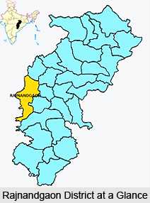
Geography of Rajnandgaon District
The District Rajnandgaon lies in the central part of Chhattisgarh. The District headquarter Rajnandgaon is on the Mumbai - Howrah line of south-eastern railways. Even the National Highway 6 (Great Eastern Road) also passes through the town of Rajnandgaon. The nearest airport to the District is at Mana (Raipur), about 80 kms away. The principal river of the District is Sheonath which thrives to be the tributary of Mahanadi. The river originates in the border of Chowki block and flows in north eastern direction. The main tributaries of Sheonath are Kharkhara, Sonbarsa, Amner, Surhi, Karra, Murkati, Sankari, Fonk and Hanf. The three blocks of the District namely Mohla, Manpur and Chowki are tribal blocks. The main tribes of the District are Gond, Kanwar, Halba & Baiga. The tribal population of the District is around 25.16% of the total population. These tribal areas are adjoining to Gadchiroli District of Maharashtra and Bastar District of Madhya Pradesh. The economic and social conditions of these tribes are similar to that of tribal of Bastar. They mostly live in far flung areas and dense forests. The economic activities of these tribes are focused on tendu leaf collection and minor forest products.

Festivals of Rajnandgaon District
Diwali is one the most celebrated festivals of Rajnandgaon. It is known as the `festival of lights and crackers. Ganesh Chaturthi is another festival celebrated in honour of Lord Ganesha. Even the Ganpati Visarjan is enthusiastically done in Rajnandgaon. On the Visarjan Day people take out huge Jhakki, chanting names of `Ganpati Bappa Morya.`

Sports of Rajnandgaon District
The District has a rich culture of sports, which has produced many national and international sports personalities. Rajnandgaon District is well know as Nursery of Hockey and has a great history of organizing Hockey and Cricket tournaments every year at international and national level respectively.


Share this Article:

Related Articles

More Articles in States of India


East Indian States
East Indian States comprises of Bihar, Jharkhand, West Bengal, Odisha and also the Union Territory of Andaman and Nicobar Islands. It defines the cultural heritage, rich historical background and the linguistic unity.
Erode District
Erode District is one of the districts in the state of Tamil Nadu. The district of Erode is having a land-locked area with no sea coast.
Purnia District in Bihar
Purnia District is located in Bihar and extends from River Ganga to Nepal. The district has a rich Hindu history and glorious past.
South Delhi District
South Delhi District is the third largest district of Delhi as far as its area is concerned. South Delhi District is known for its economic, historical, cultural and social significance.
North Indian States
North Indian States formed the cultural and religious unity in spite of having many foreign invasion and the political disturbances from the early era till the British gained supremacy in Indian sub continent.
Kendujhar District
Kendujhar District, spread over an area of 8,240 sq kms, is as varied as the whole of Orissa with waterfalls roaring gorges, mountains and minerals. The manifold expressions of nature in Kendujhar District are considered as unique.
Hooghly district
Hooghly District along the bank of the river Hooghly is one of the principal trading ports of West Bengal.
Districts of South Tamil Nadu
Districts of South Tamil Nadu consist of many tourism destinations like archaeological sites and the history of Pandyas and Cholas. Considering their proximity to the sea, many districts also boast of serene beaches and coastal beauty.
Flora of Arunachal Pradesh
Flora of Arunachal Pradesh includes infinite species and is a subject of great interests for the botanists.
Districts of South Gujarat
Districts of South Gujarat are the epicenter of Jain pilgrimages and the early Hindu kingdoms.
North West States of India
North West States of India consist of three states, which are Rajasthan, Punjab and Haryana. All of them are culturally and traditionally diverse and they have been ruled by different dynasties in historical time.
Geography Of Chittoor District
Geography of Chittoor district is spread along the topography of the land which is divided into two natural divisions; Chittoor has a dry and healthy climate.
Districts of North Rajasthan
District of Northern part of Rajasthan is dotted with ancient forts and medieval villages.
Districts of North Odisha
District of North Odisha has Bengal boundary and shares the same culture. These are reachable if one pays a weekend visit to Digha.
Districts of West Bihar
Districts of West Bihar is comprised of medieval monuments that were built by the different governors of Mughal era.
Districts of South Haryana
Districts of South Haryana consists of many cities of industrial excellence. These districts are dotted with popular tourism destinations.
Medieval History of Assam
Medieval history of Assam narrates the advent and rule of a number of kingdoms in the region. The prominent dynasties of the kingdom left an everlasting imprint on the socio cultural heritage of India.
Geography of Meghalaya
The suitable climate, highland plateaus, rivers and the flora and fauna together forms the geography of Meghalaya.
Districts of Rayalaseema
Districts of Rayalaseema in Andhra Pradesh state has urban population and rural settlements as well.
Districts of South Punjab
Districts of Southern part of Punjab depict medieval history of Punjab and the rise of Sikhs.